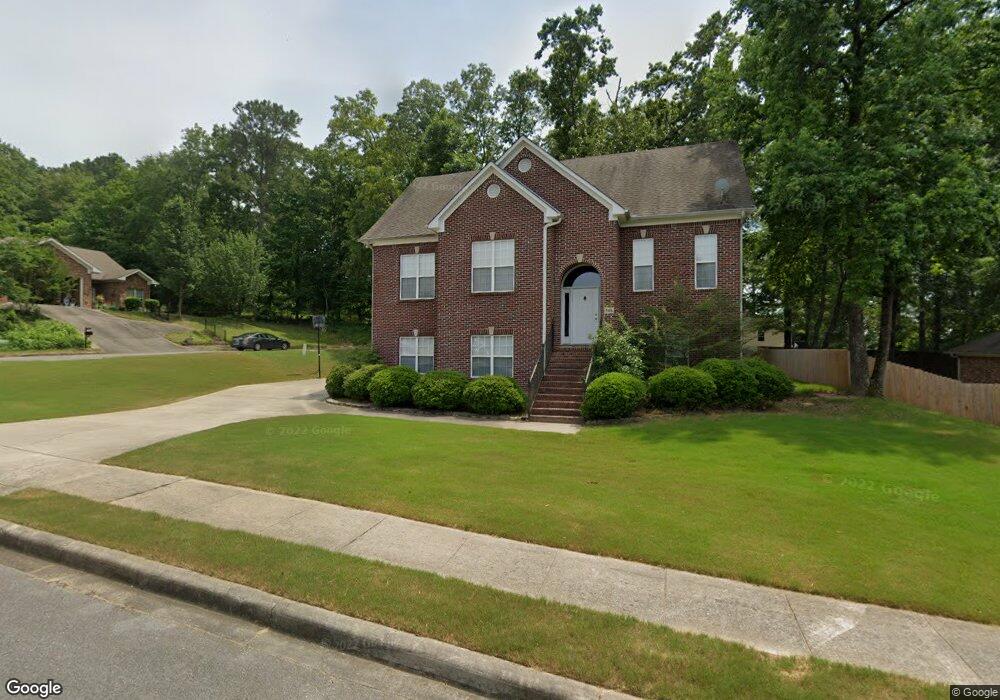
301 Meadow Cir Maylene, AL 35114
Estimated Value: $289,000 - $313,000
3
Beds
2
Baths
1,947
Sq Ft
$156/Sq Ft
Est. Value
About This Home
This home is located at 301 Meadow Cir, Maylene, AL 35114 and is currently estimated at $303,266, approximately $155 per square foot. 301 Meadow Cir is a home located in Shelby County with nearby schools including Thompson Intermediate School, Thompson Middle School, and Thompson High School.
Ownership History
Date
Name
Owned For
Owner Type
Purchase Details
Closed on
Aug 23, 2010
Sold by
Household Finance Corporation Of Alabama
Bought by
Long Kevin L and Long Erica P
Current Estimated Value
Home Financials for this Owner
Home Financials are based on the most recent Mortgage that was taken out on this home.
Original Mortgage
$119,200
Interest Rate
4.36%
Mortgage Type
New Conventional
Purchase Details
Closed on
Jan 27, 2006
Sold by
Buck Creek Construction Inc
Bought by
Mace James A and Mace Lisa D
Home Financials for this Owner
Home Financials are based on the most recent Mortgage that was taken out on this home.
Original Mortgage
$152,000
Interest Rate
7.39%
Mortgage Type
Fannie Mae Freddie Mac
Create a Home Valuation Report for This Property
The Home Valuation Report is an in-depth analysis detailing your home's value as well as a comparison with similar homes in the area
Home Values in the Area
Average Home Value in this Area
Purchase History
| Date | Buyer | Sale Price | Title Company |
|---|---|---|---|
| Long Kevin L | $149,000 | None Available | |
| Mace James A | $190,000 | None Available |
Source: Public Records
Mortgage History
| Date | Status | Borrower | Loan Amount |
|---|---|---|---|
| Previous Owner | Long Kevin L | $119,200 | |
| Previous Owner | Mace James A | $152,000 |
Source: Public Records
Tax History
| Year | Tax Paid | Tax Assessment Tax Assessment Total Assessment is a certain percentage of the fair market value that is determined by local assessors to be the total taxable value of land and additions on the property. | Land | Improvement |
|---|---|---|---|---|
| 2024 | $1,602 | $29,660 | $0 | $0 |
| 2023 | $1,462 | $27,840 | $0 | $0 |
| 2022 | $1,197 | $22,920 | $0 | $0 |
| 2021 | $1,075 | $20,660 | $0 | $0 |
| 2020 | $1,028 | $19,800 | $0 | $0 |
| 2019 | $997 | $19,220 | $0 | $0 |
| 2017 | $936 | $18,100 | $0 | $0 |
| 2015 | $900 | $17,420 | $0 | $0 |
| 2014 | $877 | $17,000 | $0 | $0 |
Source: Public Records
Map
Nearby Homes
- 445 Ramsgate Dr
- 120 Mayfair Park
- 2001 1st Ave W
- 306 Mayfair Cir
- 1805 Mohawk Dr
- 208 Queens Gate
- 1807 Apache Way
- 236 Queens Gate
- 501 Ramsgate Dr
- 312 Cornwall Dr
- 537 Ramsgate Dr
- 544 Ramsgate Dr
- 305 Cedar Grove Ct
- 309 Cedar Grove Ct
- 545 Ramsgate Dr
- 549 Ramsgate Dr
- 280 Cedar Grove Pkwy
- 542 Navajo Trail
- 1307 3rd Ave SW
- 316 Sterling Manor Cir
- 303 Meadow Cir
- 267 Cedar Meadow
- 305 Meadow Cir
- 305 Meadow Cir
- 397 Cedar Ln
- 263 Cedar Meadow
- 304 Meadow Cir
- 252 Cedar Meadow
- 259 Cedar Meadow
- 308 Meadow Cir
- 307 Meadow Cir
- 257 Cedar Meadow
- 506 Cedar Ln
- 248 Cedar Meadow
- 253 Cedar Meadow
- 236 Cedar Meadow
- 240 Cedar Meadow
- 232 Cedar Meadow
- 437 Ramsgate Dr
- 437 Ramsgate Dr Unit 382
Your Personal Tour Guide
Ask me questions while you tour the home.