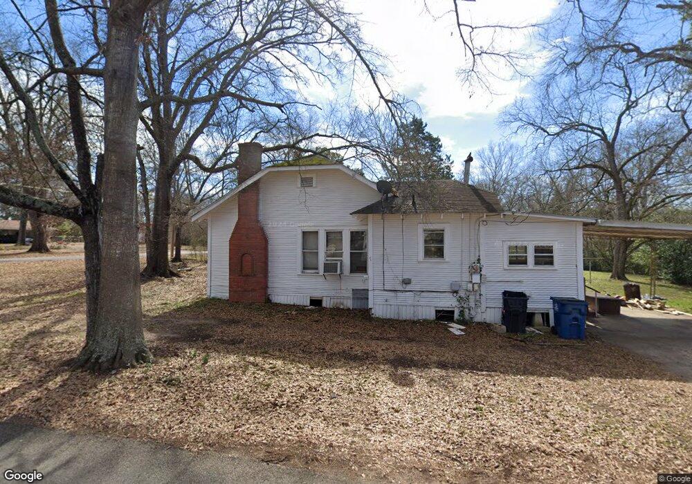
301 S 2nd St Vivian, LA 71082
Estimated Value: $54,000 - $65,000
1
Bed
1
Bath
1,031
Sq Ft
$55/Sq Ft
Est. Value
About This Home
This home is located at 301 S 2nd St, Vivian, LA 71082 and is currently estimated at $57,143, approximately $55 per square foot. 301 S 2nd St is a home located in Caddo Parish with nearby schools including South Highlands Elementary, Judson Fundamental Elementary School, and Fairfield Magnet School.
Ownership History
Date
Name
Owned For
Owner Type
Purchase Details
Closed on
Jan 24, 2025
Sold by
Alto Lawrence Kerry
Bought by
Nelson Charles Ray
Current Estimated Value
Purchase Details
Closed on
Apr 12, 2024
Sold by
Brown Daniel Richard
Bought by
Lawrence Kerry Alto
Purchase Details
Closed on
Apr 13, 2023
Sold by
Brown Daniel
Bought by
Starling Shannon Dominique
Purchase Details
Closed on
Apr 26, 2019
Sold by
Crow Findley Mary Frances
Bought by
Brown Peter R and Brown Marion Lisa
Create a Home Valuation Report for This Property
The Home Valuation Report is an in-depth analysis detailing your home's value as well as a comparison with similar homes in the area
Home Values in the Area
Average Home Value in this Area
Purchase History
| Date | Buyer | Sale Price | Title Company |
|---|---|---|---|
| Nelson Charles Ray | $50,000 | None Listed On Document | |
| Lawrence Kerry Alto | $27,910 | None Listed On Document | |
| Starling Shannon Dominique | $30,000 | None Listed On Document | |
| Brown Daniel | -- | None Listed On Document | |
| Brown Peter R | $13,000 | Chicago Title |
Source: Public Records
Tax History Compared to Growth
Tax History
| Year | Tax Paid | Tax Assessment Tax Assessment Total Assessment is a certain percentage of the fair market value that is determined by local assessors to be the total taxable value of land and additions on the property. | Land | Improvement |
|---|---|---|---|---|
| 2024 | $410 | $1,965 | $543 | $1,422 |
| 2023 | $413 | $1,940 | $518 | $1,422 |
| 2022 | $413 | $1,940 | $518 | $1,422 |
| 2021 | $413 | $1,940 | $518 | $1,422 |
| 2020 | $411 | $1,940 | $518 | $1,422 |
| 2019 | $407 | $1,939 | $518 | $1,421 |
| 2018 | $365 | $1,939 | $518 | $1,421 |
| 2017 | $406 | $1,939 | $518 | $1,421 |
| 2015 | $389 | $2,090 | $520 | $1,570 |
| 2014 | $391 | $2,090 | $520 | $1,570 |
| 2013 | -- | $2,090 | $520 | $1,570 |
Source: Public Records
Map
Nearby Homes
- 122 S Bird St
- 9794 Upper State Line Rd
- 310 W Tennessee Ave
- 425 N Cypress St
- 210 W Mississippi Ave
- 109 N Huckaby St
- 325 E Oklahoma Ave
- 9420 Hosston Rd
- Lot 14 Peaceful Pines Ln
- Lot 4 Peaceful Pines Ln
- Lot 2 Peaceful Pines Ln
- Lot 6 Peaceful Pines Ln
- Lot 5 Peaceful Pines Ln
- Lot 12 Peaceful Pines Ln
- 1220 N Carson St
- 62011 Rebel Heights Rd
- 9008 Hosston Vivian Rd
- 10651 Murry Ln
- 2040 Ma County Road 3509
- 2040 McR 3509
- 707 W Georgia Ave
- 707 W Georgia Ave
- 707 W Georgia Ave
- 707 W Georgia Ave
- 707 W Georgia Ave
- 707 W Georgia Ave
- 707 W Georgia Ave
- 707 W Georgia Ave
- 315 S 2nd St
- 229 S 2nd St
- 706 W Georgia Ave
- 618 W Georgia Ave
- 615 W Georgia Ave
- 709 W Georgia Ave
- 319 S 2nd St
- 710 W Georgia Ave
- 703 W Arkansas Ave
- 711 W Georgia Ave
- 218 S 2nd St
- 225 S Bird St