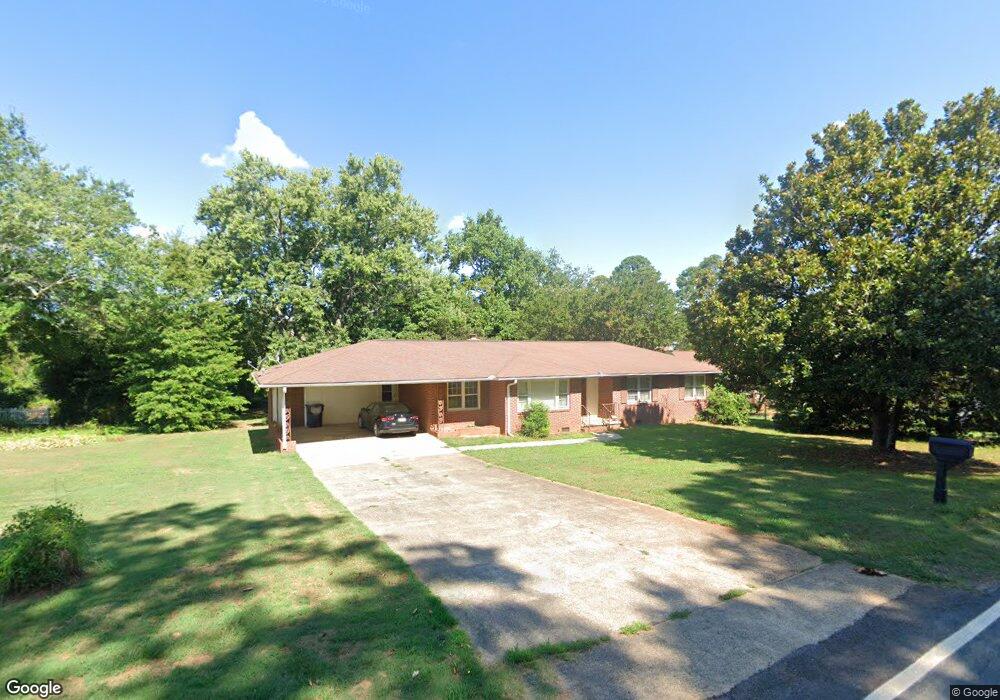
302 Phil Watson Rd Anderson, SC 29625
Estimated Value: $270,948 - $277,000
4
Beds
2
Baths
1,825
Sq Ft
$150/Sq Ft
Est. Value
About This Home
This home is located at 302 Phil Watson Rd, Anderson, SC 29625 and is currently estimated at $273,237, approximately $149 per square foot. 302 Phil Watson Rd is a home located in Anderson County with nearby schools including Whitehall Elementary School, Westside High School, and Anderson Institute of Technology.
Ownership History
Date
Name
Owned For
Owner Type
Purchase Details
Closed on
Oct 25, 2021
Sold by
Davis Mary W and Dunlap Mary W
Bought by
Clinemyer Preston
Current Estimated Value
Home Financials for this Owner
Home Financials are based on the most recent Mortgage that was taken out on this home.
Original Mortgage
$153,500
Outstanding Balance
$140,281
Interest Rate
2.8%
Mortgage Type
New Conventional
Estimated Equity
$132,956
Purchase Details
Closed on
Sep 30, 2009
Sold by
Burden Frankie
Bought by
Davis Mary W
Home Financials for this Owner
Home Financials are based on the most recent Mortgage that was taken out on this home.
Original Mortgage
$117,826
Interest Rate
5.11%
Mortgage Type
FHA
Purchase Details
Closed on
Jul 14, 2008
Sold by
Kovach Audrey and Olsson Wayne
Bought by
Burden Frankie
Home Financials for this Owner
Home Financials are based on the most recent Mortgage that was taken out on this home.
Original Mortgage
$90,000
Interest Rate
6.34%
Mortgage Type
Credit Line Revolving
Create a Home Valuation Report for This Property
The Home Valuation Report is an in-depth analysis detailing your home's value as well as a comparison with similar homes in the area
Home Values in the Area
Average Home Value in this Area
Purchase History
| Date | Buyer | Sale Price | Title Company |
|---|---|---|---|
| Clinemyer Preston | $190,000 | None Available | |
| Davis Mary W | $120,000 | -- | |
| Burden Frankie | $60,000 | -- |
Source: Public Records
Mortgage History
| Date | Status | Borrower | Loan Amount |
|---|---|---|---|
| Open | Clinemyer Preston | $153,500 | |
| Previous Owner | Davis Mary W | $117,826 | |
| Previous Owner | Burden Frankie | $90,000 |
Source: Public Records
Tax History
| Year | Tax Paid | Tax Assessment Tax Assessment Total Assessment is a certain percentage of the fair market value that is determined by local assessors to be the total taxable value of land and additions on the property. | Land | Improvement |
|---|---|---|---|---|
| 2024 | $965 | $7,750 | $1,240 | $6,510 |
| 2023 | $971 | $7,750 | $1,240 | $6,510 |
| 2022 | $3,707 | $11,630 | $1,860 | $9,770 |
| 2021 | $662 | $5,230 | $800 | $4,430 |
| 2020 | $662 | $5,230 | $800 | $4,430 |
| 2019 | $662 | $5,230 | $800 | $4,430 |
| 2018 | $673 | $5,230 | $800 | $4,430 |
| 2017 | -- | $5,230 | $800 | $4,430 |
| 2016 | $624 | $4,800 | $720 | $4,080 |
| 2015 | $637 | $4,800 | $720 | $4,080 |
| 2014 | $632 | $4,800 | $720 | $4,080 |
Source: Public Records
Map
Nearby Homes
- 505 Brookgreen Ct
- 300 Woodfern Cir
- 119 Sydney Ct
- 18 Sweetgrass Trail Unit 9
- 23 Sweetgrass Trail Unit 14
- 4214 Hembree Creek Rd
- 206 Timberlake Rd
- 304 Merriman Trail
- 104 Worsham Ln
- 212 Middleton Shores Dr
- 112 Northlake Dr
- 1502 Northlake Dr
- 101 Northlake Dr
- 902 Northlake Dr
- 501 Northlake Dr Unit Building 5
- 701 Northlake Dr
- 805 Northlake Dr Unit 8E
- 8 Cringle Ln
- 4115 Liberty Hwy
- 216 Maplewood Rd
- 302 Phil Watson Rd Unit Lot 119
- 304 Phil Watson Rd
- 401 Binewood Ln
- 403 Binewood Ln
- Lt 129,30,31,32 Phil Watson Rd
- Lot 132 Phil Watson Rd
- 216 Phil Watson Rd
- 711 Timberlake Rd
- 405 Binewood Ln
- 00 Binewood Ln
- 301 Phil Watson Rd
- 502 Woodfern Cir
- 705 Timberlake Rd
- 714 Timberlake Rd
- 401 Phil Watson Rd
- 402 Binewood Ln
- 407 Binewood Ln
- 225 Phil Watson Rd
- 224 Phil Watson Rd
- 712 Timberlake Rd
Your Personal Tour Guide
Ask me questions while you tour the home.