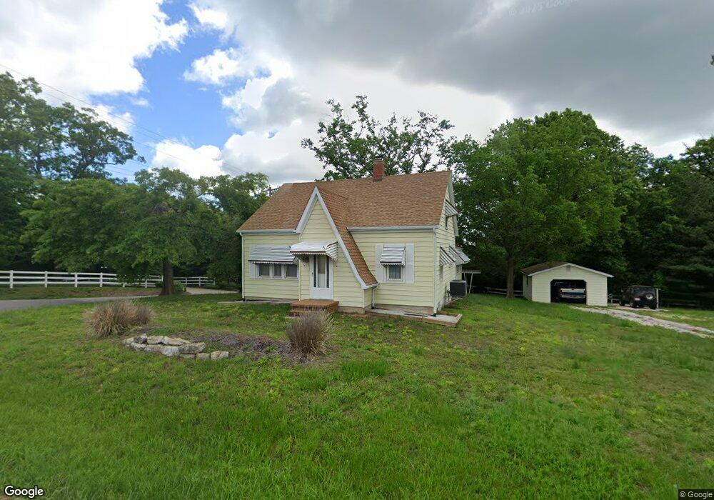
3020 Highway A Washington, MO 63090
Estimated Value: $164,000 - $250,141
3
Beds
1
Bath
1,384
Sq Ft
$154/Sq Ft
Est. Value
About This Home
This home is located at 3020 Highway A, Washington, MO 63090 and is currently estimated at $213,035, approximately $153 per square foot. 3020 Highway A is a home located in Franklin County with nearby schools including Washington High School, St. Gertrude Catholic School, and Immanuel Lutheran School.
Ownership History
Date
Name
Owned For
Owner Type
Purchase Details
Closed on
Nov 17, 2025
Sold by
Blanner Daryl
Bought by
Seals Property Llc
Current Estimated Value
Home Financials for this Owner
Home Financials are based on the most recent Mortgage that was taken out on this home.
Original Mortgage
$175,000
Outstanding Balance
$175,000
Interest Rate
6.3%
Mortgage Type
Credit Line Revolving
Estimated Equity
$38,035
Purchase Details
Closed on
Sep 16, 2022
Sold by
Kluba and Geneva
Bought by
Blanner Daryl
Purchase Details
Closed on
Jul 13, 2012
Sold by
Williams Carol Ann and The Mabel C Beste Revocable Li
Bought by
Kluba Joseph and Kluba Geneva
Create a Home Valuation Report for This Property
The Home Valuation Report is an in-depth analysis detailing your home's value as well as a comparison with similar homes in the area
Purchase History
| Date | Buyer | Sale Price | Title Company |
|---|---|---|---|
| Seals Property Llc | -- | None Listed On Document | |
| Blanner Daryl | -- | -- | |
| Kluba Joseph | -- | None Available |
Source: Public Records
Mortgage History
| Date | Status | Borrower | Loan Amount |
|---|---|---|---|
| Open | Seals Property Llc | $175,000 |
Source: Public Records
Tax History
| Year | Tax Paid | Tax Assessment Tax Assessment Total Assessment is a certain percentage of the fair market value that is determined by local assessors to be the total taxable value of land and additions on the property. | Land | Improvement |
|---|---|---|---|---|
| 2025 | $1,271 | $24,081 | $0 | $0 |
| 2024 | $1,271 | $23,051 | $0 | $0 |
| 2023 | $1,243 | $23,051 | $0 | $0 |
| 2022 | $1,088 | $20,220 | $0 | $0 |
| 2021 | $1,085 | $20,220 | $0 | $0 |
| 2020 | $1,014 | $18,187 | $0 | $0 |
| 2019 | $1,011 | $18,187 | $0 | $0 |
| 2018 | $988 | $17,630 | $0 | $0 |
| 2017 | $986 | $17,630 | $0 | $0 |
| 2016 | $952 | $17,313 | $0 | $0 |
| 2015 | $900 | $17,313 | $0 | $0 |
| 2014 | $957 | $18,424 | $0 | $0 |
Source: Public Records
Map
Nearby Homes
- 6414 Country Club Rd
- 2872 Highway A
- 22+/-acres Highway A and Broadmoor
- 311 Englewood Ct
- 18 Cobblestone Dr
- 0 N 4 Mile (Lot 5) Rd
- 797 Sydney Ct
- 773 Sydney Ct
- 881 Cobblestone (Lot 16) Dr
- 774 Sydney Ct
- 509 Mill Creek (Lot 45) Ln
- 541 Rock Creek Dr
- 677 Greystone (Lot 29) Dr
- 6560 Highway Bb
- 7040 Highway Yy
- 116 Walnut Hill Ct
- 5728 Country Club Rd
- 371 Peaceful Hollow Dr
- 1716 Pottery Rd
- 419 Cloverleaf Dr
- 3020 Highway A
- 3020 Highway A
- 3030 Highway A
- 3038 Highway A
- 3038 Highway A
- 6475 Country Club Rd
- 3039 Highway A
- 3045 Highway A
- 3052 Highway A Unit B
- 3050 Highway A
- 3053 Highway A
- 5265 Highway A
- 2979 Highway A
- 6505 Highway Yy
- 2976 Highway A
- 0Lot 5-A Hwy Yy
- 3070 Highway A
- 2975 Highway A
- 2975 Highway A
- 2961 Highway A
Your Personal Tour Guide
Ask me questions while you tour the home.