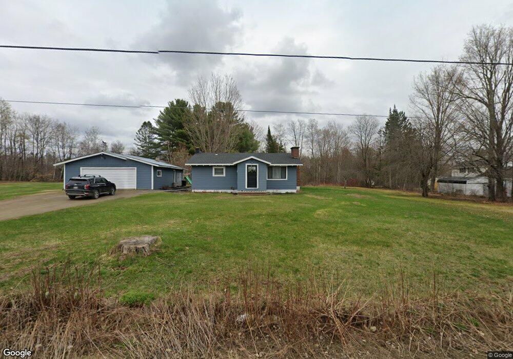
305 Kenduskeag Rd Levant, ME 04456
Estimated Value: $260,549 - $283,000
2
Beds
1
Bath
1,076
Sq Ft
$252/Sq Ft
Est. Value
About This Home
This home is located at 305 Kenduskeag Rd, Levant, ME 04456 and is currently estimated at $271,137, approximately $251 per square foot. 305 Kenduskeag Rd is a home located in Penobscot County with nearby schools including Suzanne M. Smith Elementary School and Caravel Middle School.
Ownership History
Date
Name
Owned For
Owner Type
Purchase Details
Closed on
Aug 22, 2006
Sold by
Young Rhoda M and Young Rhoda
Bought by
Curtis Jamie L and Birmingham William J
Current Estimated Value
Home Financials for this Owner
Home Financials are based on the most recent Mortgage that was taken out on this home.
Original Mortgage
$102,000
Outstanding Balance
$61,078
Interest Rate
7%
Mortgage Type
Adjustable Rate Mortgage/ARM
Estimated Equity
$210,059
Create a Home Valuation Report for This Property
The Home Valuation Report is an in-depth analysis detailing your home's value as well as a comparison with similar homes in the area
Home Values in the Area
Average Home Value in this Area
Purchase History
| Date | Buyer | Sale Price | Title Company |
|---|---|---|---|
| Curtis Jamie L | -- | -- |
Source: Public Records
Mortgage History
| Date | Status | Borrower | Loan Amount |
|---|---|---|---|
| Open | Curtis Jamie L | $102,000 | |
| Closed | Curtis Jamie L | $25,500 |
Source: Public Records
Tax History
| Year | Tax Paid | Tax Assessment Tax Assessment Total Assessment is a certain percentage of the fair market value that is determined by local assessors to be the total taxable value of land and additions on the property. | Land | Improvement |
|---|---|---|---|---|
| 2025 | $2,192 | $182,700 | $43,300 | $139,400 |
| 2024 | $2,010 | $182,700 | $43,300 | $139,400 |
| 2023 | $1,996 | $169,900 | $43,300 | $126,600 |
| 2022 | $2,007 | $114,700 | $33,700 | $81,000 |
| 2021 | $2,007 | $114,700 | $33,700 | $81,000 |
| 2020 | $2,209 | $114,700 | $33,700 | $81,000 |
| 2019 | $484 | $114,700 | $33,700 | $81,000 |
| 2018 | $695 | $115,100 | $33,700 | $81,400 |
| 2017 | $1,454 | $107,700 | $33,700 | $74,000 |
| 2016 | $1,346 | $107,700 | $33,700 | $74,000 |
| 2015 | $1,346 | $107,700 | $33,700 | $74,000 |
| 2014 | $1,346 | $107,700 | $33,700 | $74,000 |
Source: Public Records
Map
Nearby Homes
- 70 Clark Rd
- 9A Clark Rd
- Lot #7 Kenduskeag Levant Rd
- 536 Phillips Rd
- 8 Black Stream Dr
- 3935 Union St
- Lot 7-46-9 Clewley Rd
- 9 Thibodeau Dr
- 163 Phillips Rd
- 67 Stacey Ln
- 32 Center St
- 34 Center St
- 3036 Ohio St
- 9 Jipson Ln
- 503 Stetson Rd
- 4191 Union St
- 46 Overfar Way
- Lot 15-15 Stetson Rd E
- 40 Cookson
- 189 Stetson Rd E
- 299 Kenduskeag Rd
- 0 Kenduskeag Levant Rd Unit 1110958
- 0 Kenduskeag Levant Rd Unit 1101243
- 287 Kenduskeag Rd
- 282 Kenduskeag Rd
- 358 Kenduskeag Levant Rd
- 321 Kenduskeag Rd
- 352 Kenduskeag Levant Rd
- 396 Kenduskeag Levant Rd
- 362 Kenduskeag-Levant Rd
- 362 Kenduskeag Levant Rd
- 388 Kenduskeag-Levant Rd
- 380 Kenduskeag Levant Rd
- 318 Kenduskeag Rd
- 383 Kenduskeag Levant Rd
- M2L3 Levant Rd
- 228 Kenduskeag Rd
- 417 Kenduskeag Levant Rd
- 181 Kenduskeag Rd
- Lot #5 Kenduskeag-Levant Rd
Your Personal Tour Guide
Ask me questions while you tour the home.