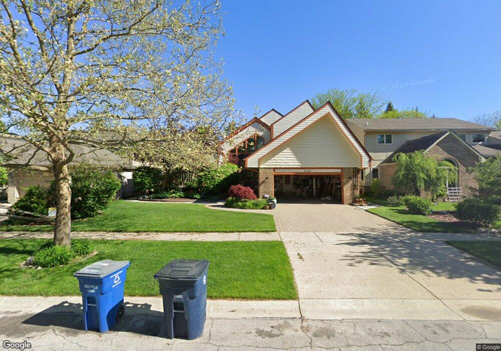
3095 Cedarbrook Rd Ann Arbor, MI 48105
Orchard Hills-Maplewood NeighborhoodEstimated Value: $644,000 - $742,000
4
Beds
4
Baths
2,853
Sq Ft
$244/Sq Ft
Est. Value
About This Home
This home is located at 3095 Cedarbrook Rd, Ann Arbor, MI 48105 and is currently estimated at $696,590, approximately $244 per square foot. 3095 Cedarbrook Rd is a home located in Washtenaw County with nearby schools including Thurston Elementary School, Clague Middle School, and Huron High School.
Ownership History
Date
Name
Owned For
Owner Type
Purchase Details
Closed on
Aug 31, 2012
Sold by
Mclaren Ian D
Bought by
Mclaren Ian D and Thornton Amanda Jayne
Current Estimated Value
Purchase Details
Closed on
Apr 3, 2001
Sold by
Mclaren Deborah S
Bought by
Mclaren Ian D
Purchase Details
Closed on
Apr 12, 1996
Sold by
Line Robert A
Bought by
Mclaren Ian D
Home Financials for this Owner
Home Financials are based on the most recent Mortgage that was taken out on this home.
Original Mortgage
$245,250
Interest Rate
7.5%
Mortgage Type
New Conventional
Create a Home Valuation Report for This Property
The Home Valuation Report is an in-depth analysis detailing your home's value as well as a comparison with similar homes in the area
Home Values in the Area
Average Home Value in this Area
Purchase History
| Date | Buyer | Sale Price | Title Company |
|---|---|---|---|
| Mclaren Ian D | -- | None Available | |
| Mclaren Ian D | $31,000 | -- | |
| Mclaren Ian D | $272,500 | -- |
Source: Public Records
Mortgage History
| Date | Status | Borrower | Loan Amount |
|---|---|---|---|
| Previous Owner | Mclaren Ian D | $245,250 |
Source: Public Records
Tax History
| Year | Tax Paid | Tax Assessment Tax Assessment Total Assessment is a certain percentage of the fair market value that is determined by local assessors to be the total taxable value of land and additions on the property. | Land | Improvement |
|---|---|---|---|---|
| 2025 | $11,910 | $387,100 | $0 | $0 |
| 2024 | $11,616 | $346,500 | $0 | $0 |
| 2023 | $10,710 | $309,000 | $0 | $0 |
| 2022 | $11,671 | $298,100 | $0 | $0 |
| 2021 | $11,342 | $348,700 | $0 | $0 |
| 2020 | $11,113 | $322,600 | $0 | $0 |
| 2019 | $10,576 | $305,400 | $305,400 | $0 |
| 2018 | $10,427 | $269,400 | $0 | $0 |
| 2017 | $10,143 | $272,700 | $0 | $0 |
| 2016 | $8,640 | $202,824 | $0 | $0 |
| 2015 | $9,319 | $202,218 | $0 | $0 |
| 2014 | $9,319 | $195,900 | $0 | $0 |
| 2013 | -- | $195,900 | $0 | $0 |
Source: Public Records
Map
Nearby Homes
- 2766 Maitland Dr
- 3057 Barclay Way Unit 265
- 3039 Barclay Way Unit 256
- 2856 Barclay Way Unit 38
- 1 Westbury Ct
- 3213 Kilburn Park Cir Unit 118
- 2877 Rayfield Ave
- 3209 Aldwych Cir
- 2824 Ridington Rd
- 2781 Barclay Way
- 3349 Burbank Dr
- 2822 Purley Ave
- 2605 Nadia Ct Unit 8
- 3250 Brackley Dr
- 3418 Burbank Dr Unit 367
- 4763 Curtis
- 2805 Rathmore Ln
- 4990 Saddleridge
- 3252 Bolgos Cir
- 3105 Millbury Ln
- 3087 Cedarbrook Rd
- 3103 Cedarbrook Rd
- 3111 Cedarbrook Rd
- 3079 Cedarbrook Rd
- 3088 Cedarbrook Rd
- 3096 Cedarbrook Rd
- 3119 Cedarbrook Rd
- 3071 Cedarbrook Rd
- 3080 Cedarbrook Rd
- 3104 Cedarbrook Rd
- 0 Cedarbrook Rd
- 3072 Cedarbrook Rd
- 3112 Cedarbrook Rd
- 3063 Cedarbrook Rd
- 3064 Cedarbrook Rd
- 3139 Rumsey Dr
- 3127 Rumsey Dr
- 3056 Cedarbrook Rd
- 3055 Cedarbrook Rd
- 3115 Rumsey Dr
Your Personal Tour Guide
Ask me questions while you tour the home.