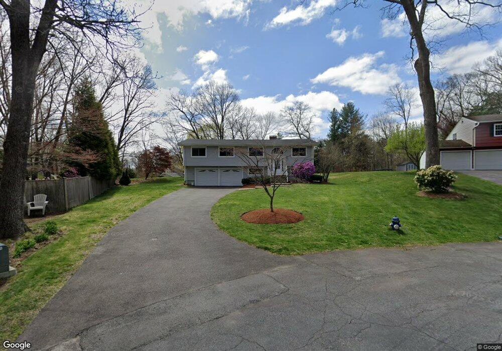
31 Lowe Cir Framingham, MA 01701
Nobscot NeighborhoodEstimated Value: $807,000 - $855,000
4
Beds
3
Baths
2,064
Sq Ft
$404/Sq Ft
Est. Value
About This Home
This home is located at 31 Lowe Cir, Framingham, MA 01701 and is currently estimated at $833,862, approximately $404 per square foot. 31 Lowe Cir is a home located in Middlesex County with nearby schools including Framingham High School and MetroWest Jewish Day School.
Ownership History
Date
Name
Owned For
Owner Type
Purchase Details
Closed on
Apr 12, 2017
Sold by
31 Lowe Circle T and Schiappa
Bought by
Marquis Peter and Marquis Megan
Current Estimated Value
Home Financials for this Owner
Home Financials are based on the most recent Mortgage that was taken out on this home.
Original Mortgage
$400,000
Outstanding Balance
$331,054
Interest Rate
4.1%
Mortgage Type
New Conventional
Estimated Equity
$502,808
Purchase Details
Closed on
Oct 24, 2012
Sold by
Schiappa Daniel
Bought by
31 Lowe Circle Rt and Schiappa
Purchase Details
Closed on
Sep 22, 2004
Sold by
Schiappa Daniel and Schiappa Kristina
Bought by
Schiappa Daniel C
Home Financials for this Owner
Home Financials are based on the most recent Mortgage that was taken out on this home.
Original Mortgage
$200,000
Interest Rate
5.89%
Mortgage Type
Purchase Money Mortgage
Purchase Details
Closed on
Feb 19, 1999
Sold by
London Richard M and London Mary A
Bought by
Schiappa Daniel and Schiappa Kristin
Purchase Details
Closed on
Apr 26, 1989
Sold by
Berk Richard H
Bought by
London Richard M
Create a Home Valuation Report for This Property
The Home Valuation Report is an in-depth analysis detailing your home's value as well as a comparison with similar homes in the area
Home Values in the Area
Average Home Value in this Area
Purchase History
| Date | Buyer | Sale Price | Title Company |
|---|---|---|---|
| Marquis Peter | $525,000 | -- | |
| Marquis Peter | $525,000 | -- | |
| 31 Lowe Circle Rt | -- | -- | |
| 31 Lowe Circle Rt | -- | -- | |
| Schiappa Daniel C | -- | -- | |
| Schiappa Daniel C | -- | -- | |
| Schiappa Daniel C | -- | -- | |
| Schiappa Daniel | $260,000 | -- | |
| London Richard M | $301,000 | -- | |
| London Richard M | $301,000 | -- |
Source: Public Records
Mortgage History
| Date | Status | Borrower | Loan Amount |
|---|---|---|---|
| Open | Marquis Peter | $400,000 | |
| Closed | Marquis Peter | $400,000 | |
| Previous Owner | London Richard M | $376,455 | |
| Previous Owner | Schiappa Daniel C | $200,000 |
Source: Public Records
Tax History Compared to Growth
Tax History
| Year | Tax Paid | Tax Assessment Tax Assessment Total Assessment is a certain percentage of the fair market value that is determined by local assessors to be the total taxable value of land and additions on the property. | Land | Improvement |
|---|---|---|---|---|
| 2025 | $9,728 | $814,700 | $271,500 | $543,200 |
| 2024 | $9,012 | $723,300 | $242,500 | $480,800 |
| 2023 | $8,489 | $648,500 | $216,400 | $432,100 |
| 2022 | $8,167 | $594,400 | $196,400 | $398,000 |
| 2021 | $8,238 | $586,300 | $188,800 | $397,500 |
| 2020 | $8,392 | $560,200 | $171,500 | $388,700 |
| 2019 | $8,325 | $541,300 | $171,500 | $369,800 |
| 2018 | $8,206 | $502,800 | $165,100 | $337,700 |
| 2017 | $7,565 | $452,700 | $160,300 | $292,400 |
| 2016 | $7,388 | $425,100 | $160,300 | $264,800 |
| 2015 | $7,657 | $429,700 | $160,800 | $268,900 |
Source: Public Records
Map
Nearby Homes
- 82 Joseph Rd
- 14 Francine Rd
- 30 Edith Rd
- 163 Water St
- 19 Park Ave
- 8 Clara Rd
- 53 Davidson Rd
- 24 Pinewood Dr
- 81 Nicholas Rd Unit B
- 1 Brookvale Rd
- 71 Nicholas Rd Unit H
- 217 Central St
- 15 Fairbrook Rd
- 27 Sloane Dr
- 40 Gregory Rd
- 8 Elm St Unit 8A
- 14 Eisenhower Rd
- 78 Apple d or Rd
- 10 Victoria Garden Unit A
- 18 Lomas Dr