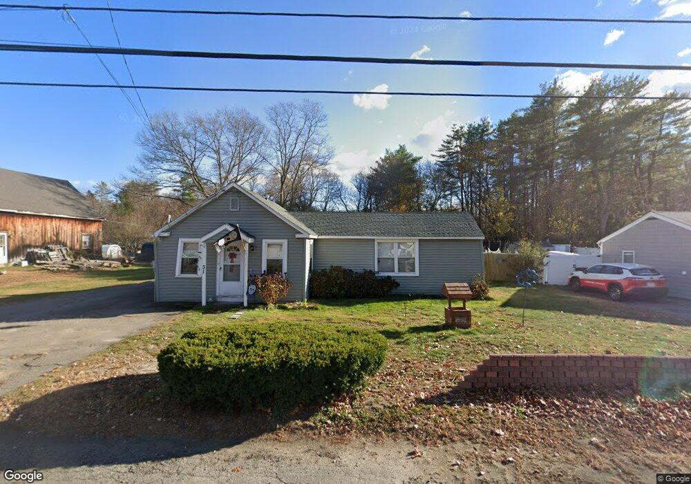
31 Main St Salisbury, MA 01952
Estimated Value: $461,000 - $507,707
3
Beds
1
Bath
930
Sq Ft
$518/Sq Ft
Est. Value
About This Home
This home is located at 31 Main St, Salisbury, MA 01952 and is currently estimated at $481,677, approximately $517 per square foot. 31 Main St is a home located in Essex County with nearby schools including Triton Regional High School.
Ownership History
Date
Name
Owned For
Owner Type
Purchase Details
Closed on
May 31, 2002
Sold by
Doherty Kristen and Nyhan-Hall Kristen
Bought by
Dellolio Bryan and Dellolio Elizabeth
Current Estimated Value
Purchase Details
Closed on
Jun 2, 2000
Sold by
Stanley Levi C and Stanley Cathleen A
Bought by
Nyhan-Hall Kristen
Purchase Details
Closed on
May 31, 1996
Sold by
Alaska National Ptnrs
Bought by
White Magic Inc
Purchase Details
Closed on
May 29, 1996
Sold by
Richardson Rt
Bought by
Alaska National Ptnrs
Purchase Details
Closed on
May 28, 1991
Sold by
Lowe Virginia F
Bought by
Reeves John M
Create a Home Valuation Report for This Property
The Home Valuation Report is an in-depth analysis detailing your home's value as well as a comparison with similar homes in the area
Home Values in the Area
Average Home Value in this Area
Purchase History
| Date | Buyer | Sale Price | Title Company |
|---|---|---|---|
| Dellolio Bryan | $189,900 | -- | |
| Nyhan-Hall Kristen | $117,000 | -- | |
| White Magic Inc | $300,000 | -- | |
| Alaska National Ptnrs | $300,000 | -- | |
| Reeves John M | $150,000 | -- |
Source: Public Records
Mortgage History
| Date | Status | Borrower | Loan Amount |
|---|---|---|---|
| Open | Reeves John M | $186,900 | |
| Closed | Reeves John M | $44,000 | |
| Closed | Reeves John M | $42,000 |
Source: Public Records
Tax History Compared to Growth
Tax History
| Year | Tax Paid | Tax Assessment Tax Assessment Total Assessment is a certain percentage of the fair market value that is determined by local assessors to be the total taxable value of land and additions on the property. | Land | Improvement |
|---|---|---|---|---|
| 2025 | $3,911 | $388,000 | $160,800 | $227,200 |
| 2024 | $3,938 | $376,800 | $160,800 | $216,000 |
| 2023 | $3,829 | $354,500 | $160,800 | $193,700 |
| 2022 | $3,770 | $338,400 | $144,700 | $193,700 |
| 2021 | $3,705 | $329,000 | $144,700 | $184,300 |
| 2020 | $3,400 | $296,700 | $144,700 | $152,000 |
| 2019 | $3,312 | $279,300 | $140,700 | $138,600 |
| 2018 | $3,150 | $267,400 | $129,100 | $138,300 |
| 2017 | $3,009 | $252,400 | $120,600 | $131,800 |
| 2016 | $2,934 | $251,400 | $116,600 | $134,800 |
| 2015 | $2,769 | $235,700 | $108,600 | $127,100 |
Source: Public Records
Map
Nearby Homes
- 241 & 245 Lafayette Rd
- 2 Collins St
- 10 High St
- 28 Brooks Rd
- 188 Lafayette Rd
- 7 Toll Rd
- 106 Folly Mill Rd
- 25 Bayberry Ln
- 154 Lafayette Rd
- 57 Washington St
- 20 Railroad Ave
- 42 Kendell Ln
- 81 Elm Ct
- 176 Lower Collins St
- 61 Folly Mill Rd
- 35 Norman Rd
- 22 Farm Ln
- 14 Coleman Ct
- 10 Caitlin Cir Unit B
- 8 Kimberly Dr