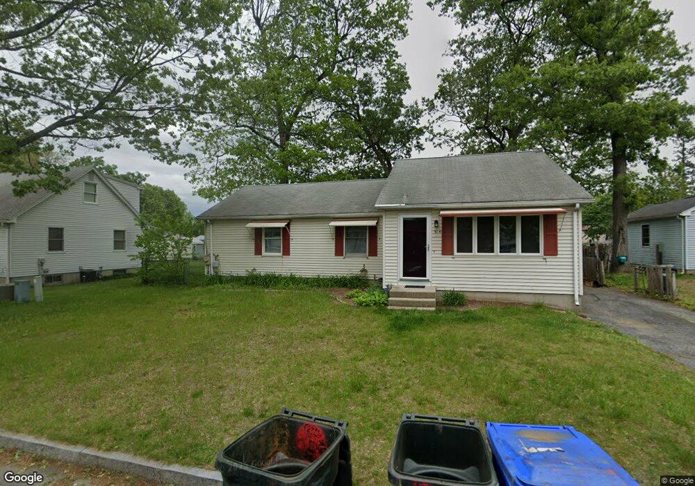
31 Pascal Dr Springfield, MA 01119
Pine Point NeighborhoodEstimated Value: $277,000 - $335,000
3
Beds
2
Baths
1,248
Sq Ft
$253/Sq Ft
Est. Value
About This Home
This home is located at 31 Pascal Dr, Springfield, MA 01119 and is currently estimated at $315,261, approximately $252 per square foot. 31 Pascal Dr is a home located in Hampden County with nearby schools including Thomas M Balliet Elementary School, John J Duggan Middle, and Springfield Central High School.
Ownership History
Date
Name
Owned For
Owner Type
Purchase Details
Closed on
Dec 31, 2008
Sold by
Bank Of New York
Bought by
Hernandez Stanley J and Hernandez Josette Love
Current Estimated Value
Home Financials for this Owner
Home Financials are based on the most recent Mortgage that was taken out on this home.
Original Mortgage
$109,000
Outstanding Balance
$72,139
Interest Rate
6.08%
Mortgage Type
VA
Estimated Equity
$243,122
Purchase Details
Closed on
Jun 16, 2008
Sold by
Watts Nancy
Bought by
Bank Of New York
Purchase Details
Closed on
Oct 20, 2005
Sold by
Cotto Marisol and Denson Eric
Bought by
Watts Richard and Watts Nancy
Home Financials for this Owner
Home Financials are based on the most recent Mortgage that was taken out on this home.
Original Mortgage
$118,650
Interest Rate
5.72%
Mortgage Type
Purchase Money Mortgage
Purchase Details
Closed on
May 3, 2004
Sold by
Cotto Marisol
Bought by
Denson Eric and Cotto Marisol
Home Financials for this Owner
Home Financials are based on the most recent Mortgage that was taken out on this home.
Original Mortgage
$108,000
Interest Rate
5.36%
Mortgage Type
Purchase Money Mortgage
Purchase Details
Closed on
Sep 5, 2002
Sold by
Lewis Janice J and Paul-Leslie Majorie
Bought by
Cotto Marisol
Home Financials for this Owner
Home Financials are based on the most recent Mortgage that was taken out on this home.
Original Mortgage
$106,067
Interest Rate
6.39%
Mortgage Type
Purchase Money Mortgage
Purchase Details
Closed on
Jun 30, 1997
Sold by
Blaxland David Q and Blaxland Jamie R
Bought by
Lewis Janice J and Leslie Marjorie P
Home Financials for this Owner
Home Financials are based on the most recent Mortgage that was taken out on this home.
Original Mortgage
$73,671
Interest Rate
7.81%
Mortgage Type
Purchase Money Mortgage
Purchase Details
Closed on
Jun 24, 1988
Sold by
Jc Becon Rlty Inc
Bought by
Blaxland David Q
Create a Home Valuation Report for This Property
The Home Valuation Report is an in-depth analysis detailing your home's value as well as a comparison with similar homes in the area
Home Values in the Area
Average Home Value in this Area
Purchase History
| Date | Buyer | Sale Price | Title Company |
|---|---|---|---|
| Hernandez Stanley J | $109,000 | -- | |
| Bank Of New York | $162,384 | -- | |
| Watts Richard | $158,200 | -- | |
| Denson Eric | -- | -- | |
| Cotto Marisol | $110,000 | -- | |
| Lewis Janice J | $74,000 | -- | |
| Blaxland David Q | $87,000 | -- |
Source: Public Records
Mortgage History
| Date | Status | Borrower | Loan Amount |
|---|---|---|---|
| Open | Hernandez Stanley J | $109,000 | |
| Previous Owner | Watts Richard | $118,650 | |
| Previous Owner | Watts Richard | $39,550 | |
| Previous Owner | Denson Eric | $108,000 | |
| Previous Owner | Blaxland David Q | $106,067 | |
| Previous Owner | Blaxland David Q | $2,950 | |
| Previous Owner | Blaxland David Q | $73,671 |
Source: Public Records
Tax History
| Year | Tax Paid | Tax Assessment Tax Assessment Total Assessment is a certain percentage of the fair market value that is determined by local assessors to be the total taxable value of land and additions on the property. | Land | Improvement |
|---|---|---|---|---|
| 2025 | $4,136 | $263,800 | $38,700 | $225,100 |
| 2024 | $3,832 | $238,600 | $38,700 | $199,900 |
| 2023 | $3,789 | $222,200 | $34,200 | $188,000 |
| 2022 | $3,433 | $182,400 | $32,000 | $150,400 |
| 2021 | $3,204 | $169,500 | $29,100 | $140,400 |
| 2020 | $3,224 | $165,100 | $29,100 | $136,000 |
| 2019 | $3,009 | $152,900 | $30,100 | $122,800 |
| 2018 | $2,867 | $145,700 | $30,100 | $115,600 |
| 2017 | $2,988 | $152,000 | $33,100 | $118,900 |
| 2016 | $2,595 | $132,000 | $33,100 | $98,900 |
| 2015 | $2,559 | $130,100 | $33,100 | $97,000 |
Source: Public Records
Map
Nearby Homes
- 195 Almira Rd
- 106 Almira Rd
- 130 Spear Rd
- 543 Boston Rd
- - Glenwood St
- 187 Lamont St
- 854 Grayson Dr
- 34 Wallace St
- 39 Wallace St
- 54 Bernard St
- 78 Massreco St
- 251 Rosewell St
- 64 Wilmington St
- 54 Seymour Ave
- 108 Barre St
- 56 Contessa Ln
- 70 Shumway St Unit 29
- 150 Seymour Ave
- 106-108 Breckwood Cir
- 19 Emily St
Your Personal Tour Guide
Ask me questions while you tour the home.