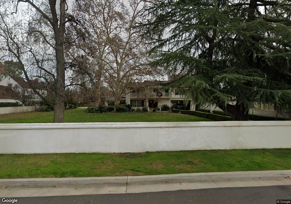
310 Mount Lowe Dr Bakersfield, CA 93309
Stockdale Estates NeighborhoodEstimated Value: $1,020,000 - $1,515,649
6
Beds
4
Baths
2,032
Sq Ft
$651/Sq Ft
Est. Value
About This Home
This home is located at 310 Mount Lowe Dr, Bakersfield, CA 93309 and is currently estimated at $1,322,550, approximately $650 per square foot. 310 Mount Lowe Dr is a home located in Kern County with nearby schools including Stockdale Elementary School, O.J. Actis Junior High School, and Bakersfield High School.
Ownership History
Date
Name
Owned For
Owner Type
Purchase Details
Closed on
Apr 11, 2023
Sold by
Tornstrom Robert E
Bought by
Tornstrom Family Trust
Current Estimated Value
Purchase Details
Closed on
Dec 16, 2014
Sold by
Tornstrom Robert E and Tornstrom Betty Jane
Bought by
Tornstrom Robert E
Purchase Details
Closed on
Apr 24, 1998
Sold by
Tornstrom Robert E
Bought by
Service Station Holdings Llc
Purchase Details
Closed on
Apr 21, 1995
Sold by
Gray James L and Gray Annette B
Bought by
Tornstrom Robert E and Tornstrom Betty Jane
Home Financials for this Owner
Home Financials are based on the most recent Mortgage that was taken out on this home.
Original Mortgage
$4,000,000
Interest Rate
8.47%
Create a Home Valuation Report for This Property
The Home Valuation Report is an in-depth analysis detailing your home's value as well as a comparison with similar homes in the area
Home Values in the Area
Average Home Value in this Area
Purchase History
| Date | Buyer | Sale Price | Title Company |
|---|---|---|---|
| Tornstrom Family Trust | -- | None Listed On Document | |
| Tornstrom Robert E | -- | None Available | |
| Service Station Holdings Llc | $116,000 | -- | |
| Tornstrom Robert E | $500,000 | Commonwealth Land Title Co |
Source: Public Records
Mortgage History
| Date | Status | Borrower | Loan Amount |
|---|---|---|---|
| Previous Owner | Tornstrom Robert E | $4,000,000 |
Source: Public Records
Tax History
| Year | Tax Paid | Tax Assessment Tax Assessment Total Assessment is a certain percentage of the fair market value that is determined by local assessors to be the total taxable value of land and additions on the property. | Land | Improvement |
|---|---|---|---|---|
| 2025 | $13,205 | $1,065,848 | $167,955 | $897,893 |
| 2024 | $13,205 | $1,044,950 | $164,662 | $880,288 |
| 2023 | $13,047 | $1,024,463 | $161,434 | $863,029 |
| 2022 | $12,531 | $1,004,377 | $158,269 | $846,108 |
| 2021 | $12,330 | $984,684 | $155,166 | $829,518 |
| 2020 | $12,196 | $974,588 | $153,575 | $821,013 |
| 2019 | $12,049 | $974,588 | $153,575 | $821,013 |
| 2018 | $11,436 | $936,746 | $147,612 | $789,134 |
| 2017 | $11,268 | $918,380 | $144,718 | $773,662 |
| 2016 | $10,437 | $900,374 | $141,881 | $758,493 |
| 2015 | $10,380 | $886,851 | $139,750 | $747,101 |
| 2014 | -- | $869,481 | $137,013 | $732,468 |
Source: Public Records
Map
Nearby Homes
- 6421 Mount Hood Dr
- 320 Hume Ln
- 416 River Oaks Dr
- 604 River Oaks Dr
- 841 Fairway Dr
- 6405 Desert Hills Ave
- 100 Stockdale Cir
- 601 Vista Verde Way
- 6216 Bel Aire Way
- 7012 Mesa Verde Way
- 504 Pebble Beach Dr
- 944 Fairway Dr
- 6108 Bel Aire Way
- 958 Fairway Dr
- 6201 Hartman Ave
- 1110 Fairway Dr
- 200 Carr St
- 205 Carr St
- 6309 Sundale Ave
- 112 Angell St
- 314 Mount Lowe Dr
- 306 Mount Lowe Dr
- 333 Fairway Dr
- 537 Fairway Dr
- 513 Fairway Dr
- 400 Mount Lowe Dr
- 6609 Mount Shasta Dr
- 304 Mount Lowe Dr
- 311 Fairway Dr
- 401 Fairway Dr
- 309 Fairway Dr
- 405 Fairway Dr
- 300 Mount Lowe Dr
- 400 Fairway Dr
- 404 Mount Lowe Dr
- 514 Fairway Dr
- 301 Fairway Dr
- 407 Fairway Dr
- 6509 Yosemite Place
- 410 Mount Lowe Dr
Your Personal Tour Guide
Ask me questions while you tour the home.