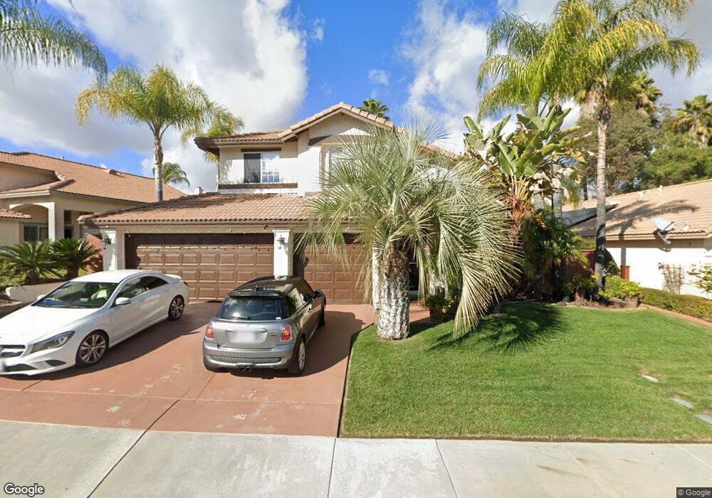
31076 Bunker Dr Temecula, CA 92591
Margarita Village-Temeku Hills NeighborhoodEstimated Value: $683,000 - $708,000
4
Beds
3
Baths
1,981
Sq Ft
$352/Sq Ft
Est. Value
About This Home
This home is located at 31076 Bunker Dr, Temecula, CA 92591 and is currently estimated at $698,041, approximately $352 per square foot. 31076 Bunker Dr is a home located in Riverside County with nearby schools including Vintage Hills Elementary School, Margarita Middle School, and Temecula Valley High School.
Ownership History
Date
Name
Owned For
Owner Type
Purchase Details
Closed on
Jul 24, 2015
Sold by
Shields Joseph M and Shields Maryann K
Bought by
Shields Family Trust
Current Estimated Value
Purchase Details
Closed on
Jun 16, 1997
Sold by
Udc Homes Inc
Bought by
Shields Joseph M and Shields Mary Ann K
Home Financials for this Owner
Home Financials are based on the most recent Mortgage that was taken out on this home.
Original Mortgage
$121,037
Outstanding Balance
$17,097
Interest Rate
7.83%
Estimated Equity
$680,944
Create a Home Valuation Report for This Property
The Home Valuation Report is an in-depth analysis detailing your home's value as well as a comparison with similar homes in the area
Home Values in the Area
Average Home Value in this Area
Purchase History
| Date | Buyer | Sale Price | Title Company |
|---|---|---|---|
| Shields Family Trust | -- | None Available | |
| Shields Joseph M | $156,000 | First American Title Ins Co |
Source: Public Records
Mortgage History
| Date | Status | Borrower | Loan Amount |
|---|---|---|---|
| Open | Shields Joseph M | $121,037 |
Source: Public Records
Tax History
| Year | Tax Paid | Tax Assessment Tax Assessment Total Assessment is a certain percentage of the fair market value that is determined by local assessors to be the total taxable value of land and additions on the property. | Land | Improvement |
|---|---|---|---|---|
| 2025 | $3,231 | $249,053 | $55,864 | $193,189 |
| 2023 | $3,231 | $239,384 | $53,696 | $185,688 |
| 2022 | $3,127 | $234,692 | $52,644 | $182,048 |
| 2021 | $3,058 | $230,091 | $51,612 | $178,479 |
| 2020 | $3,023 | $227,732 | $51,083 | $176,649 |
| 2019 | $2,979 | $223,268 | $50,082 | $173,186 |
| 2018 | $2,918 | $218,891 | $49,101 | $169,790 |
| 2017 | $2,865 | $214,600 | $48,139 | $166,461 |
| 2016 | $2,814 | $210,394 | $47,196 | $163,198 |
| 2015 | $2,763 | $207,236 | $46,488 | $160,748 |
| 2014 | $2,680 | $203,178 | $45,578 | $157,600 |
Source: Public Records
Map
Nearby Homes
- 41911 Driver Ln
- 30910 Crystalaire Dr
- 30874 Crystalaire Dr
- 41454 Avenida de la Reina
- 31060 Corte Anza
- 30816 Point Woods Ct
- 31376 Corte Montiel
- 31399 Paseo de Las Olas
- 31049 Corte Arroyo Vista
- 31130 S General Kearny Rd Unit 145
- 31130 S General Kearny Rd Unit 147
- 31130 S General Kearny Rd Unit 136
- 31130 S General Kearny Rd Unit 153
- 31130 S General Kearny Rd Unit 134
- 31130 S General Kearny Rd Unit 163
- 41552 Willow Run Rd
- 41451 Royal Dornoch Ct
- 41950 Delmonte St
- 30665 Feather Ct
- 31465 Inverness Ct
- 31068 Bunker Dr
- 31082 Bunker Dr
- 30967 Putter Cir
- 31062 Bunker Dr
- 31090 Bunker Dr
- 30959 Putter Cir
- 30975 Putter Cir
- 31054 Bunker Dr
- 30951 Putter Cir
- 31098 Bunker Dr
- 30983 Putter Cir
- 31067 Bunker Dr
- 31063 Bunker Dr
- 30943 Putter Cir
- 31073 Bunker Dr
- 31048 Bunker Dr
- 31055 Bunker Dr
- 31093 Bunker Dr
- 31106 Bunker Dr
- 30991 Putter Cir
Your Personal Tour Guide
Ask me questions while you tour the home.