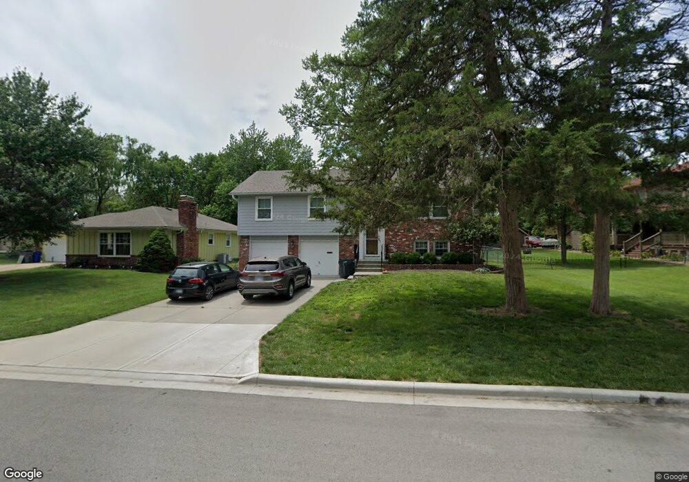
311 S Troost St Olathe, KS 66061
Estimated Value: $240,000 - $308,000
3
Beds
3
Baths
1,128
Sq Ft
$244/Sq Ft
Est. Value
About This Home
This home is located at 311 S Troost St, Olathe, KS 66061 and is currently estimated at $275,438, approximately $244 per square foot. 311 S Troost St is a home located in Johnson County with nearby schools including Westview Elementary School, Oregon Trail Middle School, and Olathe West High School.
Ownership History
Date
Name
Owned For
Owner Type
Purchase Details
Closed on
Apr 11, 2025
Sold by
James Jennifer L
Bought by
Manies Jennifer James and Manies Gregory Scott
Current Estimated Value
Purchase Details
Closed on
Jul 1, 2008
Sold by
Henning Bruce A and Henning Vicki L
Bought by
James Jennifer L
Home Financials for this Owner
Home Financials are based on the most recent Mortgage that was taken out on this home.
Original Mortgage
$155,769
Interest Rate
5.99%
Mortgage Type
FHA
Create a Home Valuation Report for This Property
The Home Valuation Report is an in-depth analysis detailing your home's value as well as a comparison with similar homes in the area
Home Values in the Area
Average Home Value in this Area
Purchase History
| Date | Buyer | Sale Price | Title Company |
|---|---|---|---|
| Manies Jennifer James | -- | None Listed On Document | |
| Manies Jennifer James | -- | None Listed On Document | |
| James Jennifer L | -- | Continental Title Co |
Source: Public Records
Mortgage History
| Date | Status | Borrower | Loan Amount |
|---|---|---|---|
| Previous Owner | James Jennifer L | $155,769 |
Source: Public Records
Tax History Compared to Growth
Tax History
| Year | Tax Paid | Tax Assessment Tax Assessment Total Assessment is a certain percentage of the fair market value that is determined by local assessors to be the total taxable value of land and additions on the property. | Land | Improvement |
|---|---|---|---|---|
| 2024 | $2,795 | $25,484 | $4,263 | $21,221 |
| 2023 | $2,740 | $24,242 | $4,263 | $19,979 |
| 2022 | $2,525 | $21,747 | $3,877 | $17,870 |
| 2021 | $2,525 | $20,010 | $3,522 | $16,488 |
| 2020 | $2,496 | $20,148 | $3,203 | $16,945 |
| 2019 | $2,538 | $20,344 | $2,783 | $17,561 |
| 2018 | $2,408 | $19,182 | $2,529 | $16,653 |
| 2017 | $2,287 | $18,044 | $2,529 | $15,515 |
| 2016 | $2,162 | $17,503 | $2,529 | $14,974 |
| 2015 | $2,123 | $17,204 | $2,529 | $14,675 |
| 2013 | -- | $16,192 | $2,298 | $13,894 |
Source: Public Records
Map
Nearby Homes
- 573 W Loula St
- 600 W Elm St
- 507 W Park St
- 617 S Grant St
- 812 S Troost St
- 1106 W Sheridan St
- 1200 W Sheridan St
- 109 E Cedar St
- 531 S Oscar St
- 1425 W Poplar St
- 1545 W Park St
- 1604 W Cedar St
- 335 S Water St
- 706 S Kansas Ave
- 612 N Logan St
- 401 S Harrison St
- 721 S Chestnut St
- 336 E Park St
- 233 S Chambery Dr
- 619 N Walnut St