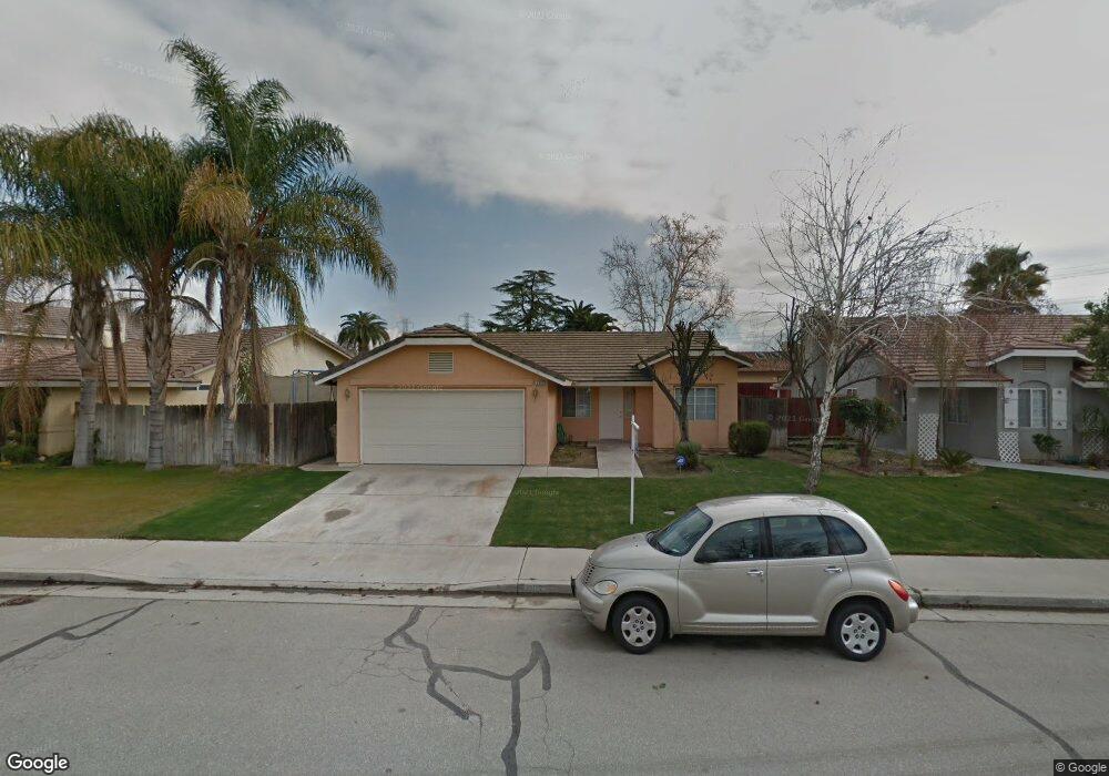
3112 Silver Spur Way Bakersfield, CA 93312
Estimated Value: $344,359 - $358,000
3
Beds
2
Baths
1,287
Sq Ft
$273/Sq Ft
Est. Value
About This Home
This home is located at 3112 Silver Spur Way, Bakersfield, CA 93312 and is currently estimated at $350,840, approximately $272 per square foot. 3112 Silver Spur Way is a home located in Kern County with nearby schools including Rosedale-North Elementary School, Freedom Middle School, and Centennial High School.
Ownership History
Date
Name
Owned For
Owner Type
Purchase Details
Closed on
Feb 12, 2004
Sold by
Combs David E and Combs Barbera
Bought by
Atristain Eric E
Current Estimated Value
Home Financials for this Owner
Home Financials are based on the most recent Mortgage that was taken out on this home.
Original Mortgage
$104,500
Outstanding Balance
$48,260
Interest Rate
5.61%
Mortgage Type
Purchase Money Mortgage
Estimated Equity
$302,580
Create a Home Valuation Report for This Property
The Home Valuation Report is an in-depth analysis detailing your home's value as well as a comparison with similar homes in the area
Home Values in the Area
Average Home Value in this Area
Purchase History
| Date | Buyer | Sale Price | Title Company |
|---|---|---|---|
| Atristain Eric E | $149,500 | First American Title |
Source: Public Records
Mortgage History
| Date | Status | Borrower | Loan Amount |
|---|---|---|---|
| Open | Atristain Eric E | $104,500 |
Source: Public Records
Tax History Compared to Growth
Tax History
| Year | Tax Paid | Tax Assessment Tax Assessment Total Assessment is a certain percentage of the fair market value that is determined by local assessors to be the total taxable value of land and additions on the property. | Land | Improvement |
|---|---|---|---|---|
| 2025 | $3,286 | $212,533 | $53,304 | $159,229 |
| 2024 | $3,215 | $208,366 | $52,259 | $156,107 |
| 2023 | $3,215 | $204,282 | $51,235 | $153,047 |
| 2022 | $3,131 | $200,278 | $50,231 | $150,047 |
| 2021 | $3,026 | $196,352 | $49,247 | $147,105 |
| 2020 | $2,966 | $194,340 | $48,743 | $145,597 |
| 2019 | $2,927 | $194,340 | $48,743 | $145,597 |
| 2018 | $2,841 | $186,796 | $46,851 | $139,945 |
| 2017 | $2,815 | $183,134 | $45,933 | $137,201 |
| 2016 | $2,567 | $179,544 | $45,033 | $134,511 |
| 2015 | $2,541 | $176,848 | $44,357 | $132,491 |
| 2014 | $2,375 | $163,000 | $41,000 | $122,000 |
Source: Public Records
Map
Nearby Homes
- 3122 Campfire Dr Unit 2
- 11617 Cactus Dr
- 11705 Cactus Dr
- 11201 Paddock Ave
- 3108 Holbrook St
- 11908 Nebula Ct
- 11910 Compass Ave
- 3622 Azure Dr
- 3613 Aslin St
- 11711 Stratosphere Ave
- 3435 Moss St
- 11265 Poulsen Way
- 10701 Meacham Rd
- 12421 Winn Ave
- 2710 Maher Way
- 4136 Jewetta Ave
- 10601 Michele Ave
- 10600 Michele Ave
- 11805 Hannah Denise Ave
- 10729 Lindalee Ln
- 3118 Silver Spur Way
- 11512 Lariat Ct
- 3104 Silver Spur Way
- 3124 Silver Spur Way
- 3113 Silver Spur Way
- 3109 Silver Spur Way
- 3117 Silver Spur Way
- 3100 Silver Spur Way
- 3105 Silver Spur Way
- 3121 Silver Spur Way
- 11513 Lariat Ct
- 3125 Silver Spur Way
- 3101 Silver Spur Way
- 3114 Campfire Dr
- 3110 Campfire Dr
- 3118 Campfire Dr
- 3117 Ranchgate Dr
- 3106 Campfire Dr Unit 2
- 11408 Lariat Ct
- 3108 Ranchgate Dr