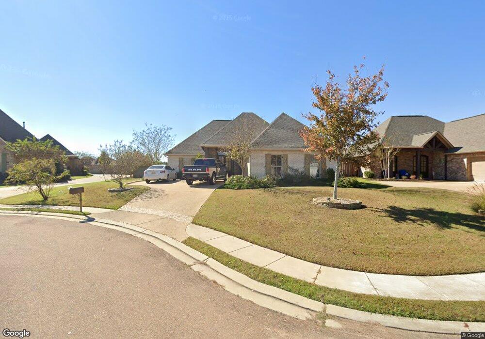
315 Emerald Way Brandon, MS 39047
Estimated Value: $342,165 - $363,000
3
Beds
2
Baths
2,469
Sq Ft
$142/Sq Ft
Est. Value
About This Home
This home is located at 315 Emerald Way, Brandon, MS 39047 and is currently estimated at $350,291, approximately $141 per square foot. 315 Emerald Way is a home located in Rankin County with nearby schools including Highland Bluff Elementary School, Northwest Rankin Middle School, and Northwest Rankin High School.
Ownership History
Date
Name
Owned For
Owner Type
Purchase Details
Closed on
Jan 12, 2023
Sold by
Harris Robert Casey
Bought by
Waggoner Ronald and Rlw1 Llc
Current Estimated Value
Purchase Details
Closed on
Jan 15, 2021
Sold by
Mitchell Thomas Steven
Bought by
Harris Robert Casey
Home Financials for this Owner
Home Financials are based on the most recent Mortgage that was taken out on this home.
Original Mortgage
$298,989
Interest Rate
2.71%
Mortgage Type
New Conventional
Purchase Details
Closed on
May 19, 2017
Sold by
Evans Peggy P
Bought by
Booth Robert S and Booth Susan
Purchase Details
Closed on
Dec 15, 2014
Sold by
Griffin Vicki M
Bought by
Booth Robert S and Booth Susan L
Home Financials for this Owner
Home Financials are based on the most recent Mortgage that was taken out on this home.
Original Mortgage
$216,000
Interest Rate
4.07%
Mortgage Type
New Conventional
Create a Home Valuation Report for This Property
The Home Valuation Report is an in-depth analysis detailing your home's value as well as a comparison with similar homes in the area
Purchase History
| Date | Buyer | Sale Price | Title Company |
|---|---|---|---|
| Waggoner Ronald | -- | Luckett Land Title | |
| Harris Robert Casey | -- | None Listed On Document | |
| Booth Robert S | -- | None Available | |
| Booth Robert S | -- | None Available |
Source: Public Records
Mortgage History
| Date | Status | Borrower | Loan Amount |
|---|---|---|---|
| Previous Owner | Harris Robert Casey | $298,989 | |
| Previous Owner | Booth Robert S | $216,000 |
Source: Public Records
Tax History
| Year | Tax Paid | Tax Assessment Tax Assessment Total Assessment is a certain percentage of the fair market value that is determined by local assessors to be the total taxable value of land and additions on the property. | Land | Improvement |
|---|---|---|---|---|
| 2025 | $3,071 | $25,466 | $0 | $0 |
| 2024 | $2,922 | $25,466 | $0 | $0 |
| 2023 | $2,930 | $22,566 | $0 | $0 |
| 2022 | $2,896 | $22,566 | $0 | $0 |
| 2021 | $4,657 | $33,849 | $0 | $0 |
| 2020 | $2,971 | $22,566 | $0 | $0 |
| 2019 | $2,716 | $20,080 | $0 | $0 |
| 2018 | $2,691 | $20,080 | $0 | $0 |
| 2017 | $2,713 | $20,080 | $0 | $0 |
| 2016 | $2,558 | $19,626 | $0 | $0 |
| 2015 | $2,558 | $19,626 | $0 | $0 |
| 2014 | $1,015 | $5,250 | $0 | $0 |
Source: Public Records
Map
Nearby Homes
- 125 Emerald Dr
- 601 Emerald Ct
- 301 Siltstone Ridge
- 613 Emerald Ct
- 600 Bauxite Cove
- 131 Cumberland Rd
- 154 Cumberland Rd
- 117 Cumberland Rd
- 735 Cotton Creek Trail
- 14 Brandy Ct S
- 1 Brandy Village Cove
- 231 Bronson Bend
- 201 Greenfield Place
- 300 Deer Hollow
- 0 Grants Ferry Rd Unit Part 1
- 215 Bronson Bend
- 539 Turtle Ln
- 109 Brandy Run Rd
- 230 Bronson Bend
- 232 Bronson Bend
- 315 Emerald Way
- 317 Emerald Way
- 317 Emerald Way
- 313 Emerald Way
- 319 Emerald Way
- 316 Emerald Way
- 316 Emerald Way
- 318 Emerald Way
- 309 Emerald Way
- 309 Emerald Way
- 318 Emerald Way
- 125 Amethyst Dr
- 125 Amethyst Dr
- 320 Emerald Way
- 320 Emerald Way
- 118 Amethyst Dr
- 127 Amethyst Dr
- 327 Emerald Way
- 403 Emerald Trail Dr
- 403 Emerald Trail
Your Personal Tour Guide
Ask me questions while you tour the home.