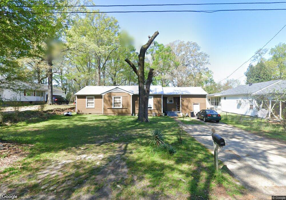
315 Oak St McComb, MS 39648
Estimated Value: $77,714 - $130,000
Studio
--
Bath
1,489
Sq Ft
$68/Sq Ft
Est. Value
About This Home
This home is located at 315 Oak St, McComb, MS 39648 and is currently estimated at $101,179, approximately $67 per square foot. 315 Oak St is a home with nearby schools including Otken Elementary School, Higgins Middle School, and Denman Junior High School.
Ownership History
Date
Name
Owned For
Owner Type
Purchase Details
Closed on
May 6, 2020
Sold by
Hl & C Pike Llc
Bought by
Greater Everyday Church
Current Estimated Value
Home Financials for this Owner
Home Financials are based on the most recent Mortgage that was taken out on this home.
Original Mortgage
$14,000
Interest Rate
2.8%
Mortgage Type
New Conventional
Purchase Details
Closed on
Dec 6, 2019
Sold by
On Point Llc
Bought by
Hl C Companies Llc
Purchase Details
Closed on
Mar 31, 2011
Sold by
Kalil Patricia N
Bought by
Kalil Raymond A and Kalil Rachel D
Create a Home Valuation Report for This Property
The Home Valuation Report is an in-depth analysis detailing your home's value as well as a comparison with similar homes in the area
Purchase History
| Date | Buyer | Sale Price | Title Company |
|---|---|---|---|
| Greater Everyday Church | -- | None Available | |
| Hl C Companies Llc | -- | None Available | |
| Kalil Raymond A | -- | None Available |
Source: Public Records
Mortgage History
| Date | Status | Borrower | Loan Amount |
|---|---|---|---|
| Previous Owner | Greater Everyday Church | $14,000 |
Source: Public Records
Tax History
| Year | Tax Paid | Tax Assessment Tax Assessment Total Assessment is a certain percentage of the fair market value that is determined by local assessors to be the total taxable value of land and additions on the property. | Land | Improvement |
|---|---|---|---|---|
| 2025 | $1,146 | $6,442 | $0 | $0 |
| 2024 | $1,026 | $5,744 | $0 | $0 |
| 2023 | $1,009 | $5,713 | $0 | $0 |
| 2022 | $994 | $5,713 | $0 | $0 |
| 2021 | $992 | $5,713 | $0 | $0 |
| 2020 | $958 | $5,518 | $0 | $0 |
| 2019 | $1,229 | $7,402 | $0 | $0 |
| 2018 | $598 | $4,935 | $0 | $0 |
| 2017 | $602 | $4,935 | $0 | $0 |
| 2016 | $596 | $4,935 | $0 | $0 |
| 2015 | -- | $4,834 | $0 | $0 |
| 2014 | -- | $4,834 | $0 | $0 |
| 2013 | -- | $4,834 | $0 | $0 |
Source: Public Records
Map
Nearby Homes
- 406 Aston Ave
- 402 Laurel St
- 427 Lakeview Ave
- 220 N James Ave
- 000 Rawls & White St
- 1018 Park St
- 400 Burke Ave
- 510 Lakeview Ave
- 310 Burke Ave
- 515 Lakeview Ave
- 509 Jackson Ave
- 800 Jackson Ave
- 612 W New York Ave
- 134 A & B W New York Ave
- 912 Laird St
- 215 Peach Ave
- TDB Delaware Ave
- 0 Llewellyn Ave
- 917 North St
- 309 West Ave S
Your Personal Tour Guide
Ask me questions while you tour the home.