Estimated Value: $341,000 - $459,000
3
Beds
2
Baths
1,860
Sq Ft
$210/Sq Ft
Est. Value
About This Home
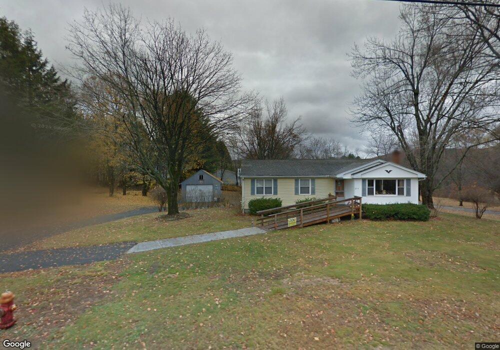
This home is located at 316 Palmer Rd, Ware, MA 01082 and is currently estimated at $389,812, approximately $209 per square foot. 316 Palmer Rd is a home located in Hampshire County with nearby schools including Stanley M. Koziol Elementary School, Ware Middle School, and Ware Junior/Senior High School.
Ownership History
Date
Name
Owned For
Owner Type
Purchase Details
Closed on
Mar 27, 1998
Sold by
Bator Bruce C and Bator Douglas J
Bought by
Bator Doreen M and Bator Douglas J
Current Estimated Value
Home Financials for this Owner
Home Financials are based on the most recent Mortgage that was taken out on this home.
Original Mortgage
$55,000
Outstanding Balance
$10,313
Interest Rate
6.96%
Mortgage Type
Purchase Money Mortgage
Estimated Equity
$379,499
Create a Home Valuation Report for This Property
The Home Valuation Report is an in-depth analysis detailing your home's value as well as a comparison with similar homes in the area
Home Values in the Area
Average Home Value in this Area
Purchase History
| Date | Buyer | Sale Price | Title Company |
|---|---|---|---|
| Bator Doreen M | $118,000 | -- |
Source: Public Records
Mortgage History
| Date | Status | Borrower | Loan Amount |
|---|---|---|---|
| Open | Bator Doreen M | $55,000 |
Source: Public Records
Tax History
| Year | Tax Paid | Tax Assessment Tax Assessment Total Assessment is a certain percentage of the fair market value that is determined by local assessors to be the total taxable value of land and additions on the property. | Land | Improvement |
|---|---|---|---|---|
| 2025 | $4,922 | $326,800 | $55,600 | $271,200 |
| 2024 | $4,710 | $288,400 | $52,400 | $236,000 |
| 2023 | $4,619 | $267,600 | $50,800 | $216,800 |
| 2022 | $4,510 | $233,200 | $47,000 | $186,200 |
| 2021 | $4,446 | $220,300 | $47,000 | $173,300 |
| 2020 | $4,283 | $207,600 | $47,000 | $160,600 |
| 2019 | $4,196 | $207,600 | $47,000 | $160,600 |
| 2018 | $4,014 | $193,800 | $45,800 | $148,000 |
| 2017 | $3,861 | $185,900 | $45,800 | $140,100 |
| 2016 | $3,757 | $185,900 | $45,800 | $140,100 |
| 2015 | $3,653 | $185,900 | $45,800 | $140,100 |
| 2014 | $3,691 | $201,600 | $47,900 | $153,700 |
Source: Public Records
Map
Nearby Homes
- 310 Palmer Rd
- 201 West St
- LOT 3 Monson Turnpike Rd
- 67 Babcock Tavern Rd
- 201 Belchertown Rd
- Lot 16 Coldbrook Dr
- Lot 20 Coldbrook Dr
- Lot 22 Coldbrook Dr
- Lot 13 Coldbrook Dr
- Lot 25 Coldbrook Dr
- 375 Belchertown Rd
- 378 Rondeau St
- 24 Clinton St
- 87 W Main St
- 30 Warebrook Village
- Lot 5 Babcock Tavern Rd
- Lot 4 Babcock Tavern Rd
- 57 Babcock Tavern Rd
- 49 Babcock Tavern Rd
- 23 West St Unit 25
- 5 Longview Ave
- 7 Longview Ave
- 312 Palmer Rd
- 312 Palmer Rd Unit 27000
- 6 Longview Ave
- 4 Longview Ave
- 318 Palmer Rd
- 11 Longview Ave
- 8 Longview Ave
- 2 Longview Ave
- 10 Longview Ave
- 7 Woodland Heights
- 5 Woodland Heights
- 320 Palmer Rd
- 9 Woodland Heights
- 12 Longview Ave
- 3 Woodland Heights
- 13 Longview Ave
- 315 Palmer Rd
- 14 Longview Ave
Your Personal Tour Guide
Ask me questions while you tour the home.