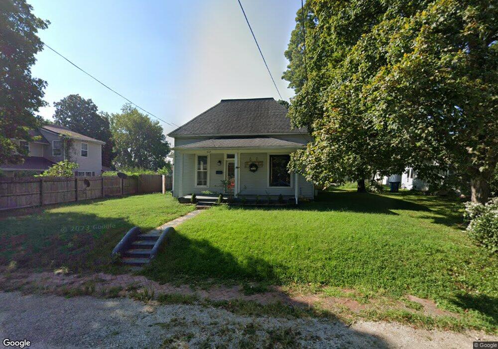
317 Adams St Neosho, MO 64850
Estimated Value: $123,000 - $126,000
3
Beds
1
Bath
1,128
Sq Ft
$110/Sq Ft
Est. Value
About This Home
This home is located at 317 Adams St, Neosho, MO 64850 and is currently estimated at $124,264, approximately $110 per square foot. 317 Adams St is a home located in Newton County with nearby schools including Neosho High School, Ozark Christian Academy, and Neosho Christian Schools.
Ownership History
Date
Name
Owned For
Owner Type
Purchase Details
Closed on
May 14, 2025
Sold by
Liv Tony A and Liv Tracy
Bought by
Newburn Breezy
Current Estimated Value
Home Financials for this Owner
Home Financials are based on the most recent Mortgage that was taken out on this home.
Original Mortgage
$120,341
Outstanding Balance
$120,341
Interest Rate
6.64%
Mortgage Type
New Conventional
Estimated Equity
$3,923
Purchase Details
Closed on
Jan 5, 2024
Sold by
Ttp Properties Llc
Bought by
Tony A And Tracy L Pickett Revocable Living T and Pickett
Purchase Details
Closed on
Jun 2, 2021
Sold by
Davesu Neosho Llc
Bought by
Ttp Properties Llc
Home Financials for this Owner
Home Financials are based on the most recent Mortgage that was taken out on this home.
Original Mortgage
$68,800
Interest Rate
2.9%
Mortgage Type
New Conventional
Purchase Details
Closed on
Nov 24, 2020
Sold by
Walker Rental Investments Llc
Bought by
Davesu Neosho Llc
Create a Home Valuation Report for This Property
The Home Valuation Report is an in-depth analysis detailing your home's value as well as a comparison with similar homes in the area
Home Values in the Area
Average Home Value in this Area
Purchase History
| Date | Buyer | Sale Price | Title Company |
|---|---|---|---|
| Newburn Breezy | -- | None Listed On Document | |
| Tony A And Tracy L Pickett Revocable Living T | -- | None Listed On Document | |
| Tony A And Tracy L Pickett Revocable Living T | -- | None Listed On Document | |
| Ttp Properties Llc | $91,504 | None Listed On Document | |
| Davesu Neosho Llc | -- | None Listed On Document |
Source: Public Records
Mortgage History
| Date | Status | Borrower | Loan Amount |
|---|---|---|---|
| Open | Newburn Breezy | $120,341 | |
| Previous Owner | Ttp Properties Llc | $68,800 |
Source: Public Records
Tax History Compared to Growth
Tax History
| Year | Tax Paid | Tax Assessment Tax Assessment Total Assessment is a certain percentage of the fair market value that is determined by local assessors to be the total taxable value of land and additions on the property. | Land | Improvement |
|---|---|---|---|---|
| 2024 | $404 | $7,360 | -- | -- |
| 2023 | $404 | $7,360 | $1,426 | $5,934 |
| 2022 | $404 | $5,900 | -- | -- |
| 2021 | $324 | $5,900 | $0 | $0 |
| 2020 | $288 | $5,270 | $0 | $0 |
| 2019 | $262 | $5,270 | $0 | $0 |
| 2018 | $264 | $5,270 | $0 | $0 |
| 2017 | $287 | $5,270 | $0 | $0 |
| 2016 | $287 | $5,730 | $0 | $0 |
| 2015 | -- | $5,730 | $0 | $0 |
| 2014 | -- | $5,090 | $0 | $0 |
Source: Public Records
Map
Nearby Homes
- 315 Grant St
- 340 W Brook St
- 436 W Brook St
- 415 W Mccord St
- 702 N High St
- 104 N High St
- 500 W Spring St
- 155 S High St
- Xxx State Highway 86
- Tbd State Highway 86
- 908 N Lincoln St
- 317 Patterson St
- 329 S Ripley St
- 319 S Washington St
- 314 W Mckinney St
- 813 Round up Hill
- 400 S Jefferson St
- 328 S Lincoln St
- 301 Hamilton St