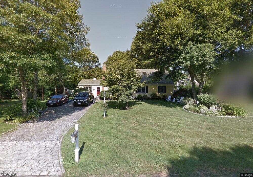
317 Skunknet Rd Centerville, MA 02632
Centerville NeighborhoodEstimated Value: $682,000 - $744,000
3
Beds
3
Baths
2,068
Sq Ft
$348/Sq Ft
Est. Value
About This Home
This home is located at 317 Skunknet Rd, Centerville, MA 02632 and is currently estimated at $719,921, approximately $348 per square foot. 317 Skunknet Rd is a home located in Barnstable County with nearby schools including West Villages Elementary School, Barnstable United Elementary School, and Barnstable Intermediate School.
Ownership History
Date
Name
Owned For
Owner Type
Purchase Details
Closed on
May 9, 1996
Sold by
Dawson D Victor and Dawson Nan W
Bought by
Ragucci Michael A
Current Estimated Value
Create a Home Valuation Report for This Property
The Home Valuation Report is an in-depth analysis detailing your home's value as well as a comparison with similar homes in the area
Home Values in the Area
Average Home Value in this Area
Purchase History
| Date | Buyer | Sale Price | Title Company |
|---|---|---|---|
| Ragucci Michael A | $107,500 | -- |
Source: Public Records
Mortgage History
| Date | Status | Borrower | Loan Amount |
|---|---|---|---|
| Open | Ragucci Michael A | $25,000 | |
| Closed | Ragucci Michael A | $30,000 | |
| Closed | Ragucci Michael A | $23,000 |
Source: Public Records
Tax History
| Year | Tax Paid | Tax Assessment Tax Assessment Total Assessment is a certain percentage of the fair market value that is determined by local assessors to be the total taxable value of land and additions on the property. | Land | Improvement |
|---|---|---|---|---|
| 2025 | $5,464 | $675,400 | $152,600 | $522,800 |
| 2024 | $5,012 | $641,700 | $152,600 | $489,100 |
| 2023 | $4,778 | $572,900 | $138,700 | $434,200 |
| 2022 | $4,553 | $472,300 | $102,700 | $369,600 |
| 2021 | $4,429 | $422,200 | $102,700 | $319,500 |
| 2020 | $4,548 | $415,000 | $102,700 | $312,300 |
| 2019 | $4,297 | $380,900 | $102,700 | $278,200 |
| 2018 | $3,901 | $347,700 | $108,200 | $239,500 |
| 2017 | $3,625 | $336,900 | $108,200 | $228,700 |
| 2016 | $3,681 | $337,700 | $109,000 | $228,700 |
| 2015 | $3,488 | $321,500 | $105,700 | $215,800 |
Source: Public Records
Map
Nearby Homes
- 493 Prince Hinckley Rd
- 172 Skunknet Rd
- 315 Prince Hinckley Rd
- 117 Elijah Childs Ln
- 38 White Oak Trail
- 136 Sheaffer Rd
- 27 Lietrim Cir
- 51 Larch Ln
- 37 Ansel Howland Rd
- 1115 Shootflying Hill Rd
- 352 Nye Rd
- 1309 Shootflying Hill Rd
- 1309 Shootflying Hill Rd
- 900 Old Stage Rd
- 169 Cedric Rd
- 52 Windlass Ln
- 47 May Ln
- 97 Yacht Club Rd
- 253 Gleneagle Dr
- 54 Rainbow Dr
- 30 Skunknet Rd
- 0 Skunknet Rd
- 325 Skunknet Rd
- 307 Skunknet Rd
- 333 Skunknet Rd
- 301 Skunknet Rd
- 312 Skunknet Rd
- 298 Stoney Cliff Rd
- 88 Zeno Crocker Rd
- 343 Skunknet Rd
- 302 Skunknet Rd
- 54 Zeno Crocker Rd
- 299 Skunknet Rd
- 291 Skunknet Rd
- 92 Zeno Crocker Rd
- 286 Stoney Cliff Rd
- 297 Stoney Cliff Rd
- 78 Zeno Crocker Rd
- 52 Zeno Crocker Rd
- 102 Zeno Crocker Rd
Your Personal Tour Guide
Ask me questions while you tour the home.