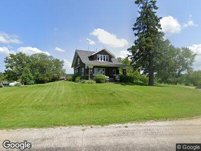
3197 Bayertown Rd SW Riverside, IA 52327
Estimated Value: $296,373 - $497,000
3
Beds
1
Bath
1,918
Sq Ft
$209/Sq Ft
Est. Value
About This Home
This home is located at 3197 Bayertown Rd SW, Riverside, IA 52327 and is currently estimated at $401,343, approximately $209 per square foot. 3197 Bayertown Rd SW is a home located in Johnson County with nearby schools including Mid-Prairie High School.
Ownership History
Date
Name
Owned For
Owner Type
Purchase Details
Closed on
Jan 2, 2015
Sold by
Bailey Thomas J and Bailey Jacqueline A
Bought by
Hochstedler Loren K and Hochstedler Elvesta R
Current Estimated Value
Create a Home Valuation Report for This Property
The Home Valuation Report is an in-depth analysis detailing your home's value as well as a comparison with similar homes in the area
Home Values in the Area
Average Home Value in this Area
Purchase History
| Date | Buyer | Sale Price | Title Company |
|---|---|---|---|
| Hochstedler Loren K | $345,000 | None Available |
Source: Public Records
Mortgage History
| Date | Status | Borrower | Loan Amount |
|---|---|---|---|
| Open | Groenewold Stephen | $70,000 | |
| Previous Owner | Groenewold Stephen P | $140,500 | |
| Previous Owner | Groenewold Stephen P | $19,900 | |
| Previous Owner | Groenewold Stephen P | $143,000 | |
| Previous Owner | Groenewold Stephen P | $40,000 | |
| Previous Owner | Groenewold Stephen P | $22,000 |
Source: Public Records
Tax History Compared to Growth
Tax History
| Year | Tax Paid | Tax Assessment Tax Assessment Total Assessment is a certain percentage of the fair market value that is determined by local assessors to be the total taxable value of land and additions on the property. | Land | Improvement |
|---|---|---|---|---|
| 2024 | $2,482 | $220,400 | $1,800 | $218,600 |
| 2023 | $3,200 | $221,800 | $1,800 | $220,000 |
| 2022 | $3,162 | $242,700 | $76,000 | $166,700 |
| 2021 | $2,306 | $242,700 | $76,000 | $166,700 |
| 2020 | $2,306 | $171,000 | $60,800 | $110,200 |
| 2019 | $2,358 | $171,000 | $60,800 | $110,200 |
| 2018 | $2,330 | $172,000 | $50,700 | $121,300 |
| 2017 | $2,330 | $172,000 | $50,700 | $121,300 |
| 2016 | $2,296 | $168,500 | $50,700 | $117,800 |
| 2015 | $2,296 | $168,500 | $50,700 | $117,800 |
| 2014 | $2,078 | $153,600 | $44,700 | $108,900 |
Source: Public Records
Map
Nearby Homes
- Maier Maier Ave SW
- 0 Maier Ave Sw at 480th St SW
- 5317 Oak Crest Hill Rd SE
- 5231 Oakcrest Hill Rd SE
- 5243 Oakcrest Hill Rd SE
- 5241 Oakcrest Hill Rd SE
- 5239 Oakcrest Hill Rd SE
- 5211 Oakcrest Hill Rd SE
- 110 Oak Crest Hill Rd SE
- 331 Knoll Ridge Dr
- 111 Oak Ridge Ave
- 321 Knoll Ridge Dr
- 311 Knoll Ridge Dr
- 2640 Iowa 22
- 300 Knoll Ridge Dr
- 261 Old Oak Ridge
- 260 Knoll Ridge Dr
- 250 Knoll Ridge Dr
- 0 Windmill Ct Unit 2501943
- 5709 Oak Crest Hill Rd SE
- 3197 Bayertown Rd SW
- 3207 Bayertown Rd SW
- 5267 Lackender Ave SW
- 3118 Bayertown Rd SW
- 3224 Bayertown Rd SW
- 5233 Lackender Ave SW
- 3249 Bayertown Rd SW
- 3239 540th St SW
- 3294 540th St SW
- 3262 Bayertown Rd SW
- 3271 Bayertown Rd SW
- 5430 Lackender Ave SW
- 3060 Bayertown Rd SW
- 3289 540th St SW
- 3040 Bayertown Rd SW
- 5464 Lackender Ave SW
- 5469 Lackender Ave SW
- 5471 Lackender Ave SW
- 3298 Bayertown Rd SW
- 3282 Bayertown Rd SW