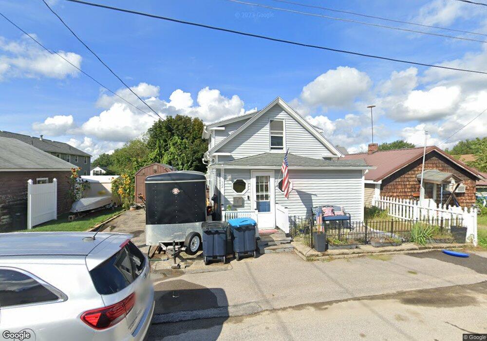
32 Cross St Allenstown, NH 03275
Suncook NeighborhoodEstimated Value: $220,000 - $354,000
1
Bed
1
Bath
1,020
Sq Ft
$278/Sq Ft
Est. Value
About This Home
This home is located at 32 Cross St, Allenstown, NH 03275 and is currently estimated at $283,496, approximately $277 per square foot. 32 Cross St is a home located in Merrimack County with nearby schools including Allenstown Elementary School, Armand R. Dupont School, and Tender Years Child Care & Learning Center.
Ownership History
Date
Name
Owned For
Owner Type
Purchase Details
Closed on
Nov 14, 2001
Sold by
454 Hanover Rlty Llc
Bought by
Day Troy A and Day Lorraine E
Current Estimated Value
Home Financials for this Owner
Home Financials are based on the most recent Mortgage that was taken out on this home.
Original Mortgage
$42,750
Interest Rate
6.7%
Purchase Details
Closed on
Feb 2, 2001
Sold by
Eastman Clifford L and Eastman Frances L
Bought by
454 Hanover Rlty Llc
Create a Home Valuation Report for This Property
The Home Valuation Report is an in-depth analysis detailing your home's value as well as a comparison with similar homes in the area
Home Values in the Area
Average Home Value in this Area
Purchase History
| Date | Buyer | Sale Price | Title Company |
|---|---|---|---|
| Day Troy A | $57,000 | -- | |
| 454 Hanover Rlty Llc | $21,000 | -- |
Source: Public Records
Mortgage History
| Date | Status | Borrower | Loan Amount |
|---|---|---|---|
| Open | 454 Hanover Rlty Llc | $136,500 | |
| Closed | 454 Hanover Rlty Llc | $42,750 |
Source: Public Records
Tax History Compared to Growth
Tax History
| Year | Tax Paid | Tax Assessment Tax Assessment Total Assessment is a certain percentage of the fair market value that is determined by local assessors to be the total taxable value of land and additions on the property. | Land | Improvement |
|---|---|---|---|---|
| 2024 | $4,131 | $162,500 | $105,900 | $56,600 |
| 2023 | $3,445 | $162,500 | $105,900 | $56,600 |
| 2022 | $3,169 | $162,500 | $105,900 | $56,600 |
| 2021 | $3,112 | $98,800 | $47,000 | $51,800 |
| 2020 | $2,895 | $98,800 | $47,000 | $51,800 |
| 2019 | $3,073 | $98,800 | $47,000 | $51,800 |
| 2018 | $2,979 | $98,800 | $47,000 | $51,800 |
| 2017 | $3,172 | $98,800 | $47,000 | $51,800 |
| 2016 | $2,658 | $78,500 | $19,200 | $59,300 |
| 2015 | $2,577 | $78,500 | $19,200 | $59,300 |
| 2014 | $2,652 | $78,500 | $19,200 | $59,300 |
| 2013 | $2,708 | $85,900 | $19,200 | $66,700 |
Source: Public Records
Map
Nearby Homes
- 422 Dawn Dr Unit 23
- 427 Dawn Dr Unit 15
- 15 Main St
- 4 Rodger Rd
- 7 Ferry St
- 111 Glass St
- 100 Main St Unit M10
- 100 Main St Unit 204
- 1 1/2 Bartlett St
- 12-14 Church St Unit 12,14
- 19 Sullivan Dr
- 10 Lane Dr
- 2 Cheryl Dr
- 15 Sullivan Dr
- 233 Pembroke St
- 307 Dearborn Rd
- 1821 Hooksett Rd
- 259 Pembroke St
- 10 Winchester Ct
- 14 Manor Dr Unit D