Estimated Value: $873,246 - $933,000
5
Beds
5
Baths
5,106
Sq Ft
$176/Sq Ft
Est. Value
About This Home
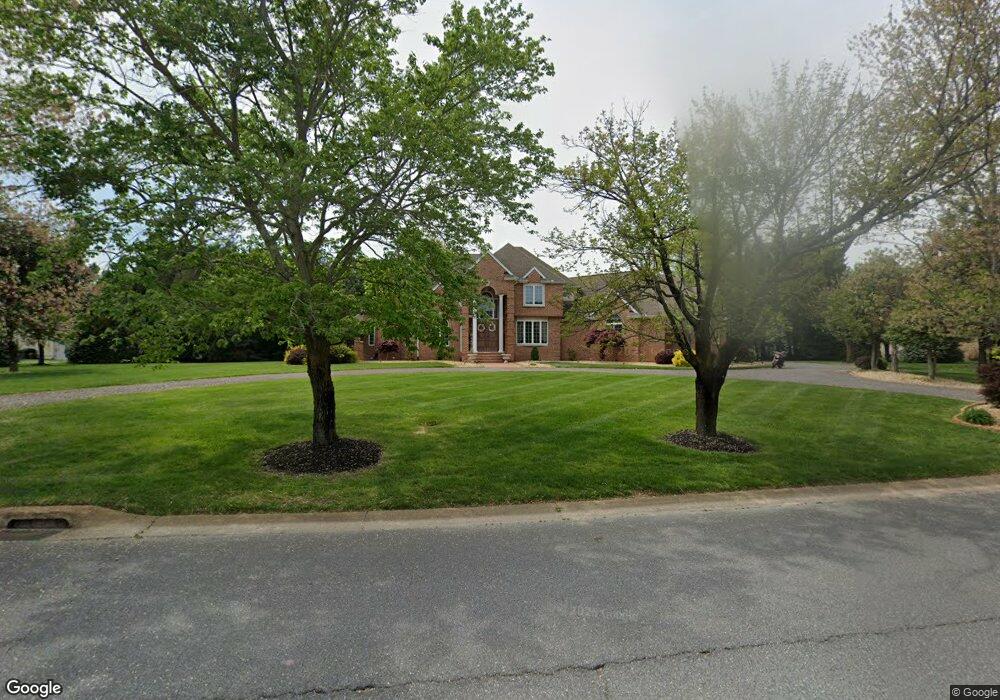
This home is located at 32 Mapledale Rd, Dover, DE 19904 and is currently estimated at $898,082, approximately $175 per square foot. 32 Mapledale Rd is a home located in Kent County with nearby schools including North Dover Elementary School, William Henry Middle School, and Central Middle School.
Ownership History
Date
Name
Owned For
Owner Type
Purchase Details
Closed on
Feb 21, 2013
Sold by
Loffreda Cosmo F and Loffreda Luisa
Bought by
Loffreda Cosmo F and Loffreda Luisa
Current Estimated Value
Home Financials for this Owner
Home Financials are based on the most recent Mortgage that was taken out on this home.
Original Mortgage
$417,000
Interest Rate
3.43%
Mortgage Type
New Conventional
Create a Home Valuation Report for This Property
The Home Valuation Report is an in-depth analysis detailing your home's value as well as a comparison with similar homes in the area
Home Values in the Area
Average Home Value in this Area
Purchase History
| Date | Buyer | Sale Price | Title Company |
|---|---|---|---|
| Loffreda Cosmo F | -- | None Available |
Source: Public Records
Mortgage History
| Date | Status | Borrower | Loan Amount |
|---|---|---|---|
| Closed | Loffreda Cosmo F | $417,000 |
Source: Public Records
Tax History
| Year | Tax Paid | Tax Assessment Tax Assessment Total Assessment is a certain percentage of the fair market value that is determined by local assessors to be the total taxable value of land and additions on the property. | Land | Improvement |
|---|---|---|---|---|
| 2025 | $5,209 | $886,400 | $187,400 | $699,000 |
| 2024 | $5,031 | $886,400 | $187,400 | $699,000 |
| 2023 | $5,872 | $199,500 | $33,500 | $166,000 |
| 2022 | $5,678 | $199,500 | $33,500 | $166,000 |
| 2021 | $5,469 | $199,500 | $33,500 | $166,000 |
| 2020 | $5,282 | $199,500 | $33,500 | $166,000 |
| 2019 | $4,993 | $199,500 | $33,500 | $166,000 |
| 2018 | $4,558 | $199,500 | $33,500 | $166,000 |
| 2017 | $4,482 | $199,500 | $0 | $0 |
| 2016 | $4,499 | $199,500 | $0 | $0 |
| 2015 | $4,495 | $199,500 | $0 | $0 |
| 2014 | $4,506 | $199,500 | $0 | $0 |
Source: Public Records
Map
Nearby Homes
- 3 Valhalla
- 5 Valhalla Ct
- 10 Valhalla Ct
- 12 Valhalla Ct
- 17 Valhalla Ct
- 35 N Turnberry Dr
- 27 N Turnberry Dr
- 28 Baltray Rd
- 11 S Turnberry Dr
- 164 Burning Tree Rd
- 138 Sweetgum Dr
- 116 Shinnecock Rd
- 235 Carnoustie Rd
- 115 Carnoustie Rd
- 108 Burning Tree Rd
- 26 Winged Foot Ct
- 42 Scioto Ct
- 24 Baltusrol Ct
- 7 Shinnecock Rd
- 271 Troon Rd
- 36 Maple Dale
- 36 Mapledale Rd Unit 2
- 36 Mapledale Rd
- 36 Maple Dale Rd
- 24 Mapledale Rd
- 24 Maple Dale Rd
- 45 Mapledale Rd
- 22 Lost Tree Ct
- 26 Lost Tree Ct
- 18 Lost Tree Ct
- 39 Mapledale Rd
- 37 Mapledale Rd
- 41 Mapledale Rd
- 35 Mapledale Rd
- 43 Mapledale Rd
- 31 Mapledale Rd
- 40 Mapledale Rd
- 29 Mapledale Rd
- 14 Lost Tree Ct
- 8 Mapledale Rd
Your Personal Tour Guide
Ask me questions while you tour the home.