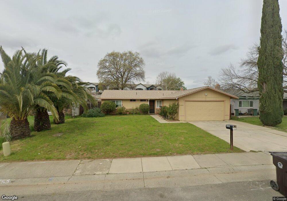
3200 Laurelhurst Dr Rancho Cordova, CA 95670
South White Rock NeighborhoodEstimated Value: $293,000 - $374,823
3
Beds
2
Baths
1,125
Sq Ft
$306/Sq Ft
Est. Value
About This Home
This home is located at 3200 Laurelhurst Dr, Rancho Cordova, CA 95670 and is currently estimated at $343,956, approximately $305 per square foot. 3200 Laurelhurst Dr is a home located in Sacramento County with nearby schools including Cordova Villa Elementary School, Mills Middle School, and Cordova High School.
Ownership History
Date
Name
Owned For
Owner Type
Purchase Details
Closed on
Mar 10, 2011
Sold by
Boyd Bobbie T and Victoria S Thomas Family Trust
Bought by
Nelson Donald A
Current Estimated Value
Home Financials for this Owner
Home Financials are based on the most recent Mortgage that was taken out on this home.
Original Mortgage
$107,211
Outstanding Balance
$76,079
Interest Rate
5.5%
Mortgage Type
FHA
Estimated Equity
$267,877
Purchase Details
Closed on
Aug 19, 2008
Sold by
Thomas Victoria S
Bought by
Thomas Victoria S and The Victoria S Thomas Family T
Purchase Details
Closed on
Apr 10, 2008
Sold by
Thomas James T
Bought by
Thomas Victoria S
Create a Home Valuation Report for This Property
The Home Valuation Report is an in-depth analysis detailing your home's value as well as a comparison with similar homes in the area
Home Values in the Area
Average Home Value in this Area
Purchase History
| Date | Buyer | Sale Price | Title Company |
|---|---|---|---|
| Nelson Donald A | $110,000 | Old Republic Title Company | |
| Thomas Victoria S | -- | None Available | |
| Thomas Victoria S | -- | None Available |
Source: Public Records
Mortgage History
| Date | Status | Borrower | Loan Amount |
|---|---|---|---|
| Open | Nelson Donald A | $107,211 |
Source: Public Records
Tax History Compared to Growth
Tax History
| Year | Tax Paid | Tax Assessment Tax Assessment Total Assessment is a certain percentage of the fair market value that is determined by local assessors to be the total taxable value of land and additions on the property. | Land | Improvement |
|---|---|---|---|---|
| 2025 | $1,733 | $140,917 | $38,430 | $102,487 |
| 2024 | $1,733 | $138,155 | $37,677 | $100,478 |
| 2023 | $1,698 | $135,447 | $36,939 | $98,508 |
| 2022 | $1,676 | $132,792 | $36,215 | $96,577 |
| 2021 | $1,643 | $130,189 | $35,505 | $94,684 |
| 2020 | $1,632 | $128,855 | $35,141 | $93,714 |
| 2019 | $1,606 | $126,329 | $34,452 | $91,877 |
| 2018 | $1,565 | $123,853 | $33,777 | $90,076 |
| 2017 | $1,526 | $121,425 | $33,115 | $88,310 |
| 2016 | $1,479 | $119,045 | $32,466 | $86,579 |
| 2015 | $1,324 | $117,258 | $31,979 | $85,279 |
| 2014 | $1,407 | $114,962 | $31,353 | $83,609 |
Source: Public Records
Map
Nearby Homes
- 10472 Abbottford Way
- 10395 S White Rock Rd Unit B
- 10276 S White Rock Rd
- 10233 Countryside Way
- 10850 Basie Way
- 10335 White Rock Rd
- 10834 Basie Way
- 10806 Basie Way
- 10035 Mills Station Rd
- 10035 Mills Station Rd Unit 60
- 10035 Mills Station Rd Unit 26
- 10035 Mills Station Rd Unit 136
- 10035 Mills Station Rd Unit 153
- 10518 Mills Acres Cir
- 102 Countess
- 50 Shrine Way
- 3478 Nut Plains Dr
- 146 Lord Way
- 60 Count Way
- 2669 Dawes St
- 3196 Laurelhurst Dr
- 3204 Laurelhurst Dr
- 3208 Laurelhurst Dr
- 3192 Laurelhurst Dr
- 10400 Autumn Breeze Way
- 3212 Laurelhurst Dr
- 3207 Laurelhurst Dr
- 10401 Autumn Breeze Way
- 10404 Autumn Breeze Way
- 3216 Laurelhurst Dr
- 3186 Laurelhurst Dr
- 3211 Laurelhurst Dr
- 10405 Autumn Breeze Way
- 3187 Laurelhurst Dr
- 10410 Reymouth Ave
- 3220 Laurelhurst Dr
- 10408 Autumn Breeze Way
- 3182 Laurelhurst Dr
- 10414 Reymouth Ave
- 3183 Laurelhurst Dr