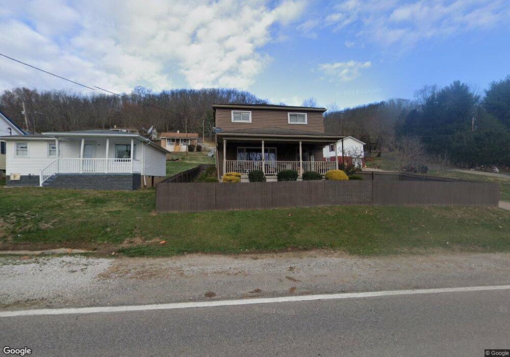
321 Highway 7 N Powhatan Point, OH 43942
Estimated Value: $143,000 - $187,000
3
Beds
2
Baths
1,538
Sq Ft
$104/Sq Ft
Est. Value
About This Home
This home is located at 321 Highway 7 N, Powhatan Point, OH 43942 and is currently estimated at $159,931, approximately $103 per square foot. 321 Highway 7 N is a home located in Belmont County with nearby schools including Powhatan Elementary School, River Elementary School, and Beallsville High School.
Ownership History
Date
Name
Owned For
Owner Type
Purchase Details
Closed on
Mar 8, 2023
Sold by
Gust Drake
Bought by
Gust Drake and Gust Christina
Current Estimated Value
Purchase Details
Closed on
Sep 17, 2021
Sold by
Rose Carissa L
Bought by
Gust Drake
Home Financials for this Owner
Home Financials are based on the most recent Mortgage that was taken out on this home.
Original Mortgage
$125,252
Interest Rate
2.8%
Mortgage Type
New Conventional
Purchase Details
Closed on
Jul 12, 2016
Sold by
Isaly Justin James and Isaly Stephanie Renae
Bought by
Rose Carissa L
Home Financials for this Owner
Home Financials are based on the most recent Mortgage that was taken out on this home.
Original Mortgage
$114,460
Interest Rate
3.66%
Mortgage Type
New Conventional
Purchase Details
Closed on
Aug 21, 2007
Sold by
Merckle Kathy S and Merckle David N
Bought by
Isaly Justin James and Isaly Stephanie Renae
Home Financials for this Owner
Home Financials are based on the most recent Mortgage that was taken out on this home.
Original Mortgage
$56,000
Interest Rate
6.77%
Mortgage Type
Unknown
Purchase Details
Closed on
Sep 6, 2006
Sold by
Merckle Karissa R and Merckle Kadrian A
Bought by
Merckle Kathy S
Purchase Details
Closed on
May 26, 2004
Sold by
Merckle Kathy S
Bought by
Merckle Kathy S
Purchase Details
Closed on
Jan 1, 1986
Sold by
Bednarczyk Frank and Bednarczyk Barbar
Bought by
Bednarczyk Frank and Bednarczyk Barbar
Create a Home Valuation Report for This Property
The Home Valuation Report is an in-depth analysis detailing your home's value as well as a comparison with similar homes in the area
Home Values in the Area
Average Home Value in this Area
Purchase History
| Date | Buyer | Sale Price | Title Company |
|---|---|---|---|
| Gust Drake | -- | -- | |
| Gust Drake | -- | None Listed On Document | |
| Gust Drake | $124,000 | None Available | |
| Gust Drake | -- | None Listed On Document | |
| Rose Carissa L | $118,000 | Attorney | |
| Isaly Justin James | $70,000 | Attorney | |
| Merckle Kathy S | -- | None Available | |
| Merckle Kathy S | -- | -- | |
| Bednarczyk Frank | -- | -- |
Source: Public Records
Mortgage History
| Date | Status | Borrower | Loan Amount |
|---|---|---|---|
| Previous Owner | Gust Drake | $125,252 | |
| Previous Owner | Rose Carissa L | $114,460 | |
| Previous Owner | Isaly Justin James | $56,000 |
Source: Public Records
Tax History Compared to Growth
Tax History
| Year | Tax Paid | Tax Assessment Tax Assessment Total Assessment is a certain percentage of the fair market value that is determined by local assessors to be the total taxable value of land and additions on the property. | Land | Improvement |
|---|---|---|---|---|
| 2024 | $1,476 | $41,670 | $2,450 | $39,220 |
| 2023 | $1,308 | $34,680 | $2,250 | $32,430 |
| 2022 | $1,334 | $34,678 | $2,247 | $32,431 |
| 2021 | $1,330 | $34,678 | $2,247 | $32,431 |
| 2020 | $1,223 | $30,150 | $1,950 | $28,200 |
| 2019 | $1,226 | $30,150 | $1,950 | $28,200 |
| 2018 | $1,273 | $30,150 | $1,950 | $28,200 |
| 2017 | $1,302 | $30,240 | $2,190 | $28,050 |
| 2016 | $1,205 | $30,240 | $2,190 | $28,050 |
| 2015 | $1,233 | $30,240 | $2,190 | $28,050 |
| 2014 | $1,064 | $27,490 | $1,990 | $25,500 |
| 2013 | $1,079 | $27,490 | $1,990 | $25,500 |
Source: Public Records
Map
Nearby Homes
- 315 Ohio 7
- 110 Cove Dr
- 0 Clark St
- 122 2nd St
- 122 3rd St
- 54885 Mount Victory Rd
- 0 Mount Victory Rd
- 54360 Mount Victory Rd
- 252 Kansas Ridge Ln
- 4390 Taylors Ridge Rd
- 9 Gypsy Dr
- 354 Clearview Heights Dr
- 21 Tharon Ln
- 53 Blue Jay Ln
- 2 Roberts Ridge Saint Joseph Rd
- 135 Windy Hollow Rd
- 49 Lavender Ln
- 85 Virginia Oaks Dr
- 56835 Stephens Rd
- 4796 Big Grave Creek Rd
- 317 Highway 7 N
- 100 Sherrie Ln
- 315 Highway 7 N
- 318 Highway 7 N
- 318 Highway 7 N
- 314 Highway 7 N
- 314 Highway 7 N
- 121 Orchard Ln
- 324 Highway 7 N
- 102 Sherrie Ln
- 310 Highway 7 N
- 115 Orchard Ln
- 104 Sherrie Ln
- 305 Highway 7 N
- 306 Highway 7 N
- 103 Sherrie Ln
- 328 Highway 7 N
- 323 Highway 7 N
- 300 Highway 7 N
- 106 Sherrie Ln