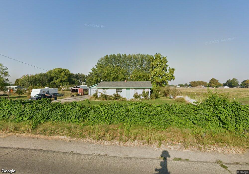
321 N Sub Station Rd Emmett, ID 83617
Gem County NeighborhoodEstimated Value: $357,000 - $433,000
3
Beds
1
Bath
1,040
Sq Ft
$383/Sq Ft
Est. Value
About This Home
This home is located at 321 N Sub Station Rd, Emmett, ID 83617 and is currently estimated at $397,839, approximately $382 per square foot. 321 N Sub Station Rd is a home located in Gem County with nearby schools including Kenneth Carberry Intermediate School and Calvary Christian Academy.
Ownership History
Date
Name
Owned For
Owner Type
Purchase Details
Closed on
Apr 14, 2021
Sold by
Brock James and Brock Stacie
Bought by
Thomas Kyle
Current Estimated Value
Home Financials for this Owner
Home Financials are based on the most recent Mortgage that was taken out on this home.
Original Mortgage
$282,500
Outstanding Balance
$254,718
Interest Rate
3.05%
Mortgage Type
New Conventional
Estimated Equity
$143,121
Purchase Details
Closed on
May 13, 2019
Sold by
Brock Jim and Brock Stacie
Bought by
Brock James and Brock Stacie
Home Financials for this Owner
Home Financials are based on the most recent Mortgage that was taken out on this home.
Original Mortgage
$100,000
Interest Rate
4.1%
Mortgage Type
New Conventional
Purchase Details
Closed on
Nov 21, 2012
Sold by
Keller Clinton D
Bought by
Brock Jim and Brock Stacie
Create a Home Valuation Report for This Property
The Home Valuation Report is an in-depth analysis detailing your home's value as well as a comparison with similar homes in the area
Home Values in the Area
Average Home Value in this Area
Purchase History
| Date | Buyer | Sale Price | Title Company |
|---|---|---|---|
| Thomas Kyle | -- | Pioneer Title Co | |
| Brock James | -- | Alliance Title Boise Product | |
| Brock Jim | -- | Alliance Title |
Source: Public Records
Mortgage History
| Date | Status | Borrower | Loan Amount |
|---|---|---|---|
| Open | Thomas Kyle | $282,500 | |
| Previous Owner | Brock James | $100,000 |
Source: Public Records
Tax History
| Year | Tax Paid | Tax Assessment Tax Assessment Total Assessment is a certain percentage of the fair market value that is determined by local assessors to be the total taxable value of land and additions on the property. | Land | Improvement |
|---|---|---|---|---|
| 2025 | $651 | $310,150 | $150,817 | $159,333 |
| 2024 | $651 | $314,454 | $163,953 | $150,501 |
| 2023 | $653 | $362,538 | $187,712 | $174,826 |
| 2021 | $752 | $264,233 | $116,418 | $147,815 |
| 2020 | $734 | $201,814 | $90,903 | $110,911 |
| 2019 | $644 | $167,281 | $56,370 | $110,911 |
| 2018 | $611 | $137,113 | $44,870 | $92,243 |
| 2017 | $655 | $121,620 | $0 | $0 |
| 2016 | $642 | $110,970 | $40,930 | $70,040 |
Source: Public Records
Map
Nearby Homes
- 1732 Sandbar Rd
- 27xx E Main St
- 1870 Meyer Ln
- 181 S Bing Ct
- 1503 Old Maple Dr
- 601 Riggs Ave
- 2589 E Jonagold Ct
- 2255 Sheri Dr
- 1309 E Main St
- 171 S Fuji Ave
- 1102 E 1st St
- 1885 Stone Dr
- 1760 Meyer Ln
- 910 Whitewater Way
- 1004 Whitewater Way
- 909 Portage Way
- TBD E Locust St
- 1733 Haystack Rd
- 1708 Rapid Rd
- 1716 Haystack Rd
- 321 N Substation Rd
- 315 N Sub Station Rd
- 360 N Substation Rd
- 318 N Sub Station Rd
- 322 N Sub Station Rd
- 316 N Sub Station Rd
- 344 N Sub Station Rd
- 1XXX N Substation Rd
- 2002 E Main St Unit SR
- 2002 E Main St
- 3 N Substation Rd
- 2 N Substation Rd
- 2 Cascade Rd
- 1886 E Main St
- 2008 E Main St
- 380 N Sub Station Rd
- 1884 E Main St
- 1732 E Main St
- 1810 E Main St
- TBD Locust
Your Personal Tour Guide
Ask me questions while you tour the home.