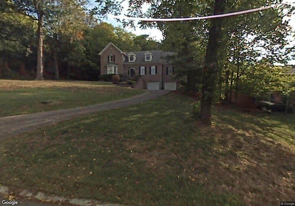
321 Saint Andrews Dr Franklin, TN 37069
Estimated Value: $935,000 - $1,333,000
--
Bed
5
Baths
3,565
Sq Ft
$324/Sq Ft
Est. Value
About This Home
This home is located at 321 Saint Andrews Dr, Franklin, TN 37069 and is currently estimated at $1,155,900, approximately $324 per square foot. 321 Saint Andrews Dr is a home located in Williamson County with nearby schools including Grassland Elementary School, Grassland Middle School, and Franklin High School.
Ownership History
Date
Name
Owned For
Owner Type
Purchase Details
Closed on
Mar 28, 2005
Sold by
Angle Brian E and Angle Marcia C
Bought by
Rivera Luis A and Rivera Kimberly J
Current Estimated Value
Home Financials for this Owner
Home Financials are based on the most recent Mortgage that was taken out on this home.
Original Mortgage
$349,600
Outstanding Balance
$176,768
Interest Rate
5.57%
Mortgage Type
Purchase Money Mortgage
Estimated Equity
$979,132
Purchase Details
Closed on
Jan 27, 1995
Sold by
Clay Livingston
Bought by
Angle Brian E
Create a Home Valuation Report for This Property
The Home Valuation Report is an in-depth analysis detailing your home's value as well as a comparison with similar homes in the area
Home Values in the Area
Average Home Value in this Area
Purchase History
| Date | Buyer | Sale Price | Title Company |
|---|---|---|---|
| Rivera Luis A | $437,000 | Realty Title & Escrow Co Inc | |
| Angle Brian E | $265,825 | -- |
Source: Public Records
Mortgage History
| Date | Status | Borrower | Loan Amount |
|---|---|---|---|
| Open | Rivera Luis A | $349,600 | |
| Closed | Rivera Luis A | $65,550 |
Source: Public Records
Tax History Compared to Growth
Tax History
| Year | Tax Paid | Tax Assessment Tax Assessment Total Assessment is a certain percentage of the fair market value that is determined by local assessors to be the total taxable value of land and additions on the property. | Land | Improvement |
|---|---|---|---|---|
| 2025 | $3,821 | $320,225 | $75,000 | $245,225 |
| 2024 | $3,821 | $203,250 | $31,250 | $172,000 |
| 2023 | $3,821 | $203,250 | $31,250 | $172,000 |
| 2022 | $3,821 | $203,250 | $31,250 | $172,000 |
| 2021 | $3,821 | $203,250 | $31,250 | $172,000 |
| 2020 | $3,550 | $159,925 | $23,750 | $136,175 |
| 2019 | $3,550 | $159,925 | $23,750 | $136,175 |
| 2018 | $3,438 | $159,925 | $23,750 | $136,175 |
| 2017 | $3,438 | $159,925 | $23,750 | $136,175 |
| 2016 | $3,438 | $159,925 | $23,750 | $136,175 |
| 2015 | -- | $133,550 | $21,250 | $112,300 |
| 2014 | -- | $133,550 | $21,250 | $112,300 |
Source: Public Records
Map
Nearby Homes
- 159 N Berwick Ln
- 230 Temple Crest Trail
- 156 N Berwick Ln
- 162 N Berwick Ln
- 6521 Stableford Ln
- 151 Baltusrol Rd
- 424 Sandcastle Rd
- 720 Wild Timber Ct
- 412 Sandcastle Rd
- 123 Saint Andrews Dr
- 6613 Hastings Ln
- 137 Timberline Dr
- 809 Sneed Rd W
- 212 Timberline Ct
- 808 Carsten St
- 917 Dauphine St
- 368 Stephens Valley Blvd
- 358 Stephens Valley Blvd
- 6105 Pasquo Rd
- St 828 GRAHAM Plan at Stephens Valley
- 317 Saint Andrews Dr
- 325 Saint Andrews Dr
- 313 Saint Andrews Dr
- 329 Saint Andrews Dr
- 322 Saint Andrews Dr
- 309 Saint Andrews Dr
- 326 Saint Andrews Dr
- 304 Bentley Ct
- 314 Saint Andrews Dr
- 333 Saint Andrews Dr
- 305 Spalding Ct
- 305 Saint Andrews Dr
- 330 Saint Andrews Dr
- 308 Spalding Ct
- 337 Saint Andrews Dr
- 404 Wexford Ct
- 404 Whitley Ct
- 309 Spalding Ct
- 301 Saint Andrews Dr
- 408 Wexford Ct