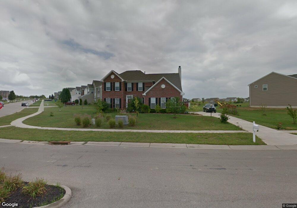
3220 Running Deer Trail Franklin, OH 45005
Estimated Value: $439,100 - $531,000
4
Beds
3
Baths
2,772
Sq Ft
$175/Sq Ft
Est. Value
About This Home
This home is located at 3220 Running Deer Trail, Franklin, OH 45005 and is currently estimated at $484,775, approximately $174 per square foot. 3220 Running Deer Trail is a home located in Warren County with nearby schools including Clearcreek Elementary School, Dennis Elementary School, and Springboro Intermediate School.
Ownership History
Date
Name
Owned For
Owner Type
Purchase Details
Closed on
Nov 17, 2005
Sold by
Nvr Inc
Bought by
Cress Gary W and Cress Olivia T
Current Estimated Value
Home Financials for this Owner
Home Financials are based on the most recent Mortgage that was taken out on this home.
Original Mortgage
$269,215
Outstanding Balance
$148,946
Interest Rate
6.2%
Mortgage Type
Fannie Mae Freddie Mac
Estimated Equity
$335,829
Purchase Details
Closed on
Aug 10, 2005
Sold by
Todd Development Co Inc
Bought by
Nvr Inc
Create a Home Valuation Report for This Property
The Home Valuation Report is an in-depth analysis detailing your home's value as well as a comparison with similar homes in the area
Home Values in the Area
Average Home Value in this Area
Purchase History
| Date | Buyer | Sale Price | Title Company |
|---|---|---|---|
| Cress Gary W | $269,233 | First Title Agency Inc | |
| Nvr Inc | $38,900 | First Title |
Source: Public Records
Mortgage History
| Date | Status | Borrower | Loan Amount |
|---|---|---|---|
| Open | Cress Gary W | $269,215 |
Source: Public Records
Tax History Compared to Growth
Tax History
| Year | Tax Paid | Tax Assessment Tax Assessment Total Assessment is a certain percentage of the fair market value that is determined by local assessors to be the total taxable value of land and additions on the property. | Land | Improvement |
|---|---|---|---|---|
| 2024 | $4,209 | $135,140 | $24,500 | $110,640 |
| 2023 | $3,583 | $108,412 | $14,455 | $93,957 |
| 2022 | $3,853 | $108,413 | $14,455 | $93,958 |
| 2021 | $3,561 | $108,413 | $14,455 | $93,958 |
| 2020 | $3,394 | $91,875 | $12,250 | $79,625 |
| 2019 | $3,413 | $91,875 | $12,250 | $79,625 |
| 2018 | $3,384 | $91,875 | $12,250 | $79,625 |
| 2017 | $3,193 | $78,694 | $10,486 | $68,208 |
| 2016 | $3,330 | $78,694 | $10,486 | $68,208 |
| 2015 | $2,924 | $78,694 | $10,486 | $68,208 |
| 2014 | $2,856 | $74,240 | $9,890 | $64,350 |
| 2013 | $3,693 | $91,940 | $12,250 | $79,690 |
Source: Public Records
Map
Nearby Homes
- Chattanooga Plan at Trails of Greycliff
- Somerset Plan at Trails of Greycliff
- Miramar Plan at Trails of Greycliff
- Carlisle Plan at Trails of Greycliff
- Birmingham Plan at Trails of Greycliff
- Rockford Plan at Trails of Greycliff
- Truman Plan at Trails of Greycliff
- Longwood Plan at Trails of Greycliff
- Sanibel Plan at Trails of Greycliff
- 3600 Yellow Finch Way
- 0 Ohio 122
- 3095 Canvasback Ct
- 3071 Canvasback Ct
- 3077 Canvasback Ct
- 3089 Canvasback Ct
- 3083 Canvasback Ct
- 3098 Canvasback Ct
- 3086 Canvasback Ct
- 3074 Canvasback Ct
- 3092 Canvasback Ct
- 3216 Running Deer Trail
- 3333 Greycliff Trail
- 3341 Greycliff Trail
- 3338 Greycliff Trail
- 3329 Greycliff Trail
- 3212 Running Deer Trail
- 3500 Morning Dove Woods
- 3703 Grey Owl Cove
- 3482 Kestrel Ct
- 3325 Greycliff Trail
- 3208 Running Deer Trail
- 3342 Greycliff Trail
- 3486 Kestrel Ct
- 3330 Greycliff Trail
- 3506 Morning Dove Woods
- 3506 Mourning Dove
- 3506 Mourning Dove Woods
- 3321 Greycliff Trail
- 3204 Running Deer Trail
- 3707 Grey Owl Cove