
Estimated payment $3,775/month
Total Views
8,839
0.87
Acre
$747,126
Price per Acre
37,897
Sq Ft Lot
Highlights
- Green Building
- Corner Lot
- No HOA
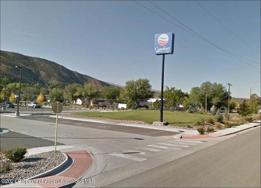
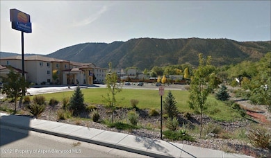
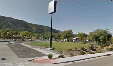
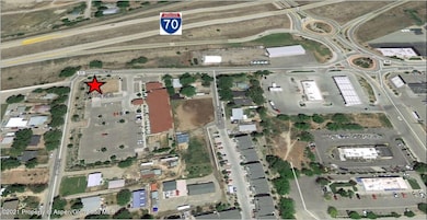
About This Lot
Corner Commercial parcel. Comfort Inn out lot. Street side curbs and gutters are in. Visible from I-70.
Last Listed By
Coldwell Banker Commercial Prime Prop. Brokerage Phone: (970) 243-7375 License #IA40011873 Listed on: 06/05/2024
Property Details
Property Type
- Land
Est. Annual Taxes
- $1,517
Lot Details
- 0.87 Acre Lot
- Corner Lot
- Property is zoned INC. CITY
Additional Features
- Green Building
- Mineral Rights Excluded
- Water Rights Not Included
Listing and Financial Details
- Property Available on 5/31/24
- Assessor Parcel Number 217716400010
Community Details
Overview
- No Home Owners Association
Recreation
- Electricity Less than 500 Feet Away
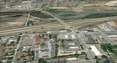
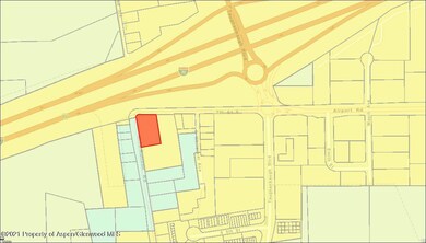
Map
Create a Home Valuation Report for This Property
The Home Valuation Report is an in-depth analysis detailing your home's value as well as a comparison with similar homes in the area
Home Values in the Area
Average Home Value in this Area
Tax History
| Year | Tax Paid | Tax Assessment Tax Assessment Total Assessment is a certain percentage of the fair market value that is determined by local assessors to be the total taxable value of land and additions on the property. | Land | Improvement |
|---|---|---|---|---|
| 2024 | $2,415 | $32,010 | $32,010 | $0 |
| 2023 | $2,415 | $32,010 | $32,010 | $0 |
| 2022 | $1,484 | $20,960 | $20,960 | $0 |
| 2021 | $1,659 | $20,960 | $20,960 | $0 |
| 2020 | $1,517 | $20,960 | $20,960 | $0 |
| 2019 | $1,434 | $20,960 | $20,960 | $0 |
| 2018 | $3,914 | $55,900 | $55,900 | $0 |
| 2017 | $5,195 | $55,900 | $55,900 | $0 |
| 2016 | $4,448 | $79,850 | $79,850 | $0 |
| 2015 | $4,107 | $79,850 | $79,850 | $0 |
| 2014 | $4,362 | $84,290 | $84,290 | $0 |
Source: Public Records
Property History
| Date | Event | Price | Change | Sq Ft Price |
|---|---|---|---|---|
| 06/05/2024 06/05/24 | For Sale | $650,000 | 0.0% | -- |
| 05/31/2024 05/31/24 | For Sale | $650,000 | 0.0% | -- |
| 04/25/2024 04/25/24 | Off Market | $650,000 | -- | -- |
| 04/23/2024 04/23/24 | Off Market | $650,000 | -- | -- |
| 09/26/2023 09/26/23 | For Sale | $650,000 | 0.0% | -- |
| 06/30/2023 06/30/23 | For Sale | $650,000 | 0.0% | -- |
| 04/24/2023 04/24/23 | Off Market | $650,000 | -- | -- |
| 04/23/2023 04/23/23 | Off Market | $650,000 | -- | -- |
| 04/28/2022 04/28/22 | For Sale | $650,000 | 0.0% | -- |
| 04/26/2022 04/26/22 | Off Market | $650,000 | -- | -- |
| 04/27/2021 04/27/21 | For Sale | $650,000 | 0.0% | -- |
| 04/23/2021 04/23/21 | For Sale | $650,000 | -- | -- |
Source: Aspen Glenwood MLS
Purchase History
| Date | Type | Sale Price | Title Company |
|---|---|---|---|
| Special Warranty Deed | $50,000 | Title365 | |
| Quit Claim Deed | -- | None Available | |
| Trustee Deed | -- | None Available | |
| Special Warranty Deed | -- | None Available | |
| Special Warranty Deed | -- | None Available | |
| Warranty Deed | $1,155,000 | Commonwealth | |
| Interfamily Deed Transfer | -- | Commonwealth | |
| Special Warranty Deed | -- | Commonwealth | |
| Warranty Deed | $1,300,000 | Commonwealth | |
| Special Warranty Deed | -- | Commonwealth | |
| Special Warranty Deed | -- | Commonwealth | |
| Warranty Deed | $850,000 | Commonwealth | |
| Quit Claim Deed | -- | None Available | |
| Interfamily Deed Transfer | -- | None Available | |
| Interfamily Deed Transfer | -- | None Available | |
| Quit Claim Deed | -- | None Available | |
| Deed | $85,000 | -- |
Source: Public Records
Mortgage History
| Date | Status | Loan Amount | Loan Type |
|---|---|---|---|
| Previous Owner | $208,000 | New Conventional | |
| Previous Owner | $595,000 | Purchase Money Mortgage | |
| Previous Owner | $248,871 | Unknown | |
| Previous Owner | $500,000 | Credit Line Revolving |
Source: Public Records
Similar Property in Rifle, CO
Source: Aspen Glenwood MLS
MLS Number: 169686
APN: R024084
Disclaimer: Certain information contained herein is derived from information provided by parties other than Homes.com. All information provided is deemed reliable, but is not guaranteed to be accurate and should be independently verified.
![]() IDX information is provided exclusively for personal, non-commercial use, and may not be used for any purpose other than to identify prospective properties consumers may be interested in purchasing. Information is deemed reliable but not guaranteed.
IDX information is provided exclusively for personal, non-commercial use, and may not be used for any purpose other than to identify prospective properties consumers may be interested in purchasing. Information is deemed reliable but not guaranteed.
Nearby Homes
- 515 Last Chance Dr
- 46 Clarkson Ave
- 216 E 1st St
- 218 E 5th St
- 500 Fairway Ave
- 756 Airport Rd
- 756 Airport Rd Unit 9 AC
- 758 Railroad Ave
- 456 County Road 294
- 125 E 9th St
- 330 Will Ave
- 450 E 10th St
- 1024 East Ave Unit 8
- Tract 1 Whiteriver Ave
- 435 Arbor Ln
- 1801 W 2nd St Unit 22
- 10467 County Road 320
- 1500 Dogwood Dr
- 1657 Dogwood Dr
- 233 County Road 265