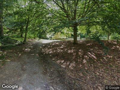
326 Parker Ln Whiteside, TN 37396
Haletown NeighborhoodEstimated Value: $116,699 - $184,000
3
Beds
1
Bath
954
Sq Ft
$164/Sq Ft
Est. Value
About This Home
This home is located at 326 Parker Ln, Whiteside, TN 37396 and is currently estimated at $156,675, approximately $164 per square foot. 326 Parker Ln is a home located in Marion County with nearby schools including Jasper Elementary School, South Pittsburg Elementary School, and Monteagle Elementary School.
Ownership History
Date
Name
Owned For
Owner Type
Purchase Details
Closed on
May 17, 2024
Sold by
Mcnabb Lorenza
Bought by
White Meghan Marie
Current Estimated Value
Home Financials for this Owner
Home Financials are based on the most recent Mortgage that was taken out on this home.
Original Mortgage
$44,366
Outstanding Balance
$44,224
Interest Rate
7.17%
Mortgage Type
New Conventional
Estimated Equity
$244,741
Purchase Details
Closed on
Mar 21, 1986
Bought by
Mcnabb Randall J
Create a Home Valuation Report for This Property
The Home Valuation Report is an in-depth analysis detailing your home's value as well as a comparison with similar homes in the area
Home Values in the Area
Average Home Value in this Area
Purchase History
| Date | Buyer | Sale Price | Title Company |
|---|---|---|---|
| White Meghan Marie | $50,000 | None Listed On Document | |
| Mcnabb Randall J | -- | -- |
Source: Public Records
Mortgage History
| Date | Status | Borrower | Loan Amount |
|---|---|---|---|
| Open | White Meghan Marie | $44,366 |
Source: Public Records
Tax History Compared to Growth
Tax History
| Year | Tax Paid | Tax Assessment Tax Assessment Total Assessment is a certain percentage of the fair market value that is determined by local assessors to be the total taxable value of land and additions on the property. | Land | Improvement |
|---|---|---|---|---|
| 2024 | $256 | $14,525 | $1,600 | $12,925 |
| 2023 | $256 | $14,525 | $0 | $0 |
| 2022 | $256 | $14,525 | $1,600 | $12,925 |
| 2021 | $256 | $14,525 | $1,600 | $12,925 |
| 2020 | $177 | $14,525 | $1,600 | $12,925 |
| 2019 | $177 | $8,175 | $1,500 | $6,675 |
| 2018 | $177 | $8,175 | $1,500 | $6,675 |
| 2017 | $177 | $8,175 | $1,500 | $6,675 |
| 2016 | $177 | $8,175 | $0 | $0 |
| 2015 | $201 | $8,175 | $0 | $0 |
| 2014 | $201 | $9,281 | $0 | $0 |
Source: Public Records
Map
Nearby Homes
- 1975 Highway 134
- 0 Tennessee 134 Unit 1396901
- 1375 Split Rail Way
- 1365 Split Rail Way
- 4273 Tennessee 134
- 1060 Birds Eye Way
- 1156 Legacy Dr
- 0 Split Rail Way Unit 1510051
- Lot 1156 Legacy Dr
- 0 Split Rail Way Unit RTC2709623
- 0 Split Rail Way Unit 1398154
- 0 Split Rail Way Unit 1397428
- 0 Split Rail Way Unit 1396389
- 0 Birds Eye Way Unit 1376127
- 1251 Mullins Point
- Lot 1251 Mullins Point
- 0 Farm Rd Unit 1506235
- 0 Farm Road #1051 Unit 1505492
- 00 Melody Dr
- 0 Constellation Ct Unit RTC2772359
