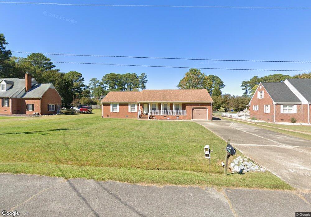
328 Carrie Dr Franklin, VA 23851
Estimated Value: $240,000 - $313,517
4
Beds
3
Baths
1,801
Sq Ft
$157/Sq Ft
Est. Value
About This Home
This home is located at 328 Carrie Dr, Franklin, VA 23851 and is currently estimated at $283,379, approximately $157 per square foot. 328 Carrie Dr is a home located in Franklin City with nearby schools including S.P. Morton Elementary School, Joseph P. King Jr. Middle School, and Franklin High School.
Ownership History
Date
Name
Owned For
Owner Type
Purchase Details
Closed on
May 7, 2025
Sold by
Denson Emma C and Denson Roy T
Bought by
Blythe Justin Dean
Current Estimated Value
Home Financials for this Owner
Home Financials are based on the most recent Mortgage that was taken out on this home.
Original Mortgage
$8,190
Outstanding Balance
$6,917
Interest Rate
6.62%
Mortgage Type
New Conventional
Estimated Equity
$276,462
Purchase Details
Closed on
Mar 28, 2008
Sold by
Drewry Carolyn P
Bought by
Rice Joan P
Create a Home Valuation Report for This Property
The Home Valuation Report is an in-depth analysis detailing your home's value as well as a comparison with similar homes in the area
Home Values in the Area
Average Home Value in this Area
Purchase History
| Date | Buyer | Sale Price | Title Company |
|---|---|---|---|
| Blythe Justin Dean | $234,000 | Stewart Title | |
| Rice Joan P | $338,200 | -- |
Source: Public Records
Mortgage History
| Date | Status | Borrower | Loan Amount |
|---|---|---|---|
| Open | Blythe Justin Dean | $8,190 | |
| Open | Blythe Justin Dean | $229,761 |
Source: Public Records
Tax History
| Year | Tax Paid | Tax Assessment Tax Assessment Total Assessment is a certain percentage of the fair market value that is determined by local assessors to be the total taxable value of land and additions on the property. | Land | Improvement |
|---|---|---|---|---|
| 2025 | $2,858 | $277,500 | $48,000 | $229,500 |
| 2024 | $2,858 | $277,500 | $48,000 | $229,500 |
| 2023 | $2,052 | $199,200 | $30,800 | $168,400 |
| 2022 | $2,052 | $199,200 | $30,800 | $168,400 |
| 2021 | $1,845 | $179,100 | $28,000 | $151,100 |
| 2020 | $1,693 | $179,100 | $28,000 | $151,100 |
| 2019 | $1,693 | $171,000 | $28,000 | $143,000 |
| 2018 | $1,693 | $171,000 | $28,000 | $143,000 |
| 2017 | $1,634 | $165,100 | $26,600 | $138,500 |
| 2016 | $1,634 | $165,100 | $26,600 | $138,500 |
| 2015 | -- | $0 | $0 | $0 |
| 2014 | -- | $0 | $0 | $0 |
| 2013 | -- | $0 | $0 | $0 |
Source: Public Records
Map
Nearby Homes
- 1121 Clay St
- 104 Hunterdale Rd
- 845 Clay St
- 105 Wynnwood Dr
- 320 Robinhood Rd
- 102 Irving St
- 105 Homestead Rd
- 133 Summit View Ln
- 241 Summit Path
- 256 Summit Path
- 210 Summit Path
- 107 Summit View Ln
- 105 Summit View Ln
- 121 Summit View Ln
- 111 Summit View Ln
- 119 Summit View Ln
- 200 Summit Path
- 216 Summit Path
- 110 Summit Path
- 104 Summit Path
- 324 Carrie Dr
- 332 Carrie Dr
- 320 Carrie Dr
- 601 Fairview Dr
- 605 Fairview Dr
- 505 Fairview Dr
- 505 Fairview Dr
- 148 Crescent Dr
- 321 Carrie Dr
- 501 Fairview Dr
- 316 Carrie Dr
- 152 Crescent Dr
- 132 Crescent Dr
- 313 Carrie Dr
- 409 Fairview Dr
- 160 Crescent Dr
- 309 Carrie Dr
- 312 Carrie Dr
- 130 Crescent Dr
- 405 Fairview Dr
Your Personal Tour Guide
Ask me questions while you tour the home.