Estimated Value: $345,000 - $417,000
3
Beds
3
Baths
2,016
Sq Ft
$193/Sq Ft
Est. Value
About This Home
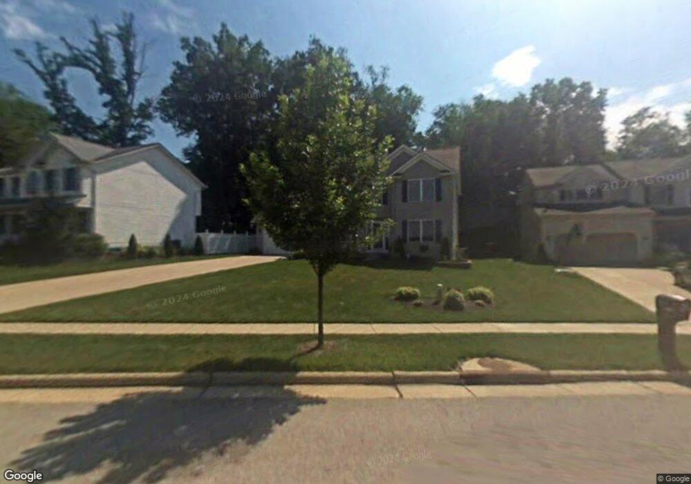
This home is located at 3281 Crown Pointe Dr, Stow, OH 44224 and is currently estimated at $389,003, approximately $192 per square foot. 3281 Crown Pointe Dr is a home located in Summit County with nearby schools including Stow-Munroe Falls High School and St Patrick Elementary School.
Ownership History
Date
Name
Owned For
Owner Type
Purchase Details
Closed on
Mar 20, 2003
Sold by
Mosley Building Corp
Bought by
Missella Christopher and Missella Julia A
Current Estimated Value
Home Financials for this Owner
Home Financials are based on the most recent Mortgage that was taken out on this home.
Original Mortgage
$164,700
Outstanding Balance
$70,184
Interest Rate
5.76%
Estimated Equity
$318,819
Purchase Details
Closed on
Sep 24, 2002
Sold by
Union Commerce Corp
Bought by
Mosley Building Corp
Home Financials for this Owner
Home Financials are based on the most recent Mortgage that was taken out on this home.
Original Mortgage
$155,000
Interest Rate
6.24%
Mortgage Type
Construction
Create a Home Valuation Report for This Property
The Home Valuation Report is an in-depth analysis detailing your home's value as well as a comparison with similar homes in the area
Home Values in the Area
Average Home Value in this Area
Purchase History
| Date | Buyer | Sale Price | Title Company |
|---|---|---|---|
| Missella Christopher | $193,845 | Land America/Lawyers Title | |
| Mosley Building Corp | $49,500 | Endress/Lawyers Title |
Source: Public Records
Mortgage History
| Date | Status | Borrower | Loan Amount |
|---|---|---|---|
| Open | Missella Christopher | $164,700 | |
| Closed | Mosley Building Corp | $155,000 |
Source: Public Records
Tax History
| Year | Tax Paid | Tax Assessment Tax Assessment Total Assessment is a certain percentage of the fair market value that is determined by local assessors to be the total taxable value of land and additions on the property. | Land | Improvement |
|---|---|---|---|---|
| 2024 | $5,615 | $99,719 | $20,717 | $79,002 |
| 2023 | $5,615 | $99,719 | $20,717 | $79,002 |
| 2022 | $5,485 | $86,062 | $17,861 | $68,201 |
| 2021 | $4,909 | $86,062 | $17,861 | $68,201 |
| 2020 | $4,825 | $86,060 | $17,860 | $68,200 |
| 2019 | $4,446 | $74,060 | $17,680 | $56,380 |
| 2018 | $4,374 | $74,060 | $17,680 | $56,380 |
| 2017 | $4,162 | $74,060 | $17,680 | $56,380 |
| 2016 | $4,284 | $68,470 | $17,680 | $50,790 |
| 2015 | $4,162 | $68,470 | $17,680 | $50,790 |
| 2014 | $4,166 | $68,470 | $17,680 | $50,790 |
| 2013 | $4,114 | $68,070 | $17,680 | $50,390 |
Source: Public Records
Map
Nearby Homes
- 3313 Crown Pointe Dr
- 1285 Gale Dr
- 1189 Garth Dr
- 350 Silver Meadows Blvd
- 884 Highridge Ln
- 895 Highridge Ln
- 458 Irma St
- 3767 Lake Run Blvd
- 957 Edgewater Cir Unit 20
- 1245 Chelton Dr
- 1330 Chelton Dr
- 3958 Lake Run Blvd
- 994 Erin Dr
- 1067 Erin Dr
- 490 Johnson Rd
- 2535 Sears Rd
- 1138 Lower Dr
- 3905 Kent Rd
- 614 Pioneer St
- 876 Middlebury Rd
- 3289 Crown Pointe Dr
- 3273 Crown Pointe Dr
- 3297 Crown Pointe Dr
- 3265 Crown Pointe Dr
- 3305 Crown Pointe Dr
- 3257 Crown Pointe Dr
- 3270 Crown Pointe Dr
- 3302 Crown Pointe Dr
- 3243 Crown Pointe Dr
- 3310 Crown Pointe Dr
- 3262 Crown Pointe Dr
- 3318 Crown Pointe Dr
- 3254 Crown Pointe Dr
- 3246 Crown Pointe Dr
- 3326 Crown Pointe Dr
- 3217 Crown Pointe Dr
- 3334 Crown Pointe Dr
- 4627 Edgewater Dr
- 3342 Crown Pointe Dr
- 4628 Edgewater Dr
Your Personal Tour Guide
Ask me questions while you tour the home.