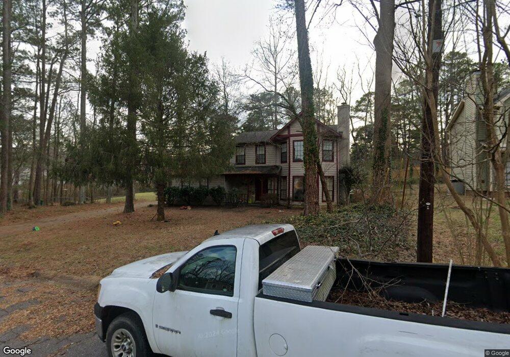
3286 Rollingbrook Way Duluth, GA 30096
Estimated Value: $382,000 - $400,000
3
Beds
3
Baths
1,892
Sq Ft
$206/Sq Ft
Est. Value
About This Home
This home is located at 3286 Rollingbrook Way, Duluth, GA 30096 and is currently estimated at $389,491, approximately $205 per square foot. 3286 Rollingbrook Way is a home located in Gwinnett County with nearby schools including B.B. Harris Elementary School, Duluth Middle School, and Duluth High School.
Ownership History
Date
Name
Owned For
Owner Type
Purchase Details
Closed on
Oct 1, 2024
Sold by
Kent Morgan L
Bought by
Galloway Morgan L and Galloway Spencer B
Current Estimated Value
Purchase Details
Closed on
Aug 16, 2016
Sold by
Daniel Louis
Bought by
Kent Morgan
Purchase Details
Closed on
Dec 9, 2013
Sold by
Blood Marcella Keating
Bought by
Kent Morgan L and Kent Daniel Louis
Home Financials for this Owner
Home Financials are based on the most recent Mortgage that was taken out on this home.
Original Mortgage
$104,000
Interest Rate
4.19%
Create a Home Valuation Report for This Property
The Home Valuation Report is an in-depth analysis detailing your home's value as well as a comparison with similar homes in the area
Home Values in the Area
Average Home Value in this Area
Purchase History
We collect this data history from publicly available records. To have your information removed, we recommend requesting removal directly through your county’s website.
| Date | Buyer | Sale Price | Title Company |
|---|---|---|---|
| Galloway Morgan L | $359,600 | -- | |
| Kent Morgan | -- | -- | |
| Kent Morgan L | $130,000 | -- |
Source: Public Records
Mortgage History
We collect this data history from publicly available records. To have your information removed, we recommend requesting removal directly through your county’s website.
| Date | Status | Borrower | Loan Amount |
|---|---|---|---|
| Previous Owner | Kent Morgan L | $104,000 |
Source: Public Records
Tax History
| Year | Tax Paid | Tax Assessment Tax Assessment Total Assessment is a certain percentage of the fair market value that is determined by local assessors to be the total taxable value of land and additions on the property. | Land | Improvement |
|---|---|---|---|---|
| 2025 | $3,996 | $161,440 | $27,880 | $133,560 |
| 2024 | $3,770 | $143,840 | $28,800 | $115,040 |
| 2023 | $3,770 | $130,000 | $22,000 | $108,000 |
| 2022 | $3,448 | $130,000 | $22,000 | $108,000 |
| 2021 | $2,706 | $92,080 | $16,000 | $76,080 |
| 2020 | $2,726 | $92,080 | $16,000 | $76,080 |
| 2019 | $2,565 | $87,040 | $14,800 | $72,240 |
| 2018 | $2,307 | $75,120 | $14,800 | $60,320 |
| 2016 | $1,836 | $61,640 | $12,000 | $49,640 |
| 2015 | $1,864 | $53,040 | $8,000 | $45,040 |
| 2014 | -- | $47,480 | $8,000 | $39,480 |
Source: Public Records
Map
Nearby Homes
- 3091 Greenstone Trail
- 3391 Blue Jay Dr
- 2830 Meadow Lark Trail
- 3366 Highland Pine Way
- 3030 Ennfield Ln
- 3518 Tracey Dr
- 3132 Pittard Hill Point
- 2702 Davenport Rd NW
- 2698 Baxter Pines Way
- 3186 Moor View #26 Rd
- 2816 Cardinal Lake Cir NW
- 3057 Orchard Ridge Cir
- 3335 Ennfield Ln
- 2832 Evanshire Ave Unit 112
- 2822 Evanshire Ave Unit 111
- 3460 Ashfield Point Ave
- 2240 Siskin Square Rd
- 3302 Monarch Ave
- 3695 Woodberry Dr
- 3434 Senna Rd
- 3296 Rollingbrook Way
- 3346 Rollingbrook Way
- 3356 Rollingbrook Way
- 3295 Rollingbrook Way
- 3275 Rollingbrook Way
- 3276 Rollingbrook Way
- 3366 Rollingbrook Way
- 3305 Rollingbrook Way
- 2962 Davenport Rd
- 3323 Star Pine Ct
- 3345 Rollingbrook Way
- 3376 Rollingbrook Way
- 2947 Nelson Dr
- 3335 Rollingbrook Way
- 3333 Star Pine Ct
- 3355 Rollingbrook Way
- 2957 Nelson Dr
- 3315 Rollingbrook Way
- 3293 Star Pine Ct
- 2937 Nelson Dr Unit 4
Your Personal Tour Guide
Ask me questions while you tour the home.