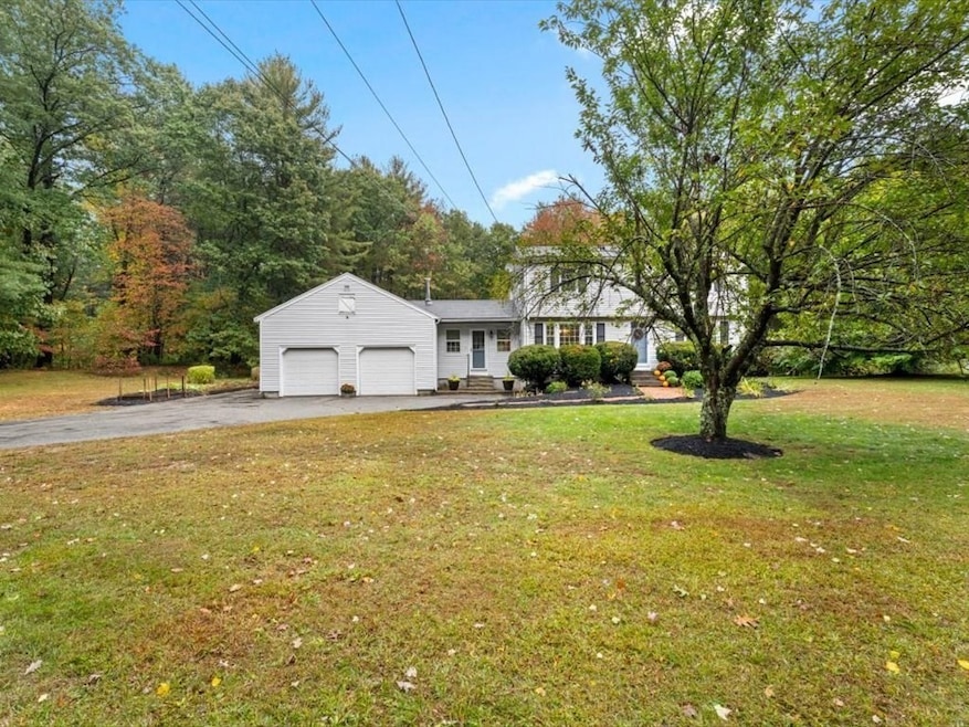
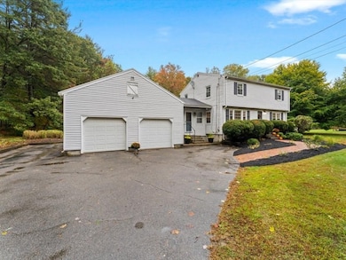
33 Daniels St Franklin, MA 02038
Estimated payment $4,504/month
Highlights
- Golf Course Community
- Community Stables
- In Ground Pool
- Helen Keller Elementary School Rated A-
- Medical Services
- Colonial Architecture
About This Home
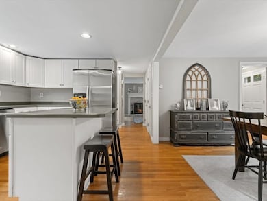
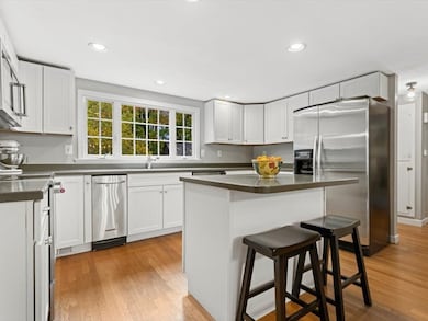
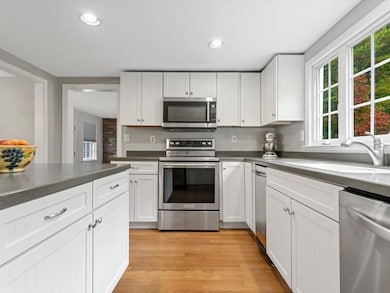
Set along a quiet country road, this home sits on 3.5 wooded acres offering a rare combination of space, privacy, and opportunity. The existing single-family home provides comfortable living today, while the property’s potential to subdivide into two additional lots presents a unique long-term investment for the future. Whether you’re looking to expand, build, or hold for future value, this is a property that gives you options. The large, updated front to back kitchen is the perfect space to host friends and family. Enjoy the tranquility of country living with the convenience of nearby town amenities including commuter rail access to Boston, restaurants and shopping. Don’t miss this rare find in Franklin — homes with this kind of potential seldom come to market.
Open House Schedule
-
Sunday, November 16, 202512:00 to 1:00 pm11/16/2025 12:00:00 PM +00:0011/16/2025 1:00:00 PM +00:00Add to Calendar
Home Details
Home Type
- Single Family
Est. Annual Taxes
- $7,556
Year Built
- Built in 1963
Lot Details
- 3.53 Acre Lot
- Wooded Lot
- Property is zoned Res 1
Parking
- 2 Car Attached Garage
- Open Parking
Home Design
- Colonial Architecture
- Garrison Architecture
- Frame Construction
- Shingle Roof
- Concrete Perimeter Foundation
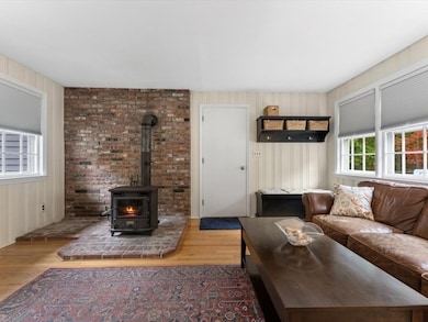
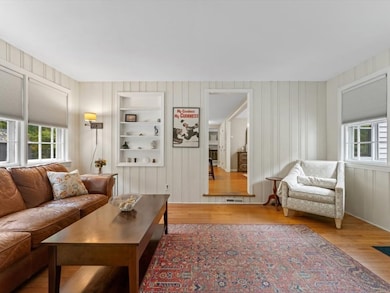
Interior Spaces
- 1,808 Sq Ft Home
- Recessed Lighting
- Wood Burning Stove
- Living Room with Fireplace
- Attic
Kitchen
- Range
- Microwave
- Dishwasher
- Stainless Steel Appliances
- Kitchen Island
- Solid Surface Countertops
Flooring
- Wood
- Ceramic Tile
- Vinyl
Bedrooms and Bathrooms
- 4 Bedrooms
- Primary bedroom located on second floor
Laundry
- Dryer
- Washer
Basement
- Basement Fills Entire Space Under The House
- Block Basement Construction
- Laundry in Basement
Outdoor Features
- In Ground Pool
- Bulkhead
- Outdoor Storage
Location
- Property is near public transit
- Property is near schools
Schools
- Lincoln Street Elementary School
- Franklin Middle School
- Franklin High School
Utilities
- Whole House Fan
- Window Unit Cooling System
- Forced Air Heating System
- 1 Heating Zone
- Heating System Uses Natural Gas
- Pellet Stove burns compressed wood to generate heat
- 200+ Amp Service
- Gas Water Heater
- Private Sewer
Listing and Financial Details
- Assessor Parcel Number M:231 L:015,95840
Community Details
Overview
- No Home Owners Association
- Near Conservation Area
Amenities
- Medical Services
- Shops
- Coin Laundry
Recreation
- Golf Course Community
- Tennis Courts
- Community Pool
- Park
- Community Stables
- Jogging Path
- Bike Trail
Map
Home Values in the Area
Average Home Value in this Area
Tax History
| Year | Tax Paid | Tax Assessment Tax Assessment Total Assessment is a certain percentage of the fair market value that is determined by local assessors to be the total taxable value of land and additions on the property. | Land | Improvement |
|---|---|---|---|---|
| 2025 | $7,556 | $650,300 | $384,400 | $265,900 |
| 2024 | $7,533 | $638,900 | $384,400 | $254,500 |
| 2023 | $7,174 | $570,300 | $327,600 | $242,700 |
| 2022 | $6,639 | $472,500 | $258,000 | $214,500 |
| 2021 | $6,783 | $463,000 | $289,800 | $173,200 |
| 2020 | $6,425 | $442,800 | $277,900 | $164,900 |
| 2019 | $6,318 | $431,000 | $266,100 | $164,900 |
| 2018 | $5,933 | $405,000 | $256,600 | $148,400 |
| 2017 | $5,628 | $386,000 | $237,600 | $148,400 |
| 2016 | $5,554 | $383,000 | $252,400 | $130,600 |
| 2015 | $5,495 | $370,300 | $239,700 | $130,600 |
| 2014 | $4,926 | $340,900 | $210,300 | $130,600 |
Property History
| Date | Event | Price | List to Sale | Price per Sq Ft |
|---|---|---|---|---|
| 10/15/2025 10/15/25 | For Sale | $735,000 | -- | $407 / Sq Ft |
Purchase History
| Date | Type | Sale Price | Title Company |
|---|---|---|---|
| Deed | $440,000 | -- |
Mortgage History
| Date | Status | Loan Amount | Loan Type |
|---|---|---|---|
| Open | $327,000 | Purchase Money Mortgage | |
| Closed | $25,000 | No Value Available |
Source: MLS Property Information Network (MLS PIN)
MLS Number: 73443646
APN: FRAN-000231-000000-000015
Disclaimer: Certain information contained herein is derived from information provided by parties other than Homes.com. All information provided is deemed reliable, but is not guaranteed to be accurate and should be independently verified.
![]() The property listing data and information, or the Images, set forth herein were provided to MLS Property Information Network, Inc. from third party sources, including sellers, lessors and public records, and were compiled by MLS Property Information Network, Inc. The property listing data and information, and the Images, are for the personal, non-commercial use of consumers having a good faith interest in purchasing or leasing listed properties of the type displayed to them and may not be used for any purpose other than to identify prospective properties which such consumers may have a good faith interest in purchasing or leasing. MLS Property Information Network, Inc. and its subscribers disclaim any and all representations and warranties as to the accuracy of the property listing data and information, or as to the accuracy of any of the Images, set forth herein.
The property listing data and information, or the Images, set forth herein were provided to MLS Property Information Network, Inc. from third party sources, including sellers, lessors and public records, and were compiled by MLS Property Information Network, Inc. The property listing data and information, and the Images, are for the personal, non-commercial use of consumers having a good faith interest in purchasing or leasing listed properties of the type displayed to them and may not be used for any purpose other than to identify prospective properties which such consumers may have a good faith interest in purchasing or leasing. MLS Property Information Network, Inc. and its subscribers disclaim any and all representations and warranties as to the accuracy of the property listing data and information, or as to the accuracy of any of the Images, set forth herein.
- 37 Daniels St
- 70 Daniels St
- 10 Silver Fox Rd
- 311 Eagles Nest Way Unit 311
- 312 Eagles Nest Way Unit 312
- 99 Leland Rd
- 484 Pleasant St
- 10 Populatic Street Extension
- 8 Meadowlark Ln
- 41 Myrtle St
- 91 Oliver Pond Cir Unit 3
- 83 Oliver Pond Cir Unit 7
- 48 Leanne Way Unit 48
- 21 Winterberry Dr
- 324 Pleasant St
- 12 Ariana Ln
- 266 Pleasant St
- 732 Lincoln St
- 734 Lincoln St
- 0 Toils End Rd
- 117 Dean Ave
- 300 Glen Meadow Rd
- 125 Main St Unit 1
- 139 E Central St Unit 2
- 1-8 Gatehouse Ln
- 330 E Central St
- 146 Village St Unit 3
- 12 Uncas Ave Unit 11
- 28 Church Ave Unit 2
- 1410 Franklin Crossing Rd
- 809 Franklin Crossing Rd Unit 809
- 301 Union St
- 5 Eagle Brook Blvd Unit 105
- 5 Eagle Brook Blvd Unit 81
- 5 Eagle Brook Blvd Unit 125
- 5 Eagle Brook Blvd Unit 95
- 656 Franklin St
- 39 Main St
- 12 Hawthorne Village Unit C
- 15 Hawthorne Village Unit D
