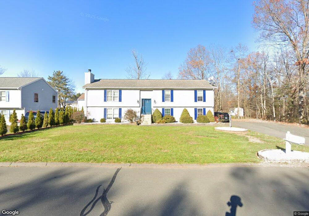
33 Rutledge Rd Wethersfield, CT 06109
Estimated Value: $437,000 - $530,239
3
Beds
3
Baths
1,763
Sq Ft
$276/Sq Ft
Est. Value
About This Home
This home is located at 33 Rutledge Rd, Wethersfield, CT 06109 and is currently estimated at $486,810, approximately $276 per square foot. 33 Rutledge Rd is a home located in Hartford County with nearby schools including Emerson-Williams School, Silas Deane Middle School, and Wethersfield High School.
Ownership History
Date
Name
Owned For
Owner Type
Purchase Details
Closed on
Nov 14, 2024
Sold by
Caushi Arjanita
Bought by
Caushi Ermal
Current Estimated Value
Purchase Details
Closed on
Feb 3, 2015
Sold by
Krupiczka Caushi K
Bought by
Caushi Ermal
Purchase Details
Closed on
Jul 22, 2014
Sold by
Erturkmen Sarik and Mati Urana
Bought by
Caushi Ermal and Caushi Krupiczka-Caushi K
Purchase Details
Closed on
May 16, 2008
Sold by
Jaminet Mark T and Jaminet Patricia D
Bought by
Erturkmen Sarik and Mati Urana
Purchase Details
Closed on
Dec 1, 2003
Sold by
Caliolo Robert M and Caliolo Judith A
Bought by
Jaminet Mark T and Jaminet Patricia D
Create a Home Valuation Report for This Property
The Home Valuation Report is an in-depth analysis detailing your home's value as well as a comparison with similar homes in the area
Home Values in the Area
Average Home Value in this Area
Purchase History
| Date | Buyer | Sale Price | Title Company |
|---|---|---|---|
| Caushi Ermal | -- | None Available | |
| Caushi Ermal | -- | None Available | |
| Caushi Ermal | -- | -- | |
| Caushi Ermal | $233,600 | -- | |
| Erturkmen Sarik | $298,500 | -- | |
| Jaminet Mark T | $250,000 | -- | |
| Caushi Ermal | -- | -- | |
| Caushi Ermal | $233,600 | -- | |
| Erturkmen Sarik | $298,500 | -- | |
| Jaminet Mark T | $250,000 | -- |
Source: Public Records
Mortgage History
| Date | Status | Borrower | Loan Amount |
|---|---|---|---|
| Previous Owner | Jaminet Mark T | $110,000 | |
| Previous Owner | Jaminet Mark T | $71,000 |
Source: Public Records
Tax History
| Year | Tax Paid | Tax Assessment Tax Assessment Total Assessment is a certain percentage of the fair market value that is determined by local assessors to be the total taxable value of land and additions on the property. | Land | Improvement |
|---|---|---|---|---|
| 2025 | $13,277 | $322,090 | $69,970 | $252,120 |
| 2024 | $8,986 | $207,910 | $71,380 | $136,530 |
| 2023 | $8,686 | $207,910 | $71,380 | $136,530 |
| 2022 | $8,541 | $207,910 | $71,380 | $136,530 |
| 2021 | $8,456 | $207,910 | $71,380 | $136,530 |
| 2020 | $8,460 | $207,910 | $71,380 | $136,530 |
| 2019 | $8,470 | $207,910 | $71,380 | $136,530 |
| 2018 | $8,372 | $205,300 | $70,100 | $135,200 |
| 2017 | $8,165 | $205,300 | $70,100 | $135,200 |
| 2016 | $7,912 | $205,300 | $70,100 | $135,200 |
| 2015 | $7,840 | $205,300 | $70,100 | $135,200 |
| 2014 | $7,543 | $205,300 | $70,100 | $135,200 |
Source: Public Records
Map
Nearby Homes
- 192 Wolcott Hill Rd
- 1 Bristol St
- 295 Ridge Rd Unit 8
- 19 Albert Ave
- 764 Ridge Rd
- 20 Forest Dr
- 158 Dix Rd
- 23 Hillcrest Ave
- 273 Forest Dr
- 219-221 Jordan Ln
- 173 Timber Trail
- 87 Somerset St
- 91 Somerset St
- 137 Dale Rd
- 129 Goff Rd
- 35 Stillwold Dr
- 455 Brimfield Rd
- 1 Fernwood St
- 18 Avalon Place
- 35 Kingston St
Your Personal Tour Guide
Ask me questions while you tour the home.