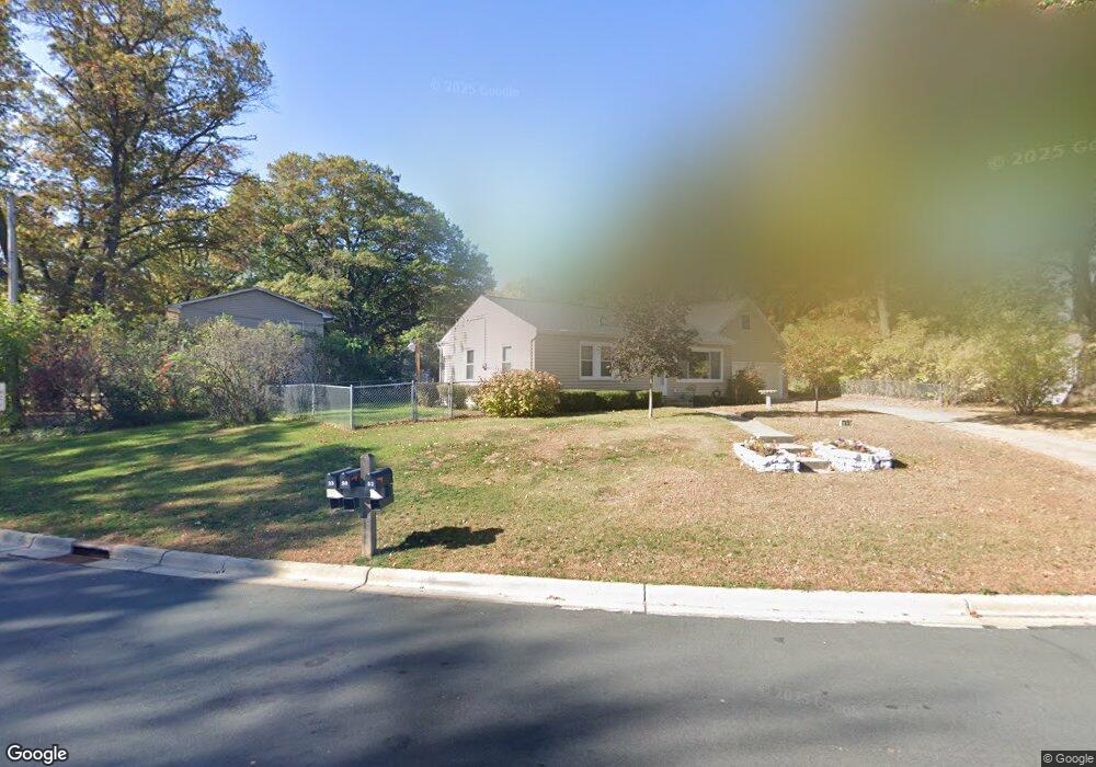
33 West Rd Circle Pines, MN 55014
Estimated Value: $243,027 - $280,000
3
Beds
1
Bath
864
Sq Ft
$301/Sq Ft
Est. Value
About This Home
This home is located at 33 West Rd, Circle Pines, MN 55014 and is currently estimated at $260,007, approximately $300 per square foot. 33 West Rd is a home located in Anoka County with nearby schools including Centennial Elementary School, Centennial Middle School, and Centennial High School.
Ownership History
Date
Name
Owned For
Owner Type
Purchase Details
Closed on
Nov 26, 2012
Sold by
City Of Circle Pines
Bought by
Hallis Samuel Lee and Hallis Claudia Ann
Current Estimated Value
Purchase Details
Closed on
Oct 16, 2000
Sold by
Peske Paul and Peske Brenda
Bought by
Hallis Samual L and Hallis Claudia A
Create a Home Valuation Report for This Property
The Home Valuation Report is an in-depth analysis detailing your home's value as well as a comparison with similar homes in the area
Home Values in the Area
Average Home Value in this Area
Purchase History
| Date | Buyer | Sale Price | Title Company |
|---|---|---|---|
| Hallis Samuel Lee | -- | None Available | |
| Hallis Samual L | $107,900 | -- |
Source: Public Records
Tax History
| Year | Tax Paid | Tax Assessment Tax Assessment Total Assessment is a certain percentage of the fair market value that is determined by local assessors to be the total taxable value of land and additions on the property. | Land | Improvement |
|---|---|---|---|---|
| 2025 | $2,469 | $231,800 | $110,000 | $121,800 |
| 2024 | $2,469 | $215,200 | $95,000 | $120,200 |
| 2023 | $2,810 | $219,200 | $98,200 | $121,000 |
| 2022 | $2,623 | $207,200 | $82,000 | $125,200 |
| 2021 | $2,573 | $168,000 | $64,400 | $103,600 |
| 2020 | $2,709 | $162,900 | $64,400 | $98,500 |
| 2019 | $2,584 | $164,000 | $61,300 | $102,700 |
| 2018 | $2,350 | $148,300 | $0 | $0 |
| 2017 | $2,086 | $144,500 | $0 | $0 |
| 2016 | $2,051 | $118,800 | $0 | $0 |
| 2015 | $1,953 | $118,800 | $47,000 | $71,800 |
| 2014 | -- | $0 | $0 | $0 |
Source: Public Records
Map
Nearby Homes
- 5 Cameo Ln Unit D
- 714 Village Pkwy
- 306 Heritage Trail
- 343 Heritage Trail
- 330 Heritage Trail Unit 117
- 9991 Cord St NE
- 4185 Austin St NE
- 4145 Austin St NE
- 3975 Lovell Rd
- 9105 Lexington Ave N Unit B
- 104 South Dr Unit B
- 10216 Erskin St NE
- 110 South Dr
- 9052 Jackson Ave
- 9016 Jackson Ave
- 215 Keith Rd
- 8 Pointcross Dr
- 4842 104th Ave NE
- 4831 104th Ln NE
- 4841 105th Ln NE
Your Personal Tour Guide
Ask me questions while you tour the home.