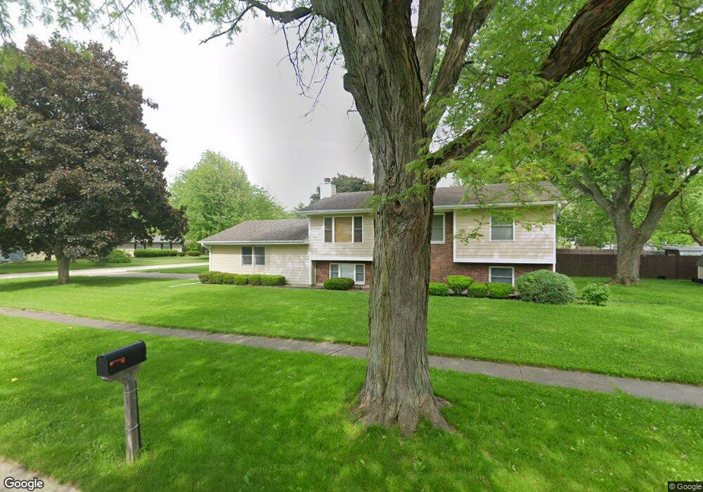
330 Forest Ave Oswego, IL 60543
Downtown Oswego NeighborhoodEstimated Value: $299,000 - $322,000
3
Beds
2
Baths
1,096
Sq Ft
$288/Sq Ft
Est. Value
About This Home
This home is located at 330 Forest Ave, Oswego, IL 60543 and is currently estimated at $315,195, approximately $287 per square foot. 330 Forest Ave is a home located in Kendall County with nearby schools including Southbury Elementary School, Traughber Junior High School, and Oswego High School.
Ownership History
Date
Name
Owned For
Owner Type
Purchase Details
Closed on
Nov 24, 1999
Sold by
Carlson Kenneth H and Carlson Sharon M
Bought by
Neal Heather L and Channell Jeffery A
Current Estimated Value
Home Financials for this Owner
Home Financials are based on the most recent Mortgage that was taken out on this home.
Original Mortgage
$132,427
Outstanding Balance
$40,800
Interest Rate
7.87%
Mortgage Type
FHA
Estimated Equity
$274,395
Purchase Details
Closed on
Mar 1, 1990
Bought by
S Carlson K and S M
Purchase Details
Closed on
Sep 1, 1988
Purchase Details
Closed on
Aug 1, 1985
Create a Home Valuation Report for This Property
The Home Valuation Report is an in-depth analysis detailing your home's value as well as a comparison with similar homes in the area
Home Values in the Area
Average Home Value in this Area
Purchase History
| Date | Buyer | Sale Price | Title Company |
|---|---|---|---|
| Neal Heather L | $137,000 | First American Title Ins Co | |
| S Carlson K | $105,000 | -- | |
| -- | $108,000 | -- | |
| -- | -- | -- |
Source: Public Records
Mortgage History
| Date | Status | Borrower | Loan Amount |
|---|---|---|---|
| Open | Neal Heather L | $132,427 | |
| Closed | S Carlson K | -- |
Source: Public Records
Tax History
| Year | Tax Paid | Tax Assessment Tax Assessment Total Assessment is a certain percentage of the fair market value that is determined by local assessors to be the total taxable value of land and additions on the property. | Land | Improvement |
|---|---|---|---|---|
| 2024 | $6,937 | $92,207 | $20,900 | $71,307 |
| 2023 | $6,162 | $80,180 | $18,174 | $62,006 |
| 2022 | $6,162 | $74,241 | $16,828 | $57,413 |
| 2021 | $5,931 | $69,384 | $15,727 | $53,657 |
| 2020 | $5,798 | $67,363 | $15,269 | $52,094 |
| 2019 | $5,702 | $65,402 | $14,825 | $50,577 |
| 2018 | $5,751 | $65,402 | $14,825 | $50,577 |
| 2017 | $5,564 | $60,279 | $13,664 | $46,615 |
| 2016 | $5,319 | $57,137 | $12,952 | $44,185 |
| 2015 | $5,339 | $54,940 | $12,454 | $42,486 |
| 2014 | -- | $52,827 | $11,975 | $40,852 |
| 2013 | -- | $55,028 | $12,474 | $42,554 |
Source: Public Records
Map
Nearby Homes
- 429 Prairieview Dr
- 371 S Madison St
- 206 E Washington St
- 268 S Adams St
- 69 Monroe St
- 395 Danforth Dr
- 238 Cooney Way
- 239 Cooney Way
- 403 Tanya Ln
- 343 Danforth Dr
- 713 Erwin St
- 236 Cooney Way
- 237 Cooney Way
- 55 Garfield St
- 101 Bell Ct
- 114 Riverview Ct
- 514 Danbury Dr Unit 4
- 187 Eisenhower Dr
- 117 Presidential Blvd Unit 3244
- 1451 Vintage Dr
- 131 Locust St
- 123 Locust St
- 339 Forest Ave
- 136 Hickory St
- 325 Forest Ave
- 317 Forest Ave Unit 3
- 306 Forest Ave
- 128 Hickory St
- 115 Locust St
- 134 Locust St
- 204 Hickory St
- 309 Forest Ave
- 120 Hickory St
- 107 Locust St
- 407 Forest Ave
- 310 Monroe St Unit 4
- 212 Hickory St
- 264 Forest Ave
- 318 Monroe St
- 301 Forest Ave
Your Personal Tour Guide
Ask me questions while you tour the home.