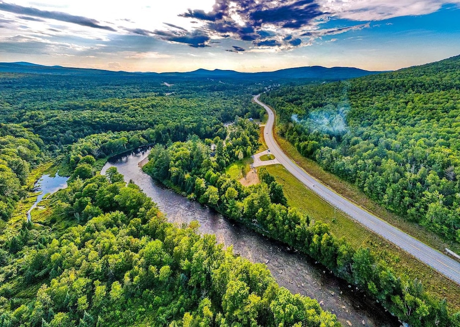
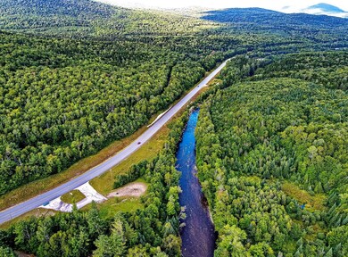
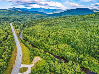


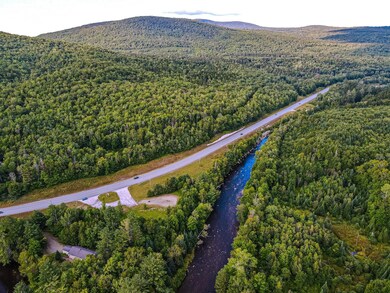
330 Us Route 302 Route E Carroll, NH 03598
Estimated payment $4,116/month
Highlights
- Deeded Waterfront Access Rights
- Mountain View
- Wooded Lot
- 665 Feet of Waterfront
- Stream or River on Lot
- Trails
About This Lot
Extraordinary, 'One of a Kind' Land Parcel. The Gateway to Bretton Woods. Ammonoosuc River Frontage, White Mountain Views and the White Mountain National Forest for a neighbor, this 2.68 +- acre former restaurant site has a history of serving the tourism industry. Once home to a riverfront rental business, then a general store and most recently the Mooseland Grill, the potential is unsurpassed. Frontage on RT 302, the major East / West route in Northern NH, gives excellent exposure with an ever increasing traffic count. With over 600 feet of RT 302 frontage and two established entrances into the site, the ground work has been started; additionally, there is 'Rare', River frontage of 665 feet. Zoned Residential / Business; Property Class: Commercial. Environmental Site Assessment and potential plaza/ building configurations done in 2007.
Last Listed By
Coldwell Banker LIFESTYLES- Franconia Brokerage Phone: 603-986-8389 License #060026 Listed on: 11/07/2023

Property Details
Property Type
- Land
Est. Annual Taxes
- $2,533
Lot Details
- 2.68 Acre Lot
- 665 Feet of Waterfront
- River Front
- Open Lot
- Lot Sloped Up
- Wooded Lot
- Property is zoned Res - Business
Property Views
- Mountain Views
Schools
- Whitefield Elementary School
- Whitefield Elementary Middle School
- White Mountain Regional High School
Utilities
- Septic Tank
- Internet Available
Community Details
- Trails
- Deeded Waterfront Access Rights
- Nearby Water Access
- Electricity Available at Street
- Stream or River on Lot
Listing and Financial Details
- Legal Lot and Block 3 / 18
Map
Home Values in the Area
Average Home Value in this Area
Tax History
| Year | Tax Paid | Tax Assessment Tax Assessment Total Assessment is a certain percentage of the fair market value that is determined by local assessors to be the total taxable value of land and additions on the property. | Land | Improvement |
|---|---|---|---|---|
| 2024 | $2,266 | $190,400 | $190,400 | $0 |
| 2023 | $2,348 | $190,400 | $190,400 | $0 |
| 2022 | $2,308 | $190,400 | $190,400 | $0 |
| 2021 | $1,859 | $97,200 | $97,200 | $0 |
| 2020 | $2,066 | $97,200 | $97,200 | $0 |
| 2019 | $1,944 | $97,200 | $97,200 | $0 |
| 2018 | $1,914 | $97,200 | $97,200 | $0 |
| 2015 | $2,249 | $118,200 | $118,200 | $0 |
| 2011 | $2,819 | $208,040 | $208,040 | $0 |
Property History
| Date | Event | Price | Change | Sq Ft Price |
|---|---|---|---|---|
| 11/20/2024 11/20/24 | Price Changed | $699,000 | -28.5% | -- |
| 11/20/2024 11/20/24 | For Sale | $977,500 | 0.0% | -- |
| 11/07/2024 11/07/24 | Off Market | $977,500 | -- | -- |
| 11/07/2023 11/07/23 | For Sale | $977,500 | -- | -- |
Purchase History
| Date | Type | Sale Price | Title Company |
|---|---|---|---|
| Warranty Deed | $225,000 | -- | |
| Warranty Deed | $240,000 | -- |
Mortgage History
| Date | Status | Loan Amount | Loan Type |
|---|---|---|---|
| Previous Owner | $50,000 | Purchase Money Mortgage |
Source: PrimeMLS
MLS Number: 4977278
APN: CARR-000418-000018-000003
Disclaimer: Certain information contained herein is derived from information provided by parties other than Homes.com. All information provided is deemed reliable, but is not guaranteed to be accurate and should be independently verified.
![]() Copyright 2025 PrimeMLS, Inc. All rights reserved. This information is deemed reliable, but not guaranteed. The data relating to real estate displayed on this display comes in part from the IDX Program of PrimeMLS. The information being provided is for consumers’ personal, non-commercial use and may not be used for any purpose other than to identify prospective properties consumers may be interested in purchasing.
Copyright 2025 PrimeMLS, Inc. All rights reserved. This information is deemed reliable, but not guaranteed. The data relating to real estate displayed on this display comes in part from the IDX Program of PrimeMLS. The information being provided is for consumers’ personal, non-commercial use and may not be used for any purpose other than to identify prospective properties consumers may be interested in purchasing.
- 330 Us Route 302 Route E
- 144 Grandpa Harry's Ln
- 00 Route 115
- 0 Route 115 Unit 5036498
- 0 Route 115 Unit 5036490
- 170 S Whitefield Rd
- 0 Route 115 Unit 4976327
- 59 Parker Rd
- 00 Beechwood Dr
- 53 Jefferson Rd
- 0 Twin View Dr Unit 5039710
- 69 Twin View Dr
- 599 Littleton Rd
- 5 Forest Ln Unit 48
- 0 Jefferson Rd Unit 5038451
- 9 Laurel St
- 75 Elm St
- 224 U S 302
- 155 Mountain View Rd
- 190 Lancaster Rd