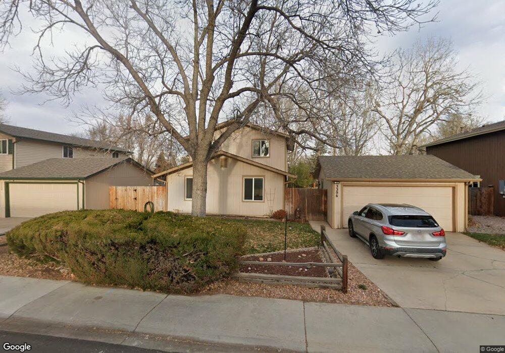
3306 Birmingham Dr Fort Collins, CO 80526
Estimated Value: $519,620 - $524,000
3
Beds
2
Baths
1,680
Sq Ft
$311/Sq Ft
Est. Value
About This Home
This home is located at 3306 Birmingham Dr, Fort Collins, CO 80526 and is currently estimated at $521,655, approximately $310 per square foot. 3306 Birmingham Dr is a home located in Larimer County with nearby schools including Johnson Elementary School, Webber Middle School, and Rocky Mountain High School.
Ownership History
Date
Name
Owned For
Owner Type
Purchase Details
Closed on
Sep 17, 2007
Sold by
Murray Eileen M and Murray Edward P
Bought by
Gibson Bonnie K
Current Estimated Value
Home Financials for this Owner
Home Financials are based on the most recent Mortgage that was taken out on this home.
Original Mortgage
$176,800
Outstanding Balance
$111,420
Interest Rate
6.48%
Mortgage Type
Purchase Money Mortgage
Estimated Equity
$410,235
Purchase Details
Closed on
Mar 1, 1989
Bought by
Murray Eileen M and Murray Edward P
Create a Home Valuation Report for This Property
The Home Valuation Report is an in-depth analysis detailing your home's value as well as a comparison with similar homes in the area
Home Values in the Area
Average Home Value in this Area
Purchase History
| Date | Buyer | Sale Price | Title Company |
|---|---|---|---|
| Gibson Bonnie K | $208,000 | None Available | |
| Murray Eileen M | $68,500 | -- |
Source: Public Records
Mortgage History
| Date | Status | Borrower | Loan Amount |
|---|---|---|---|
| Open | Gibson Bonnie K | $176,800 |
Source: Public Records
Tax History Compared to Growth
Tax History
| Year | Tax Paid | Tax Assessment Tax Assessment Total Assessment is a certain percentage of the fair market value that is determined by local assessors to be the total taxable value of land and additions on the property. | Land | Improvement |
|---|---|---|---|---|
| 2025 | $2,922 | $34,137 | $2,680 | $31,457 |
| 2024 | $2,780 | $34,137 | $2,680 | $31,457 |
| 2022 | $2,382 | $25,222 | $2,780 | $22,442 |
| 2021 | $2,407 | $25,947 | $2,860 | $23,087 |
| 2020 | $2,459 | $26,283 | $2,860 | $23,423 |
| 2019 | $2,470 | $26,283 | $2,860 | $23,423 |
| 2018 | $1,928 | $21,154 | $2,880 | $18,274 |
| 2017 | $1,921 | $21,154 | $2,880 | $18,274 |
| 2016 | $1,597 | $17,496 | $3,184 | $14,312 |
| 2015 | $1,586 | $17,490 | $3,180 | $14,310 |
| 2014 | $1,421 | $15,580 | $3,180 | $12,400 |
Source: Public Records
Map
Nearby Homes
- 1819 Birmingham Dr
- 3366 Liverpool St
- 2025 Cheshire St
- 3136 Birmingham Dr
- 2 County Road 19
- 1631 Enfield St
- 3502 Big Ben Dr Unit C
- 3622 Capitol Dr
- 1531 W Swallow Rd Unit 28
- 1531 W Swallow Rd Unit 25
- 1601 W Swallow Rd Unit 9
- 1601 W Swallow Rd Unit 1
- 1601 W Swallow Rd
- 2855 Trenton Way
- 1401 Sioux Blvd
- 1526 Corydalis Ct
- 1539 Corydalis Ct
- 1401 Sanford Dr
- 3717 S Taft Hill Rd Unit 279
- 3717 S Taft Hill Rd Unit 111
- 3300 Birmingham Dr
- 3312 Birmingham Dr
- 3230 Birmingham Dr
- 3318 Birmingham Dr
- 3313 Kittery Ct
- 1901 Derby Ct
- 1900 Newcastle Ct
- 3224 Birmingham Dr
- 3324 Birmingham Dr
- 3319 Kittery Ct
- 3307 Kittery Ct
- 1906 Newcastle Ct
- 1900 Derby Ct
- 1907 Derby Ct
- 3301 Kittery Ct
- 3349 Dunbar Ave
- 3218 Birmingham Dr
- 3330 Birmingham Dr
- 3325 Birmingham Dr
- 3343 Dunbar Ave