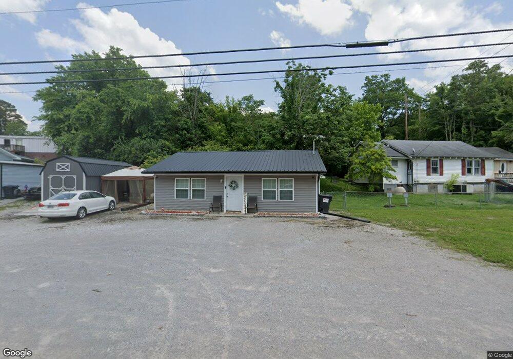
3325 Highway 61 E Luttrell, TN 37779
Estimated Value: $150,451
2
Beds
2
Baths
896
Sq Ft
$168/Sq Ft
Est. Value
About This Home
This home is located at 3325 Highway 61 E, Luttrell, TN 37779 and is currently estimated at $150,451, approximately $167 per square foot. 3325 Highway 61 E is a home located in Union County with nearby schools including Luttrell Elementary School, H Maynard Middle School, and Union County High School.
Ownership History
Date
Name
Owned For
Owner Type
Purchase Details
Closed on
Jul 26, 2024
Sold by
Merritt Derrick A and Merritt Scarlett
Bought by
Merritt Presley Sierra
Current Estimated Value
Home Financials for this Owner
Home Financials are based on the most recent Mortgage that was taken out on this home.
Original Mortgage
$129,731
Outstanding Balance
$127,936
Interest Rate
6.95%
Mortgage Type
Credit Line Revolving
Estimated Equity
$22,515
Purchase Details
Closed on
Oct 10, 2006
Bought by
Kitts Mitchell Kitts Gloria K
Purchase Details
Closed on
Nov 4, 2003
Bought by
Kitts Mitchell Kitts Gloria K
Purchase Details
Closed on
Mar 10, 1987
Purchase Details
Closed on
Oct 18, 1984
Bought by
Hill Billie R
Create a Home Valuation Report for This Property
The Home Valuation Report is an in-depth analysis detailing your home's value as well as a comparison with similar homes in the area
Home Values in the Area
Average Home Value in this Area
Purchase History
| Date | Buyer | Sale Price | Title Company |
|---|---|---|---|
| Merritt Presley Sierra | $150,000 | Cardinal Title | |
| Kitts Mitchell Kitts Gloria K | $33,000 | -- | |
| Kitts Mitchell Kitts Gloria K | $33,000 | -- | |
| Kitts Mitchell Kitts Gloria K | $35,000 | -- | |
| Kitts Mitchell Kitts Gloria K | $35,000 | -- | |
| -- | $10,000 | -- | |
| -- | $10,000 | -- | |
| Hill Billie R | -- | -- | |
| Hill Billie R | -- | -- |
Source: Public Records
Mortgage History
| Date | Status | Borrower | Loan Amount |
|---|---|---|---|
| Open | Merritt Presley Sierra | $129,731 |
Source: Public Records
Tax History
| Year | Tax Paid | Tax Assessment Tax Assessment Total Assessment is a certain percentage of the fair market value that is determined by local assessors to be the total taxable value of land and additions on the property. | Land | Improvement |
|---|---|---|---|---|
| 2025 | $214 | $11,250 | $2,875 | $8,375 |
| 2024 | $214 | $11,250 | $2,875 | $8,375 |
| 2023 | $214 | $11,250 | $2,875 | $8,375 |
| 2022 | $179 | $11,250 | $2,875 | $8,375 |
| 2021 | $225 | $10,525 | $2,350 | $8,175 |
| 2020 | $225 | $10,525 | $2,350 | $8,175 |
| 2019 | $225 | $10,525 | $2,350 | $8,175 |
| 2018 | $225 | $10,525 | $2,350 | $8,175 |
| 2017 | $225 | $10,525 | $2,350 | $8,175 |
| 2016 | $203 | $9,375 | $2,350 | $7,025 |
| 2015 | $203 | $9,375 | $2,350 | $7,025 |
| 2014 | $168 | $9,374 | $0 | $0 |
Source: Public Records
Map
Nearby Homes
- 3243 Highway 61 E
- 3528 Highway 61 E
- 3002 Highway 61 E
- 0 Wolfenbarger Tract 1 Unit 1294792
- 0 Tazewell Pike Unit 1312170
- 738 & 742 Archer Rd
- 295 Archer Rd
- 1617 Bull Run Rd
- 204 Archer Rd
- 417 Wolfe Rd
- 259 Little Tater Valley Rd
- 295 Clear Branch Rd
- 388 Damewood Hollow Rd
- 110 Wenger Park Ln
- 319 Tater Valley Rd
- 0 Washington Pike Unit 1228004
- 505 Mckinney Rd
- 560 Prospect Rd
- 517 Bull Run Rd
- 0 Long Acres Rd Unit 1319102
- 105 Cedar Ave
- 3319 Highway 61 E
- 3324 Highway 61 E
- 106 Walters St
- 114 Cedar Ave
- 115 Cedar Ave
- 142 Walnut Ave
- 128 Walnut Ave
- 110 Walnut Ave
- 116 Walnut Ave
- 0 Cedar Ave
- 202 Cedar Ave
- 3310 Highway 61 E
- 122 Walters St
- 232 Hill St
- 3505 Highway 61 E
- 3513 Highway 61 E
- 3504 Tn-61
- 209 Cedar Ave
- 3504 Highway 61 E
Your Personal Tour Guide
Ask me questions while you tour the home.