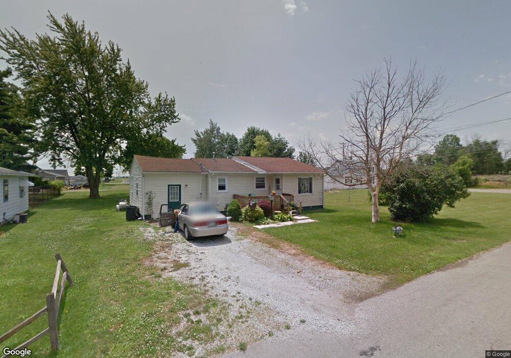
335 Gilbert St Kenton, OH 43326
Estimated Value: $104,000 - $131,000
3
Beds
1
Bath
1,224
Sq Ft
$96/Sq Ft
Est. Value
About This Home
This home is located at 335 Gilbert St, Kenton, OH 43326 and is currently estimated at $117,844, approximately $96 per square foot. 335 Gilbert St is a home located in Hardin County with nearby schools including Kenton Elementary School, Kenton Middle School, and Kenton High School.
Ownership History
Date
Name
Owned For
Owner Type
Purchase Details
Closed on
Aug 4, 2016
Sold by
Rarey Christa L and Manns Christa L
Bought by
Chatelain Rovestad Sally J and Chatelain Rovestad Costance P
Current Estimated Value
Purchase Details
Closed on
Jul 5, 2001
Bought by
Manns Christa L
Purchase Details
Closed on
Dec 16, 1999
Bought by
Patrick Lacy and Patrick Brenda L
Purchase Details
Closed on
Jun 13, 1994
Bought by
Cannode George A and Cannode Steph
Purchase Details
Closed on
Mar 31, 1988
Create a Home Valuation Report for This Property
The Home Valuation Report is an in-depth analysis detailing your home's value as well as a comparison with similar homes in the area
Home Values in the Area
Average Home Value in this Area
Purchase History
| Date | Buyer | Sale Price | Title Company |
|---|---|---|---|
| Chatelain Rovestad Sally J | $55,000 | None Available | |
| Manns Christa L | $50,000 | -- | |
| Patrick Lacy | $34,000 | -- | |
| Cannode George A | $32,000 | -- | |
| -- | $15,100 | -- |
Source: Public Records
Tax History Compared to Growth
Tax History
| Year | Tax Paid | Tax Assessment Tax Assessment Total Assessment is a certain percentage of the fair market value that is determined by local assessors to be the total taxable value of land and additions on the property. | Land | Improvement |
|---|---|---|---|---|
| 2024 | $1,189 | $26,700 | $2,930 | $23,770 |
| 2023 | $1,189 | $26,700 | $2,930 | $23,770 |
| 2022 | $1,141 | $24,010 | $2,040 | $21,970 |
| 2021 | $1,145 | $24,010 | $2,040 | $21,970 |
| 2020 | $1,031 | $24,010 | $2,040 | $21,970 |
| 2019 | $777 | $19,670 | $1,940 | $17,730 |
| 2018 | $778 | $19,670 | $1,940 | $17,730 |
| 2017 | $751 | $19,670 | $1,940 | $17,730 |
| 2016 | $697 | $18,710 | $2,130 | $16,580 |
| 2015 | $674 | $18,710 | $2,130 | $16,580 |
| 2014 | $793 | $18,710 | $2,130 | $16,580 |
| 2013 | $790 | $20,550 | $2,130 | $18,420 |
Source: Public Records
Map
Nearby Homes
- 320 Letson Ave
- 727 S Detroit St
- 639 S Main St
- 414 Robinson Ave
- 508 Decatur St
- 510 Decatur St
- 920 Cooper St
- 13450 State Route 292
- 121 S High St
- 530 E Franklin St
- 115 Scioto St
- 513 E Franklin St
- 39 Grape St
- 726 Tracy St
- 219 W Carrol St
- 79 Broadway St
- 509 E Carrol St
- 215 N Main St
- 702 W Franklin St Unit 702 1/2
- 233 N Main St