NOT LISTED FOR SALE

339 Castine Rd Castine, ME 04421

Estimated Value: $415,000 - $791,305

14 Acres
$40,630 Price per Acre
609,840 Sq Ft Lot

Last Sold July 06, 2021

Last sale price $630,000

Est. 10% decrease in value since last sale

Current estimated payment $3,371/month

294 Days on Market

Highlights

  • 800 Feet of Waterfront
  • Country Club
  • Farm
  • Public Beach
  • Property Near A Cove
  • Wooded Lot

About This Lot

As of July 2021

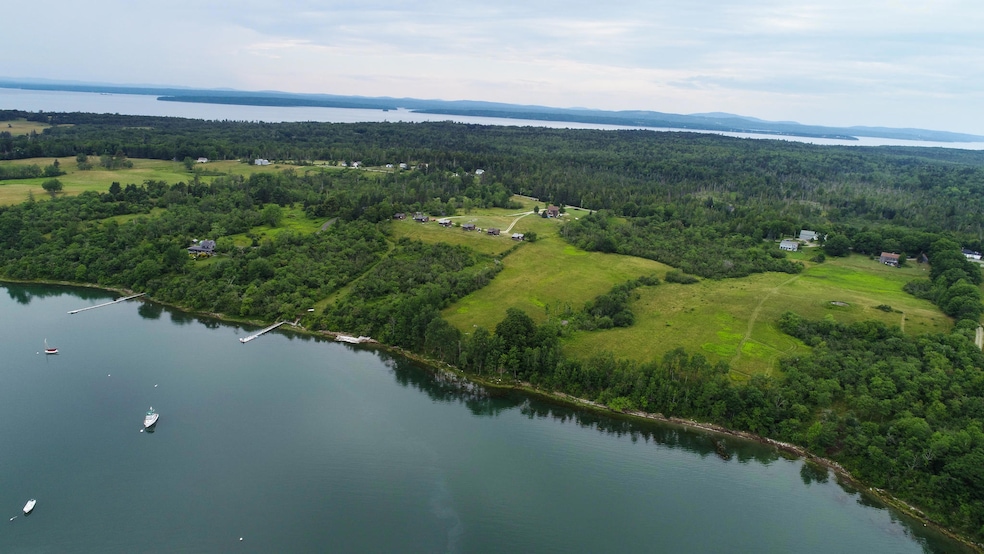
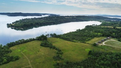
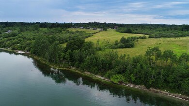
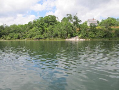
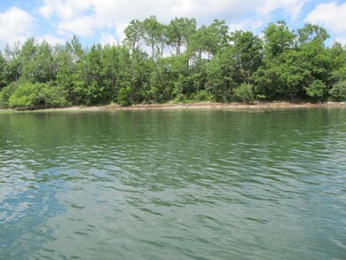
Great opportunity to own a large parcel of land in Castine. Lovely, east facing lot with 800+/- feet of deep water frontage on Hatch Cove including rolling fields and woods. Lots of possibilities with this parcel. If you are an avid sailor looking for a perfect, protected cove to moor your boat.......this is it!!! Plenty of 'water' for a dock and a deep water mooring.
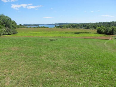
In addition, this lot offers acres of fields ideal for establishing a salt water farm. Why not join the growing community of organic farmer here on the Blue Hill Peninsula? There's plenty of room for multiple gardens, farm animals, barns and out buildings.
If sailing or farming isn't your 'thing'....but a simple, quiet life sitting on the front deck of your house, with a wonderful view of a tranquil bay is.....this might be a perfect spot for you.
This 14 acre parcel is sub-dividable.

Last Agent to Sell the Property

Susan MacNair

Saltmeadow Properties, Inc. Listed on: 07/13/2020

Last Buyer's Agent

John Bennett

The Swan Agency Sotheby's International Realty

Property Details

Property Type

  • Land

Est. Annual Taxes

  • $6,098

Lot Details

  • 14 Acre Lot
  • 800 Feet of Waterfront
  • Ocean Front
  • River Front
  • Public Beach
  • Rural Setting
  • Level Lot
  • Open Lot
  • Wooded Lot
  • Property is zoned shoreland

Parking

  • No Driveway

Farming

  • Farm
  • Agricultural
  • Pasture

Utilities

  • Electricity Not Available
  • Natural Gas Not Available
  • Water Not Available
  • Sewer Not Available

Additional Features

  • Water Views
  • Property is near a golf course

Listing and Financial Details

  • Tax Lot 21
  • Assessor Parcel Number CAST-000006-000000-000021

Community Details

Overview

  • No Home Owners Association

Recreation

  • Country Club
  • Property Near A Cove

Property Details

Property Type

Land

Est. Annual Taxes

$6,098

Lot Details

0

Listing Details

  • Prop. Type: Land
  • Lot Size Acres: 14.0
  • Road Surface Type: Paved
  • Water Body Name: Hatch Cove-Bagaduce River
  • MLS Status: Closed
  • Subdivision Name: no
  • Directions: From Bucksport come down Route 175 to Gary's Fuel. Stay straight on 166 and continue until the road splits (166 and 166A) Take the left fork and continue on about 2 miles. Property on the left. Look for signs.
  • Property Information:Lot Size Acres -: 14.0
  • Site:Level: Yes
  • Site:Open: Yes
  • Location:Near Golf Course: Yes
  • Water Info:Water Frontage2: Yes
  • Water Info:Water View2: Yes
  • Gas:No Gas: Yes
  • Location:Near Public Beach: Yes
  • Location:Rural: Yes
  • Water Info:Waterfront Amount -: 800.0
  • Water Info:Water Frontage Owned -: 800.0
  • Site:Wooded: Yes
  • Site:RollingSloping: Yes
  • Driveway:No Driveway: Yes
  • Property Information:Mobile Homes Allowed: Unknown
  • Location:Near Country Club: Yes
  • Electric:No Electric: Yes
  • Sewer:None4: Yes
  • Site:Agriculture: Yes
  • Site:Farm: Yes
  • Site:PastureField: Yes
  • Special Features: None
  • Property Sub Type: LotsLands

Exterior Features

  • Lot Features: Farm, Agriculture, Level, Open Lot, Rolling Slope, Wooded, Pasture, Near Golf Course, Near Public Beach, Near Shopping, Near Town, Rural
  • Waterfront Features: Cove, Ocean, River
  • Waterfront: Yes

Garage/Parking

  • Parking Features: No Driveway

Utilities

  • Electric: No Electric
  • Sewer: None
  • Water Source: None

Condo/Co-op/Association

  • Association: No

Lot Info

  • Lot Size Sq Ft: 609840.0
  • Parcel #: CAST-000006-000000-000021
  • Zoning: shoreland

Tax Info

  • Tax Annual Amount: 6098.0
  • Tax Book Number: 1874
  • Tax Lot: 21
  • Tax Map Number: 6
  • Tax Year: 2019

Range of Values:

Collateral Analytics

Collateral Analytics Collateral Analytics AVMs (Automated Valuation Model) employ a number of statistical approaches combined with neighborhood-specific comparable selection guarantees the most up-to-date and precise valuations.

Not Available

Collateral Analytics does not have data for the current month. Please view the chart for historical values.

ICE

ICE Mortgage Technology ICE Mortgage Technology’s AVM (Automated Valuation Model) is a state-of-the-art online residential property valuation tool that provides a quick and accurate estimate of the value of almost any home in the U.S.

Not Available

ICE Mortgage Technology does not have data for the current month. Please view the chart for historical values.

First American

First American First American Data & Analytics’ next-generation AVM combines unrivaled data assets with a blended ensemble of valuation models to produce highly accurate, reliable valuations you can trust.

Not Available

First American does not have data for the current month. Please view the chart for historical values.

Quantarium

Quantarium Quantarium’s valuation service, repeatedly proven the industry’s most accurate and comprehensive, is supercharged with a self-learning and auto-tuning AI engine that continually becomes smarter and more accurate as it processes daily inputs from the industry’s leading RE data lake.

Not Available

Quantarium does not have data for the current month. Please view the chart for historical values.

Average Value
Not Available
List Price
Sold Price
Create a Home Valuation Report for This Property
The Home Valuation Report is an in-depth analysis detailing your home's value as well as a comparison with similar homes in the area

Home Values in the Area

Source: Public Records

Average Home Value in this Area


Source: Public Records

Property History

Date Event Price Change Sq Ft Price
07/06/2021 07/06/21 Sold $630,000 -20.2% --
05/04/2021 05/04/21 Pending -- -- --
07/13/2020 07/13/20 For Sale $789,900 -- --
Source: Maine Listings

Tax History Compared to Growth

Source: Public Records

Tax History

Year Tax Paid Tax Assessment Tax Assessment Total Assessment is a certain percentage of the fair market value that is determined by local assessors to be the total taxable value of land and additions on the property. Land Improvement
2024 $2,284 $240,400 $114,700 $125,700
2023 $2,146 $181,900 $86,900 $95,000
2022 $2,029 $156,100 $74,600 $81,500
2021 $6,098 $534,900 $453,400 $81,500
2020 $6,098 $534,900 $453,400 $81,500
2019 $402 $534,900 $453,400 $81,500
2018 $6,285 $534,900 $453,400 $81,500
2017 $6,285 $534,900 $453,400 $81,500
2016 $6,010 $629,300 $533,400 $95,900
2015 $6,010 $629,300 $533,400 $95,900
2013 $5,852 $629,300 $533,400 $95,900
Source: Public Records

Agents Affiliated with this Home

  • Section Image
  • Section Image
See All Agents

Map

Source: Maine Listings

MLS Number: 1460182

Maine Listings

APN: CAST-000006-000000-000021