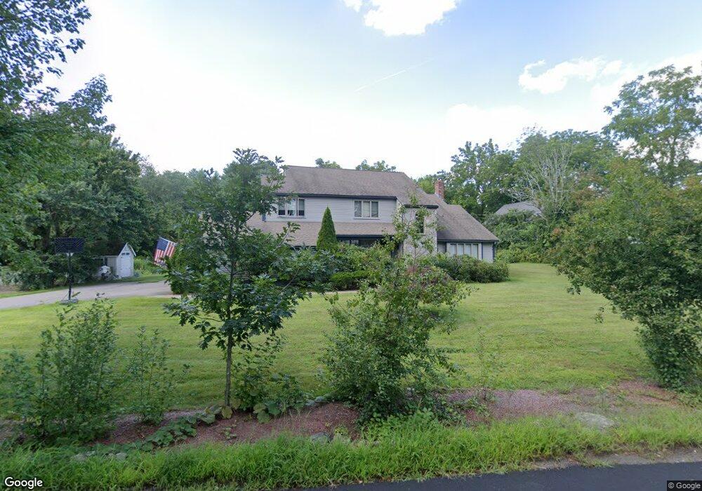
34 Cedar St Walpole, MA 02081
Estimated Value: $904,638 - $1,068,000
4
Beds
3
Baths
2,704
Sq Ft
$360/Sq Ft
Est. Value
About This Home
This home is located at 34 Cedar St, Walpole, MA 02081 and is currently estimated at $973,160, approximately $359 per square foot. 34 Cedar St is a home located in Norfolk County with nearby schools including Elm Street School, Eleanor N. Johnson Middle School, and Walpole High School.
Ownership History
Date
Name
Owned For
Owner Type
Purchase Details
Closed on
Oct 25, 2010
Sold by
Collins Michael J
Bought by
Collins Michael J and Collins Yuliya
Current Estimated Value
Home Financials for this Owner
Home Financials are based on the most recent Mortgage that was taken out on this home.
Original Mortgage
$48,400
Outstanding Balance
$31,982
Interest Rate
4.3%
Estimated Equity
$941,178
Purchase Details
Closed on
Jun 24, 1998
Sold by
Ward John D and Ward Debra J
Bought by
Collins Michael J
Purchase Details
Closed on
Oct 25, 1991
Sold by
Hodgdon Royal G and Hodgdon Gloria
Bought by
Ward John D and Ward Debra J
Purchase Details
Closed on
Jul 28, 1989
Sold by
Pinecrest Rt
Bought by
Hodgon Royal G
Create a Home Valuation Report for This Property
The Home Valuation Report is an in-depth analysis detailing your home's value as well as a comparison with similar homes in the area
Home Values in the Area
Average Home Value in this Area
Purchase History
| Date | Buyer | Sale Price | Title Company |
|---|---|---|---|
| Collins Michael J | -- | -- | |
| Collins Michael J | $272,000 | -- | |
| Ward John D | $188,000 | -- | |
| Hodgon Royal G | $225,000 | -- |
Source: Public Records
Mortgage History
| Date | Status | Borrower | Loan Amount |
|---|---|---|---|
| Open | Hodgon Royal G | $48,400 | |
| Previous Owner | Hodgon Royal G | $340,000 |
Source: Public Records
Tax History
| Year | Tax Paid | Tax Assessment Tax Assessment Total Assessment is a certain percentage of the fair market value that is determined by local assessors to be the total taxable value of land and additions on the property. | Land | Improvement |
|---|---|---|---|---|
| 2025 | $10,909 | $850,300 | $332,000 | $518,300 |
| 2024 | $10,576 | $800,000 | $319,200 | $480,800 |
| 2023 | $10,087 | $726,200 | $277,600 | $448,600 |
| 2022 | $9,428 | $652,000 | $257,000 | $395,000 |
| 2021 | $9,058 | $610,400 | $242,500 | $367,900 |
| 2020 | $8,661 | $577,800 | $228,600 | $349,200 |
| 2019 | $8,433 | $558,500 | $219,700 | $338,800 |
| 2018 | $8,399 | $550,000 | $211,700 | $338,300 |
| 2017 | $8,119 | $529,600 | $203,500 | $326,100 |
| 2016 | $7,915 | $508,700 | $197,600 | $311,100 |
| 2015 | $7,615 | $485,000 | $188,300 | $296,700 |
| 2014 | $7,250 | $460,000 | $188,300 | $271,700 |
Source: Public Records
Map
Nearby Homes
- 375 Winter St
- 4 Haydn Ln
- 16R Eldor Dr
- 5 Jackson Dr
- 1187 West St
- 260 Summer St
- 9 Pearl St
- 3 Weathervane Dr Unit 1
- 10 Weathervane Dr Unit 20
- 465 Lincoln Rd
- 38 Irving Dr
- 533 Lincoln Rd
- 3 Stone Hill Terrace
- 1549 Washington St Unit A
- 7 Hill St Unit 12
- 7 Hill St Unit 16
- 25 Sandtrap Cir Unit 8
- 29 Sandtrap Cir Unit 6
- 27 Sandtrap Cir Unit 7
- 21 Sandtrap Cir Unit 10
Your Personal Tour Guide
Ask me questions while you tour the home.