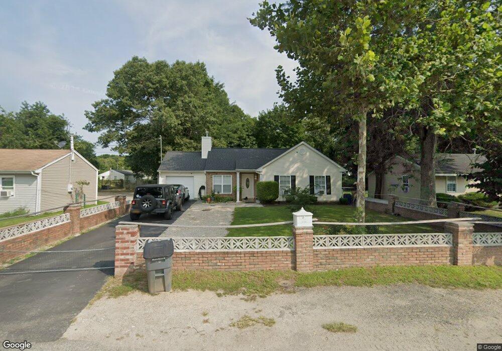
34 Phillips St Riverhead, NY 11901
Estimated Value: $463,000 - $535,000
3
Beds
1
Bath
990
Sq Ft
$513/Sq Ft
Est. Value
About This Home
This home is located at 34 Phillips St, Riverhead, NY 11901 and is currently estimated at $507,594, approximately $512 per square foot. 34 Phillips St is a home located in Suffolk County with nearby schools including Pulaski Street Intermediate School, Riverhead Middle School, and Riverhead Senior High School.
Ownership History
Date
Name
Owned For
Owner Type
Purchase Details
Closed on
Oct 9, 2020
Sold by
Lewis Delores
Bought by
Lehmann Nathan and Lehmann Jessica
Current Estimated Value
Home Financials for this Owner
Home Financials are based on the most recent Mortgage that was taken out on this home.
Original Mortgage
$318,573
Outstanding Balance
$282,837
Interest Rate
2.8%
Mortgage Type
New Conventional
Estimated Equity
$224,757
Purchase Details
Closed on
Jan 6, 2005
Sold by
Long Island Partnership Community Development
Bought by
Lewis Delores
Purchase Details
Closed on
Apr 27, 2001
Sold by
The Town Of Riverhead
Bought by
The Long Island Prtnrshp Community Devt
Purchase Details
Closed on
Jun 4, 1998
Sold by
Rambo Robert C
Bought by
Town Of Riverhead
Create a Home Valuation Report for This Property
The Home Valuation Report is an in-depth analysis detailing your home's value as well as a comparison with similar homes in the area
Home Values in the Area
Average Home Value in this Area
Purchase History
| Date | Buyer | Sale Price | Title Company |
|---|---|---|---|
| Lehmann Nathan | $324,500 | None Available | |
| Lewis Delores | $137,713 | Stephen Kuzma | |
| The Long Island Prtnrshp Community Devt | $10,000 | Safe Harbor Title Agency | |
| Town Of Riverhead | $25,000 | Chicago Title Insurance Co |
Source: Public Records
Mortgage History
| Date | Status | Borrower | Loan Amount |
|---|---|---|---|
| Open | Lehmann Nathan | $318,573 |
Source: Public Records
Tax History
| Year | Tax Paid | Tax Assessment Tax Assessment Total Assessment is a certain percentage of the fair market value that is determined by local assessors to be the total taxable value of land and additions on the property. | Land | Improvement |
|---|---|---|---|---|
| 2024 | $6,012 | $26,500 | $6,200 | $20,300 |
| 2023 | $6,012 | $26,500 | $6,200 | $20,300 |
| 2022 | $4,862 | $26,500 | $6,200 | $20,300 |
| 2021 | $4,862 | $26,500 | $6,200 | $20,300 |
| 2020 | $4,480 | $26,500 | $6,200 | $20,300 |
| 2019 | $4,480 | $26,500 | $6,200 | $20,300 |
| 2018 | -- | $26,500 | $6,200 | $20,300 |
| 2017 | $4,300 | $26,500 | $6,200 | $20,300 |
| 2016 | $4,142 | $26,500 | $6,200 | $20,300 |
| 2015 | -- | $26,500 | $6,200 | $20,300 |
| 2014 | -- | $26,500 | $6,200 | $20,300 |
Source: Public Records
Map
Nearby Homes
- 49 Sunrise Ave
- 30 Fairway Ave
- 61 Fairway Ave
- 18 Tyte Dr
- 50 Strawberry Commons
- 70 Strawberry Commons
- 37 Hubbard Ave
- 37 Hubbard Ave Unit 38
- 37 Hubbard Ave Unit 95
- 923 E Main St
- 519 Old Country Rd Unit 519
- 94 Kings Dr
- 630 Northville Turnpike
- 761 E Main St
- 28 & 34 Townsend Ave
- 25/58 NYS (52 Main Rd) Route
- 309 Fanning Blvd
- 133 Trout Brook Ln
- 911 Ostrander Ave
- 117 Trout Brook Ln
Your Personal Tour Guide
Ask me questions while you tour the home.