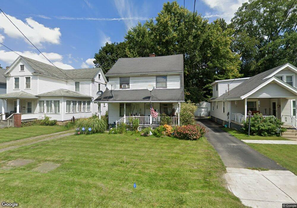
3411 Powers Way Youngstown, OH 44502
Buckeye Plat NeighborhoodEstimated Value: $62,563 - $77,000
3
Beds
2
Baths
1,370
Sq Ft
$50/Sq Ft
Est. Value
About This Home
This home is located at 3411 Powers Way, Youngstown, OH 44502 and is currently estimated at $68,891, approximately $50 per square foot. 3411 Powers Way is a home located in Mahoning County with nearby schools including Paul C. Bunn Elementary School, Chaney High School, and Summit Academy Secondary School - Youngstown.
Ownership History
Date
Name
Owned For
Owner Type
Purchase Details
Closed on
Jan 30, 2010
Sold by
Hasein A Michael and Hasein Ashraph Michael
Bought by
Saylor Nancy
Current Estimated Value
Purchase Details
Closed on
Sep 13, 2007
Sold by
Perry Kathleen A and Swartzfager Kathleen A
Bought by
Deers Homes Llc
Purchase Details
Closed on
Apr 16, 2003
Sold by
Swartzfager Kathleen Ann
Bought by
Swartzfager Leonard A
Purchase Details
Closed on
Apr 8, 1977
Bought by
Swartzfoger Leonard A and Swartzfoger K
Create a Home Valuation Report for This Property
The Home Valuation Report is an in-depth analysis detailing your home's value as well as a comparison with similar homes in the area
Home Values in the Area
Average Home Value in this Area
Purchase History
| Date | Buyer | Sale Price | Title Company |
|---|---|---|---|
| Saylor Nancy | $8,400 | None Available | |
| Deers Homes Llc | $35,000 | None Available | |
| Swartzfager Leonard A | -- | -- | |
| Swartzfoger Leonard A | -- | -- |
Source: Public Records
Tax History Compared to Growth
Tax History
| Year | Tax Paid | Tax Assessment Tax Assessment Total Assessment is a certain percentage of the fair market value that is determined by local assessors to be the total taxable value of land and additions on the property. | Land | Improvement |
|---|---|---|---|---|
| 2024 | $376 | $7,640 | $960 | $6,680 |
| 2023 | $373 | $7,640 | $960 | $6,680 |
| 2022 | $362 | $5,440 | $960 | $4,480 |
| 2021 | $345 | $5,440 | $960 | $4,480 |
| 2020 | $347 | $5,440 | $960 | $4,480 |
| 2019 | $354 | $4,950 | $880 | $4,070 |
| 2018 | $413 | $4,950 | $880 | $4,070 |
| 2017 | $355 | $4,950 | $880 | $4,070 |
| 2016 | $348 | $5,230 | $880 | $4,350 |
| 2015 | $341 | $5,230 | $880 | $4,350 |
| 2014 | -- | $5,230 | $880 | $4,350 |
| 2013 | $334 | $5,230 | $880 | $4,350 |
Source: Public Records
Map
Nearby Homes
- 3337 Powers Way
- 3448 Neilson Ave
- 3509 Lenox Ave
- 3222 Sheridan Rd
- 2016 Pointview Ave
- 2007 E Midlothian Blvd
- 1954 Everett Ave
- 0 Crescent Dr Unit 5124984
- 2510 E Midlothian Blvd
- 3551 Shirley Rd
- 0 Weston Ave
- 2562 Mount Vernon Ave
- 1313 Humbolt Ave
- 1928 Medford Ave
- 2577 E Midlothian Blvd
- 2001 Brownlee Ave
- 2743 Mount Vernon Ave
- 1653 Brownlee Ave
- 0 Tampa Ave Unit 4420178
- 1654 Wakefield Ave
- 3409 Powers Way
- 3417 Powers Way
- 3421 Powers Way
- 3407 Powers Way
- 3423 Powers Way
- 3410 Powers Way
- 3431 Powers Way
- 3408 Belden Ave
- 3412 Belden Ave
- 3416 Belden Ave
- 3333 Powers Way
- 3424 Powers Way
- 3404 Powers Way
- 3408 Powers Way
- 3336 Belden Ave
- 3412 Powers Way
- 3329 Powers Way
- 3440 Belden Ave
- 3435 Powers Way
- 3428 Powers Way