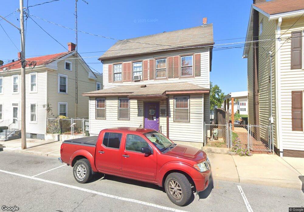
343 N Cannon Ave Hagerstown, MD 21740
Central NeighborhoodEstimated Value: $163,668 - $234,000
--
Bed
1
Bath
1,276
Sq Ft
$155/Sq Ft
Est. Value
About This Home
This home is located at 343 N Cannon Ave, Hagerstown, MD 21740 and is currently estimated at $197,167, approximately $154 per square foot. 343 N Cannon Ave is a home located in Washington County with nearby schools including Pangborn Elementary School, Otsego West Campus High School, and Northern Middle School.
Ownership History
Date
Name
Owned For
Owner Type
Purchase Details
Closed on
Jul 13, 1992
Sold by
Sharer Randy K
Bought by
Sharer Randy K
Current Estimated Value
Home Financials for this Owner
Home Financials are based on the most recent Mortgage that was taken out on this home.
Original Mortgage
$37,500
Interest Rate
8.13%
Create a Home Valuation Report for This Property
The Home Valuation Report is an in-depth analysis detailing your home's value as well as a comparison with similar homes in the area
Home Values in the Area
Average Home Value in this Area
Purchase History
| Date | Buyer | Sale Price | Title Company |
|---|---|---|---|
| Sharer Randy K | $5,000 | -- |
Source: Public Records
Mortgage History
| Date | Status | Borrower | Loan Amount |
|---|---|---|---|
| Closed | Sharer Randy K | $37,500 |
Source: Public Records
Tax History Compared to Growth
Tax History
| Year | Tax Paid | Tax Assessment Tax Assessment Total Assessment is a certain percentage of the fair market value that is determined by local assessors to be the total taxable value of land and additions on the property. | Land | Improvement |
|---|---|---|---|---|
| 2025 | $1,205 | $148,700 | $30,300 | $118,400 |
| 2024 | $1,205 | $132,300 | $0 | $0 |
| 2023 | $1,060 | $115,900 | $0 | $0 |
| 2022 | $906 | $99,500 | $30,300 | $69,200 |
| 2021 | $852 | $95,500 | $0 | $0 |
| 2020 | $852 | $91,500 | $0 | $0 |
| 2019 | $818 | $87,500 | $30,300 | $57,200 |
| 2018 | $818 | $87,500 | $30,300 | $57,200 |
| 2017 | $818 | $87,500 | $0 | $0 |
| 2016 | -- | $94,600 | $0 | $0 |
| 2015 | -- | $94,600 | $0 | $0 |
| 2014 | $1,513 | $94,600 | $0 | $0 |
Source: Public Records
Map
Nearby Homes
- 133 Randolph Ave
- 409 411 N Mulberry St
- 409 N Mulberry St
- 207 N Mulberry St
- 338 Liberty St
- 142 East Ave
- 136 N Cannon Ave
- 308 N Locust St
- 351 Liberty St
- 133 Broadway
- 243 N Locust St
- 440 Liberty St
- 115 East Ave
- 227 N Locust St
- 312 E Franklin St
- 414 E Franklin St
- 54 Randolph Ave
- 200 E Franklin St
- 351 Vale St
- 528 Jefferson St
- 347 N Cannon Ave
- 339 N Cannon Ave
- 349 N Cannon Ave
- 351 N Cannon Ave
- 331 N Cannon Ave
- 353 N Cannon Ave
- 329 N Cannon Ave
- 327 N Cannon Ave
- 322 N Mulberry St
- 318 N Mulberry St
- 324 N Mulberry St
- 326 N Mulberry St
- 342 N Cannon Ave
- 314 N Mulberry St
- 314 N Mulberry St
- 314 N Mulberry St
- 328 N Mulberry St
- 338 N Cannon Ave
- 344 N Cannon Ave
- 325 N Cannon Ave