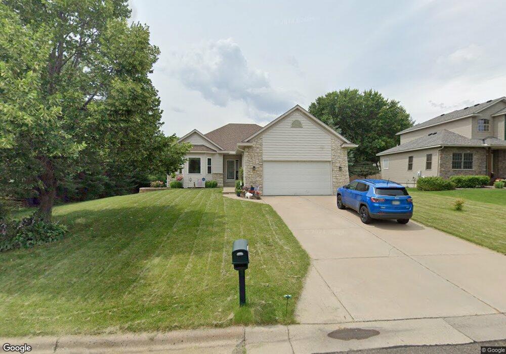
3435 Michael Ave Saint Paul, MN 55110
Estimated Value: $409,000 - $468,000
2
Beds
2
Baths
1,856
Sq Ft
$239/Sq Ft
Est. Value
About This Home
This home is located at 3435 Michael Ave, Saint Paul, MN 55110 and is currently estimated at $444,320, approximately $239 per square foot. 3435 Michael Ave is a home located in Ramsey County with nearby schools including Willow Lane Elementary School, Sunrise Park Middle School, and Gentry Academy High.
Ownership History
Date
Name
Owned For
Owner Type
Purchase Details
Closed on
Nov 10, 2009
Sold by
Federal Home Loan Mortgage Corporation
Bought by
Mccluskey Stoll Investments Llc
Current Estimated Value
Purchase Details
Closed on
Jan 16, 2003
Sold by
Southwind Builders Inc
Bought by
Mccluskey Joan Kathleen
Purchase Details
Closed on
Aug 1, 2002
Sold by
Rollinger Gregory A and Rollinger Dee Ann
Bought by
Southwind Holdings Llc
Create a Home Valuation Report for This Property
The Home Valuation Report is an in-depth analysis detailing your home's value as well as a comparison with similar homes in the area
Home Values in the Area
Average Home Value in this Area
Purchase History
| Date | Buyer | Sale Price | Title Company |
|---|---|---|---|
| Mccluskey Stoll Investments Llc | $159,900 | -- | |
| Mccluskey Joan Kathleen | $349,158 | -- | |
| Southwind Holdings Llc | $210,000 | -- |
Source: Public Records
Tax History Compared to Growth
Tax History
| Year | Tax Paid | Tax Assessment Tax Assessment Total Assessment is a certain percentage of the fair market value that is determined by local assessors to be the total taxable value of land and additions on the property. | Land | Improvement |
|---|---|---|---|---|
| 2025 | $5,022 | $418,600 | $103,600 | $315,000 |
| 2023 | $5,022 | $379,800 | $103,600 | $276,200 |
| 2022 | $3,868 | $357,300 | $103,600 | $253,700 |
| 2021 | $3,582 | $294,700 | $103,600 | $191,100 |
| 2020 | $3,574 | $281,200 | $103,600 | $177,600 |
| 2019 | $2,844 | $263,600 | $103,600 | $160,000 |
| 2018 | $2,716 | $228,800 | $103,600 | $125,200 |
| 2017 | $2,470 | $224,400 | $103,600 | $120,800 |
| 2016 | $2,578 | $0 | $0 | $0 |
| 2015 | $2,492 | $200,800 | $97,300 | $103,500 |
| 2014 | $3,274 | $0 | $0 | $0 |
Source: Public Records
Map
Nearby Homes
- 3580 Rooney Place
- 3561 Rooney Place
- 3571 Rooney Place
- 3237 Jerry Ct
- 1836 Belland Ave
- 1827 County Road E E Unit 18
- 3620 Highland Ave
- 3644 Linden Ave Unit 11
- 3458 Savannah Ave
- 3734 Little Linden Curve Unit 114
- 1778 Linden Cove
- 1792 Cheri Ct
- 1794 Cheri Ct
- 1795 Cheri Ct
- 2086 Dorothy Ave
- 2075 Dorothy Ave
- 3760 White Bear Ave N
- 3823 Linden Ave
- 1613 County Road D E Unit L
- 3750 Van Dyke St
- 3425 Michael Ave
- 3445 Michael Ave
- 3430 Auger Ave
- 3440 Auger Ave
- 3415 Michael Ave
- 3396 Auger Ave
- 3440 Michael Ave
- 3430 Michael Ave
- 3450 Auger Ave
- 3450 Michael Ave
- 3390 Auger Ave
- 3420 Michael Ave
- 3405 Michael Ave
- 3460 Auger Ave
- 1855 Kathy Ln
- 1880 Kathy Ln
- 3384 Auger Ave
- 1865 Kathy Ln
- 1875 Ivy Ln
- 3425 Auger Ave