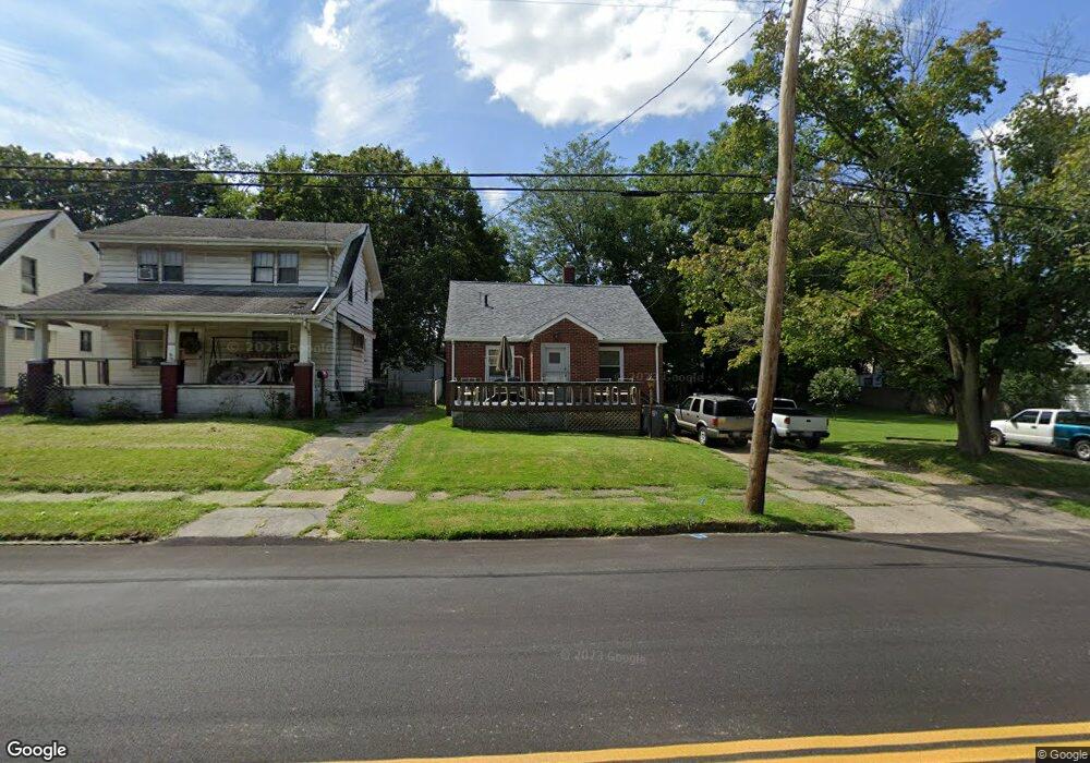
3436 Powers Way Youngstown, OH 44502
Buckeye Plat NeighborhoodEstimated Value: $67,000 - $84,000
2
Beds
2
Baths
928
Sq Ft
$80/Sq Ft
Est. Value
About This Home
This home is located at 3436 Powers Way, Youngstown, OH 44502 and is currently estimated at $74,688, approximately $80 per square foot. 3436 Powers Way is a home located in Mahoning County with nearby schools including Paul C. Bunn Elementary School, Chaney High School, and Summit Academy Secondary School - Youngstown.
Ownership History
Date
Name
Owned For
Owner Type
Purchase Details
Closed on
Jun 27, 2017
Sold by
Mahining County Land Reutilization Corpo and Yemma Daniel R
Bought by
Maessner Lawrence Lee and Maessner Cynthia Elaine
Current Estimated Value
Purchase Details
Closed on
Sep 8, 2004
Sold by
Alnizami Hanan Abdel Karim
Bought by
Maessner Lawrence L and Maessner Cynthia E
Home Financials for this Owner
Home Financials are based on the most recent Mortgage that was taken out on this home.
Original Mortgage
$36,000
Interest Rate
8.85%
Mortgage Type
Purchase Money Mortgage
Purchase Details
Closed on
Jul 15, 2002
Sold by
Azmi Altawil
Bought by
Abdel Hanan and Alnizami Karim
Purchase Details
Closed on
Nov 18, 1999
Sold by
Gonda Sylvester J and Gonda Marie
Bought by
Altawil Azmi
Purchase Details
Closed on
May 20, 1985
Bought by
Gonda Sylvester J
Create a Home Valuation Report for This Property
The Home Valuation Report is an in-depth analysis detailing your home's value as well as a comparison with similar homes in the area
Home Values in the Area
Average Home Value in this Area
Purchase History
| Date | Buyer | Sale Price | Title Company |
|---|---|---|---|
| Maessner Lawrence Lee | -- | None Available | |
| Maessner Lawrence L | $40,000 | -- | |
| Abdel Hanan | -- | -- | |
| Altawil Azmi | $10,000 | -- | |
| Gonda Sylvester J | $21,000 | -- |
Source: Public Records
Mortgage History
| Date | Status | Borrower | Loan Amount |
|---|---|---|---|
| Previous Owner | Maessner Lawrence L | $36,000 | |
| Closed | Maessner Lawrence L | $4,000 |
Source: Public Records
Tax History Compared to Growth
Tax History
| Year | Tax Paid | Tax Assessment Tax Assessment Total Assessment is a certain percentage of the fair market value that is determined by local assessors to be the total taxable value of land and additions on the property. | Land | Improvement |
|---|---|---|---|---|
| 2024 | $579 | $12,130 | $830 | $11,300 |
| 2023 | $575 | $12,130 | $830 | $11,300 |
| 2022 | $633 | $10,290 | $830 | $9,460 |
| 2021 | $633 | $10,290 | $830 | $9,460 |
| 2020 | $637 | $10,290 | $830 | $9,460 |
| 2019 | $647 | $9,360 | $760 | $8,600 |
| 2018 | $654 | $9,360 | $760 | $8,600 |
| 2017 | $651 | $9,360 | $760 | $8,600 |
| 2016 | $641 | $9,920 | $760 | $9,160 |
| 2015 | $627 | $9,920 | $760 | $9,160 |
| 2014 | $623 | $9,920 | $760 | $9,160 |
| 2013 | $614 | $9,920 | $760 | $9,160 |
Source: Public Records
Map
Nearby Homes
- 3448 Neilson Ave
- 3337 Powers Way
- 3509 Lenox Ave
- 2016 Pointview Ave
- 3222 Sheridan Rd
- 2007 E Midlothian Blvd
- 1954 Everett Ave
- 0 Crescent Dr Unit 5124984
- 1447 Humbolt Ave
- 0 Weston Ave
- 2510 E Midlothian Blvd
- 3551 Shirley Rd
- 1928 Medford Ave
- 2562 Mount Vernon Ave
- 1313 Humbolt Ave
- 2577 E Midlothian Blvd
- 2001 Brownlee Ave
- 1653 Brownlee Ave
- 2743 Mount Vernon Ave
- 1654 Wakefield Ave
- 3446 Powers Way
- 3434 Powers Way
- 3448 Powers Way
- 3452 Powers Way
- 3428 Powers Way
- 3439 Neilson Ave
- 3435 Powers Way
- 3431 Neilson Ave
- 3443 Neilson Ave
- 3458 Powers Way
- 3424 Powers Way
- 3451 Neilson Ave
- 3423 Powers Way
- 3412 Powers Way
- 3460 Powers Way
- 3423 Neilson Ave
- 3431 Powers Way
- 3455 Neilson Ave
- 3410 Powers Way
- 3419 Neilson Ave