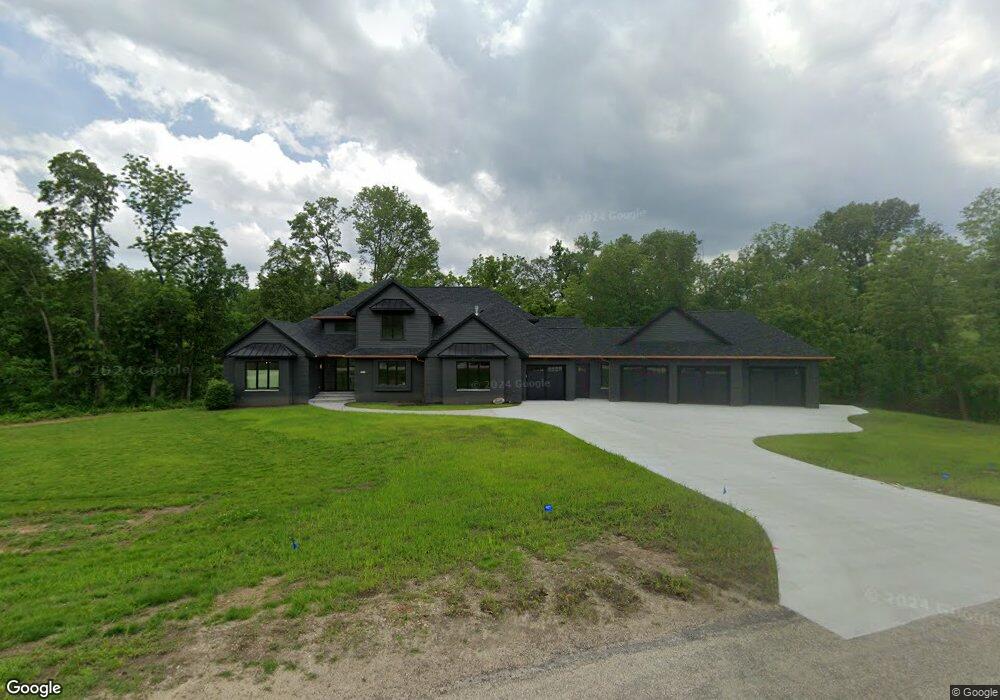
345 Innes Way Cedar Rapids, IA 52403
Estimated Value: $487,000
4
Beds
5
Baths
3,214
Sq Ft
$152/Sq Ft
Est. Value
About This Home
This home is located at 345 Innes Way, Cedar Rapids, IA 52403 and is currently priced at $487,000, approximately $151 per square foot. 345 Innes Way is a home located in Linn County with nearby schools including Wilkins Elementary School, Excelsior Middle School, and Linn-Mar High School.
Ownership History
Date
Name
Owned For
Owner Type
Purchase Details
Closed on
Jul 19, 2021
Sold by
Sharp Patricia C
Bought by
Cassill Landon and Cassill Kaitlan
Current Estimated Value
Home Financials for this Owner
Home Financials are based on the most recent Mortgage that was taken out on this home.
Original Mortgage
$450,000
Outstanding Balance
$343,922
Interest Rate
2.9%
Mortgage Type
Future Advance Clause Open End Mortgage
Purchase Details
Closed on
Mar 3, 2000
Sold by
Stairs Keith
Bought by
Brislawn Lisa and Stairs Lisa
Home Financials for this Owner
Home Financials are based on the most recent Mortgage that was taken out on this home.
Original Mortgage
$44,250
Interest Rate
10.2%
Create a Home Valuation Report for This Property
The Home Valuation Report is an in-depth analysis detailing your home's value as well as a comparison with similar homes in the area
Home Values in the Area
Average Home Value in this Area
Purchase History
| Date | Buyer | Sale Price | Title Company |
|---|---|---|---|
| Cassill Landon | $649,000 | None Available | |
| Brislawn Lisa | -- | -- |
Source: Public Records
Mortgage History
| Date | Status | Borrower | Loan Amount |
|---|---|---|---|
| Open | Cassill Landon | $450,000 | |
| Previous Owner | Brislawn Lisa | $44,250 |
Source: Public Records
Tax History Compared to Growth
Tax History
| Year | Tax Paid | Tax Assessment Tax Assessment Total Assessment is a certain percentage of the fair market value that is determined by local assessors to be the total taxable value of land and additions on the property. | Land | Improvement |
|---|---|---|---|---|
| 2022 | $7,436 | $509,500 | $120,200 | $389,300 |
| 2021 | $8,458 | $509,500 | $120,200 | $389,300 |
| 2020 | $8,458 | $527,500 | $100,000 | $427,500 |
| 2019 | $7,906 | $494,400 | $100,000 | $394,400 |
| 2018 | $7,552 | $494,400 | $100,000 | $394,400 |
| 2017 | $7,748 | $490,700 | $120,200 | $370,500 |
| 2016 | $7,689 | $490,700 | $120,200 | $370,500 |
| 2015 | $7,747 | $490,700 | $120,200 | $370,500 |
| 2014 | $7,610 | $490,700 | $120,200 | $370,500 |
| 2013 | $7,308 | $490,700 | $120,200 | $370,500 |
Source: Public Records
Map
Nearby Homes
- 6201 Lakeside Rd
- 5638 Meadow Grass Cir SE
- 5750 Meadow Grass Cir SE
- 5658 Meadow Grass Cir SE
- 819 Tumble Grass Ct SE
- 827 Tumble Grass Ct SE
- 2215 Timber Wolf Trail SE
- 921 Rosedale Rd SE
- 4809 Mcgowan Dr
- 1209 Rose St
- 1223 Vernon Hill Blvd
- 6936 Hackberry Loop
- 6932 Hackberry Loop
- 6849 Pumpkin Patch Blvd
- 6485 Cabbage Patch Place
- 6876 Bottom Land Ln
- 6859 Pumpkin Patch Blvd
- 6934 Hackberry Loop
- 5029 Broadlawn Dr SE
- 0 S Lot 9 Parkridge Rd
- 365 Abbotsford Rd
- 358 Abbotsford Rd
- 310 Abbotsford Rd
- 383 Abbotsford Rd
- 325 Innes Way
- 6630 Country Creek Ln
- Lot 1 Country Creek Ln
- 276 Abbotsford Rd
- 293 Haggis Way
- 449 Dows Rd
- 330 Rosedale Rd
- 6445 Country Creek Ln
- 1 Deerfield Ln
- 300 Rosedale Rd
- 275 Haggis Way
- 6835 Lakeside Rd
- 353 Squaw Ridge Rd
- 258 Abbotsford Rd
- 464 Dows Rd
- 2 Deerfield Ln