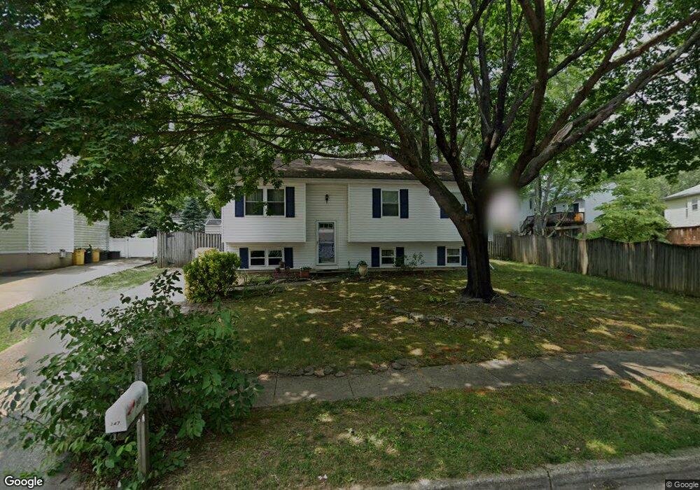
347 Ternwing Ct Arnold, MD 21012
Estimated Value: $427,304 - $550,000
Studio
2
Baths
1,270
Sq Ft
$391/Sq Ft
Est. Value
About This Home
This home is located at 347 Ternwing Ct, Arnold, MD 21012 and is currently estimated at $496,826, approximately $391 per square foot. 347 Ternwing Ct is a home located in Anne Arundel County with nearby schools including Broadneck Elementary School, Magothy River Middle School, and Broadneck High School.
Ownership History
Date
Name
Owned For
Owner Type
Purchase Details
Closed on
Oct 20, 2025
Sold by
Bellistri Joyce Anne and Chesson Joyce A
Bought by
Joyce Anne Bellistri Revocable Trust and Bellistri
Current Estimated Value
Purchase Details
Closed on
Aug 1, 2002
Sold by
Chesson Wayne A
Bought by
Chesson Joyce A
Purchase Details
Closed on
Dec 27, 1988
Sold by
Whitney Claire H
Bought by
Chesson Wayne A
Home Financials for this Owner
Home Financials are based on the most recent Mortgage that was taken out on this home.
Original Mortgage
$95,150
Interest Rate
10.68%
Create a Home Valuation Report for This Property
The Home Valuation Report is an in-depth analysis detailing your home's value as well as a comparison with similar homes in the area
Home Values in the Area
Average Home Value in this Area
Purchase History
| Date | Buyer | Sale Price | Title Company |
|---|---|---|---|
| Joyce Anne Bellistri Revocable Trust | -- | None Listed On Document | |
| Chesson Joyce A | -- | -- | |
| Chesson Wayne A | $119,000 | -- |
Source: Public Records
Mortgage History
| Date | Status | Borrower | Loan Amount |
|---|---|---|---|
| Previous Owner | Chesson Wayne A | $95,150 |
Source: Public Records
Tax History
| Year | Tax Paid | Tax Assessment Tax Assessment Total Assessment is a certain percentage of the fair market value that is determined by local assessors to be the total taxable value of land and additions on the property. | Land | Improvement |
|---|---|---|---|---|
| 2025 | $3,275 | $390,667 | -- | -- |
| 2024 | $3,275 | $364,800 | $230,000 | $134,800 |
| 2023 | $3,188 | $360,267 | $0 | $0 |
| 2022 | $2,986 | $355,733 | $0 | $0 |
| 2020 | $2,845 | $341,367 | $0 | $0 |
| 2019 | $2,796 | $331,533 | $0 | $0 |
| 2018 | $3,262 | $321,700 | $172,500 | $149,200 |
| 2017 | $2,638 | $317,867 | $0 | $0 |
| 2016 | -- | $314,033 | $0 | $0 |
| 2015 | -- | $310,200 | $0 | $0 |
| 2014 | -- | $299,400 | $0 | $0 |
Source: Public Records
Map
Nearby Homes
- 308 Clifton Ave
- 876 Nancy Lynn Ln
- 930 Whitstable Blvd
- 303 Ternwing Dr
- 319 Alameda Pkwy
- 1176 White Coral Ct
- 342 Buena Vista Ave
- 554 Melissa Ct
- 1233 Birchcrest Ct
- 1078 Brightleaf Ct
- 312 Rosslare Dr
- 434 College Pkwy
- 805 Barrett Ave
- 404 Alameda Pkwy
- 394 Kings College Dr
- 508 Bay Hills Dr
- 856 Imperial Rd
- 413 Ridgeview Ct
- 889 Lynch Dr
- 854 Imperial Rd
- 349 Ternwing Ct
- 345 Ternwing Dr
- 343 Ternwing Dr
- 339 Ternwing Dr
- 351 Ternwing Ct
- 341 Ternwing Dr
- 353 Ternwing Ct
- 365 Ternwing Dr
- 363 Ternwing Ct
- 337 Ternwing Dr
- 355 Ternwing Ct
- 361 Ternwing Ct
- 367 Ternwing Dr
- 335 Ternwing Dr
- 357 Ternwing Ct
- 359 Ternwing Ct
- 346 Ternwing Dr
- 344 Ternwing Dr
- 348 Ternwing Dr
- 342 Ternwing Dr
Your Personal Tour Guide
Ask me questions while you tour the home.