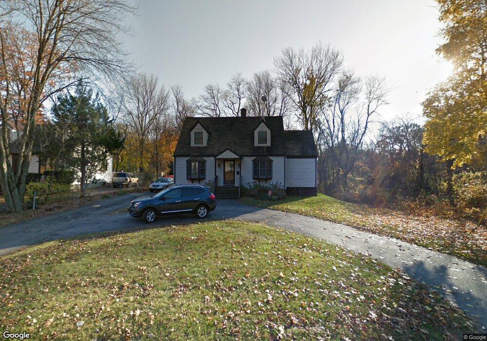
348 Broadbridge Rd Bridgeport, CT 06610
North Bridgeport NeighborhoodEstimated Value: $374,000 - $418,000
3
Beds
2
Baths
1,520
Sq Ft
$264/Sq Ft
Est. Value
About This Home
This home is located at 348 Broadbridge Rd, Bridgeport, CT 06610 and is currently estimated at $400,977, approximately $263 per square foot. 348 Broadbridge Rd is a home located in Fairfield County with nearby schools including Hooker School and Harding High School.
Ownership History
Date
Name
Owned For
Owner Type
Purchase Details
Closed on
Aug 25, 2005
Sold by
Morelli Vincent
Bought by
Fields Marc and Andrews Verlinda
Current Estimated Value
Purchase Details
Closed on
May 17, 2001
Sold by
Lecza Jeffrey P and Lecze Gianna
Bought by
Morelli Vincent G and Morelli Kristen L
Purchase Details
Closed on
Jan 30, 1996
Sold by
Newell Beverly C
Bought by
Lecza Jeffrey P and Lecza Gianna
Create a Home Valuation Report for This Property
The Home Valuation Report is an in-depth analysis detailing your home's value as well as a comparison with similar homes in the area
Home Values in the Area
Average Home Value in this Area
Purchase History
| Date | Buyer | Sale Price | Title Company |
|---|---|---|---|
| Fields Marc | $265,000 | -- | |
| Fields Marc | $265,000 | -- | |
| Morelli Vincent G | $149,700 | -- | |
| Morelli Vincent G | $149,700 | -- | |
| Lecza Jeffrey P | $105,000 | -- | |
| Lecza Jeffrey P | $105,000 | -- |
Source: Public Records
Mortgage History
| Date | Status | Borrower | Loan Amount |
|---|---|---|---|
| Open | Lecza Jeffrey P | $272,652 | |
| Closed | Lecza Jeffrey P | $287,731 |
Source: Public Records
Tax History
| Year | Tax Paid | Tax Assessment Tax Assessment Total Assessment is a certain percentage of the fair market value that is determined by local assessors to be the total taxable value of land and additions on the property. | Land | Improvement |
|---|---|---|---|---|
| 2025 | $5,643 | $129,879 | $51,689 | $78,190 |
| 2024 | $5,643 | $129,879 | $51,689 | $78,190 |
| 2023 | $5,643 | $129,879 | $51,689 | $78,190 |
| 2022 | $5,643 | $129,879 | $51,689 | $78,190 |
| 2021 | $5,643 | $129,879 | $51,689 | $78,190 |
| 2020 | $6,049 | $112,040 | $45,720 | $66,320 |
| 2019 | $6,049 | $112,040 | $45,720 | $66,320 |
| 2018 | $6,169 | $113,470 | $45,720 | $67,750 |
| 2017 | $6,169 | $113,470 | $45,720 | $67,750 |
| 2016 | $6,169 | $113,470 | $45,720 | $67,750 |
| 2015 | $5,927 | $140,460 | $43,440 | $97,020 |
| 2014 | $5,927 | $140,460 | $43,440 | $97,020 |
Source: Public Records
Map
Nearby Homes
- 11 Knollcrest Dr
- 3699 Broadbridge Ave Unit 330
- 3699 Broadbridge Ave Unit 101
- 119 Jennings Ave
- 285 Hillcrest Rd
- 250 Dayton Rd
- 207 Hillcrest Rd
- 120 Huntington Turnpike Unit 202
- 9 Sunnyridge Pkwy
- 156 Dayton Rd
- 60 Quail Trail
- 74 Hollywood Ave
- 132 Virginia Ave Unit 132
- 211 Louisiana Ave Unit D
- 186 Louisiana Ave Unit D
- 11 Nob Hill Cir
- 33 Louisiana Ave Unit 35
- 261 Pennsylvania Ave
- 154 Virginia Ave Unit B
- 30 Rolling Wood Dr
- 360 Broadbridge Rd
- 370 Broadbridge Rd
- 300 Broadbridge Rd
- 355 Broadbridge Rd
- 390 Broadbridge Rd
- 198 Glenbrook Rd
- 379 Broadbridge Rd
- 15 Blueberry Rd
- 405 Broadbridge Rd
- 182 Glenbrook Rd
- 43 Blueberry Rd
- 444 Broadbridge Rd
- 297 Broadbridge Rd
- 168 Glenbrook Rd
- 40 Blueberry Rd
- 329 Mapledale Place
- 343 Mapledale Place
- 270 Broadbridge Rd
- 315 Mapledale Place
- 355 Mapledale Place
Your Personal Tour Guide
Ask me questions while you tour the home.