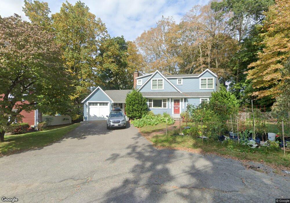
35 Colgate Rd Newton Lower Falls, MA 02462
Newton Lower Falls NeighborhoodEstimated Value: $1,274,000 - $1,705,775
3
Beds
2
Baths
1,745
Sq Ft
$890/Sq Ft
Est. Value
About This Home
This home is located at 35 Colgate Rd, Newton Lower Falls, MA 02462 and is currently estimated at $1,552,194, approximately $889 per square foot. 35 Colgate Rd is a home located in Middlesex County with nearby schools including Angier Elementary School, Charles E Brown Middle School, and Newton South High School.
Ownership History
Date
Name
Owned For
Owner Type
Purchase Details
Closed on
Apr 18, 2008
Sold by
Leaver Laura C and Leaver Robert B
Bought by
Stabile Catherine A and Day Matthew P
Current Estimated Value
Home Financials for this Owner
Home Financials are based on the most recent Mortgage that was taken out on this home.
Original Mortgage
$417,000
Interest Rate
6.1%
Mortgage Type
Purchase Money Mortgage
Purchase Details
Closed on
Aug 13, 1999
Sold by
Est Daly Emily M and Ballou Catherine M
Bought by
Leaver Robert B and Leaver Laura C
Home Financials for this Owner
Home Financials are based on the most recent Mortgage that was taken out on this home.
Original Mortgage
$283,500
Interest Rate
7.65%
Mortgage Type
Purchase Money Mortgage
Create a Home Valuation Report for This Property
The Home Valuation Report is an in-depth analysis detailing your home's value as well as a comparison with similar homes in the area
Home Values in the Area
Average Home Value in this Area
Purchase History
| Date | Buyer | Sale Price | Title Company |
|---|---|---|---|
| Stabile Catherine A | $627,025 | -- | |
| Leaver Robert B | $315,000 | -- |
Source: Public Records
Mortgage History
| Date | Status | Borrower | Loan Amount |
|---|---|---|---|
| Open | Leaver Robert B | $412,000 | |
| Closed | Stabile Catherine A | $417,000 | |
| Previous Owner | Leaver Robert B | $38,500 | |
| Previous Owner | Leaver Robert B | $283,500 |
Source: Public Records
Tax History Compared to Growth
Tax History
| Year | Tax Paid | Tax Assessment Tax Assessment Total Assessment is a certain percentage of the fair market value that is determined by local assessors to be the total taxable value of land and additions on the property. | Land | Improvement |
|---|---|---|---|---|
| 2025 | $14,156 | $1,444,500 | $821,800 | $622,700 |
| 2024 | $13,687 | $1,402,400 | $797,900 | $604,500 |
| 2023 | $13,097 | $1,286,500 | $614,800 | $671,700 |
| 2022 | $12,531 | $1,191,200 | $569,300 | $621,900 |
| 2021 | $12,092 | $1,123,800 | $537,100 | $586,700 |
| 2020 | $11,732 | $1,123,800 | $537,100 | $586,700 |
| 2019 | $8,079 | $773,100 | $521,500 | $251,600 |
| 2018 | $7,657 | $707,700 | $469,800 | $237,900 |
| 2017 | $7,424 | $667,600 | $443,200 | $224,400 |
| 2016 | $7,100 | $623,900 | $414,200 | $209,700 |
| 2015 | $6,770 | $583,100 | $387,100 | $196,000 |
Source: Public Records
Map
Nearby Homes
- 45 Moulton St
- 17 Deforest Rd
- 25 Columbia St
- 2084 Washington St
- 45 E Quinobequin Rd
- 7 Crescent St
- 34 Palmer Rd
- 177 Varick Rd
- 2 Longfellow Rd
- 10 Lorraine Cir
- 12 Bird Hill Ave
- 27 Oakwood Rd
- 8 Old Town Rd
- 33 Metacomet Rd
- 20 Oakland Street Front
- 1801 Beacon St
- 135 Orchard Ave
- 41 Orchard Ave
- 17 Lasell St
- 54 Colburn Rd